Carneys Point Township, New Jersey facts for kids
Quick facts for kids
Carneys Point Township, New Jersey
|
|
|---|---|
|
Township
|
|
| Township of Carneys Point | |

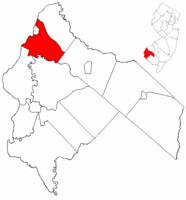
Carneys Point Township highlighted in Salem County. Inset map: Salem County highlighted in the State of New Jersey.
|
|

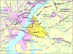
Census Bureau map of Carneys Point Township, New Jersey
|
|
| Country | |
| State | |
| County | |
| Formed | July 10, 1721 as Upper Penns Neck Township |
| Incorporated | February 21, 1798 |
| Renamed | November 10, 1976 as Carneys Point Township |
| Government | |
| • Type | Township |
| • Body | Township Committee |
| Area | |
| • Total | 17.78 sq mi (46.05 km2) |
| • Land | 16.91 sq mi (43.80 km2) |
| • Water | 0.87 sq mi (2.25 km2) 4.88% |
| Area rank | 162nd of 565 in state 10th of 15 in county |
| Elevation | 3 ft (0.9 m) |
| Population | |
| • Total | 8,049 |
| • Estimate
(2019)
|
7,674 |
| • Rank | 286th of 566 in state 3rd of 15 in county |
| • Density | 477.3/sq mi (184.3/km2) |
| • Density rank | 446th of 566 in state 6th of 15 in county |
| Time zone | UTC−05:00 (Eastern (EST)) |
| • Summer (DST) | UTC−04:00 (Eastern (EDT)) |
| ZIP Code |
08069
|
| Area code(s) | 856 Exchanges: 299, 351 |
| FIPS code | 3403310610 |
| GNIS feature ID | 0882135 |
| Website | |
Carneys Point Township is a township in Salem County, New Jersey, United States. As of the 2010 United States Census, the township's population was 8,049, reflecting an increase of 365 (+4.8%) from the 7,684 counted in the 2000 Census, which had in turn declined by 759 (-9.0%) from the 8,443 counted in the 1990 Census.
Upper Penns Neck Township was formed on July 10, 1721, when Penn's Neck Township was subdivided and Lower Penns Neck Township (now Pennsville Township) was also formed. The township was incorporated by an act of the New Jersey Legislature on February 21, 1798, as one of New Jersey's original group of 104 townships. Portions of the township were taken to form Oldmans Township (February 7, 1881) and Penns Grove borough (March 8, 1894). The township was renamed Carneys Point Township based on the results of a Township meeting held on November 10, 1976, after voters approved a referendum held eight days earlier.
Contents
Geography
According to the United States Census Bureau, the township had a total area of 17.739 square miles (45.944 km2), including 16.864 square miles (43.678 km2) of land and 0.875 square miles (2.266 km2) of water (4.93%). The Salem River flows along a portion of the township's southern boundary.
Carneys Point CDP (with a 2010 Census population of 7,382) is a unincorporated community and census-designated place (CDP) located within Carneys Point Township.
Other unincorporated communities, localities and place names located partially or completely within the township include Biddles Landing, Helms Cove, Iddles Landing, Laytons Lake, and Riddles Landing.
The township borders the Salem County municipalities of Mannington Township, Pennsville Township, Oldmans Township, Penns Grove and Pilesgrove Township.
Carneys Point Township is connected to the State of Delaware by the Delaware Memorial Bridges over the Delaware River.
Dupont Chambers Work
The town is home to Dupont Corporation Chamber Works. The facility was listed No. 4 on the Mother Jones Top 20 polluters of 2010, legally discharging over 5,000,000 pounds (2,300,000 kg) of toxic chemicals into New Jersey/Delaware waterways. In 2016, the township initiated a $1.1 billion lawsuit against the corporation, accusing it of divesting an unprofitable company with out first remediating the property as required by law.
Demographics
| Historical population | |||
|---|---|---|---|
| Census | Pop. | %± | |
| 1810 | 1,638 | — | |
| 1820 | 1,861 | 13.6% | |
| 1830 | 1,638 | −12.0% | |
| 1840 | 1,854 | 13.2% | |
| 1850 | 2,422 | 30.6% | |
| 1860 | 2,901 | 19.8% | |
| 1870 | 3,178 | 9.5% | |
| 1880 | 3,301 | 3.9% | |
| 1890 | 2,239 | −32.2% | |
| 1900 | 775 | −65.4% | |
| 1910 | 744 | −4.0% | |
| 1920 | 6,259 | 741.3% | |
| 1930 | 3,879 | −38.0% | |
| 1940 | 4,805 | 23.9% | |
| 1950 | 6,717 | 39.8% | |
| 1960 | 7,595 | 13.1% | |
| 1970 | 7,016 | −7.6% | |
| 1980 | 8,396 | 19.7% | |
| 1990 | 8,443 | 0.6% | |
| 2000 | 7,684 | −9.0% | |
| 2010 | 8,049 | 4.8% | |
| 2019 (est.) | 7,674 | −4.7% | |
| Population sources: 1810-2000 1810-1920 1840 1850-1870 1850 1870 1880-1890 1890-1910 1910-1930 1900-1990 2000 2010 * = Lost territory in previous decade. |
|||
Census 2010
As of the census of 2010, there were 8,049 people, 3,264 households, and 2,033 families residing in the township. The population density was 477.3 per square mile (184.3/km2). There were 3,502 housing units at an average density of 207.7 per square mile (80.2/km2)*. The racial makeup of the township was 74.08% (5,963) White, 16.91% (1,361) Black or African American, 0.21% (17) Native American, 0.81% (65) Asian, 0.00% (0) Pacific Islander, 5.65% (455) from other races, and 2.34% (188) from two or more races. [[Hispanic (U.S. Census)|Hispanic or Latino of any race were 11.18% (900) of the population.
There were 3,264 households out of which 23.7% had children under the age of 18 living with them, 43.8% were married couples living together, 13.3% had a female householder with no husband present, and 37.7% were non-families. 32.2% of all households were made up of individuals, and 14.0% had someone living alone who was 65 years of age or older. The average household size was 2.36 and the average family size was 2.97.
In the township, the population was spread out with 20.1% under the age of 18, 7.4% from 18 to 24, 24.7% from 25 to 44, 29.1% from 45 to 64, and 18.7% who were 65 years of age or older. The median age was 43.2 years. For every 100 females there were 90.2 males. For every 100 females ages 18 and old there were 85.3 males.
The Census Bureau's 2006-2010 American Community Survey showed that (in 2010 inflation-adjusted dollars) median household income was $51,277 (with a margin of error of +/- $4,039) and the median family income was $65,224 (+/- $7,825). Males had a median income of $46,529 (+/- $2,972) versus $39,722 (+/- $5,309) for females. The per capita income for the borough was $26,020 (+/- $2,212). About 4.3% of families and 7.5% of the population were below the poverty line, including 11.2% of those under age 18 and 8.1% of those age 65 or over.
Census 2000
As of the 2000 United States Census there were 7,684 people, 3,121 households, and 2,050 families residing in the township. The population density was 439.1 people per square mile (169.5/km2). There were 3,330 housing units at an average density of 190.3 per square mile (73.5/km2). The racial makeup of the township was 78.53% White, 16.27% African American, 0.27% Native American, 0.91% Asian, 0.04% Pacific Islander, 2.10% from other races, and 1.89% from two or more races. Hispanic or Latino of any race were 3.98% of the population.
There were 3,121 households, out of which 28.3% had children under the age of 18 living with them, 48.7% were married couples living together, 12.9% had a female householder with no husband present, and 34.3% were non-families. 29.3% of all households were made up of individuals, and 12.1% had someone living alone who was 65 years of age or older. The average household size was 2.42 and the average family size was 2.99.
In the township the population was spread out, with 22.9% under the age of 18, 8.6% from 18 to 24, 28.1% from 25 to 44, 24.3% from 45 to 64, and 16.2% who were 65 years of age or older. The median age was 39 years. For every 100 females, there were 91.3 males. For every 100 females age 18 and over, there were 87.3 males.
The median income for a household in the township was $41,007, and the median income for a family was $52,213. Males had a median income of $39,861 versus $26,773 for females. The per capita income for the township was $19,978. About 8.3% of families and 10.8% of the population were below the poverty line, including 11.9% of those under age 18 and 9.0% of those age 65 or over.
Transportation
Roads and highways
Carneys Point hosts various state routes, US routes, and limited access roads. As of May 2010[update], the township had a total of 78.17 miles (125.80 km) of roadways, of which 35.61 miles (57.31 km) were maintained by the municipality, 20.50 miles (32.99 km) by Salem County and 17.37 miles (27.95 km) by the New Jersey Department of Transportation and 4.69 miles (7.55 km) by the New Jersey Turnpike Authority.
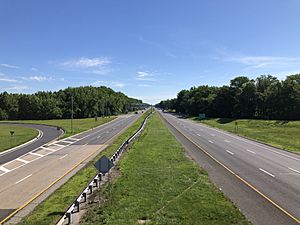
The New Jersey Turnpike is the most significant highway to travel through the township, which houses Interchange 1 and its high-speed toll gate featuring E-ZPass Express Lanes, and a "lighthouse" to mark the gateway of New Jersey. Interstate 295 also passes through and two exits are within the township: Exits 2 and 4. U.S. Route 40 runs through the southern part of the municipality while U.S. Route 130 travels through the northwest and goes right into Carneys Point. For state roads, the township houses Route 48, Route 49 and Route 140. Two major county routes that pass through are County Route 540 and County Route 551.
Public transportation
NJ Transit offers bus service to Philadelphia on the 402 route, with local service offered on the 423 and 468 routes.
Education
Students in public school for pre-kindergarten through twelfth grade attend the Penns Grove-Carneys Point Regional School District, together with students from Penns Grove. Most students in grades 9 to 12 from Oldmans Township attend the district's high school as part of a sending/receiving relationship with the Oldmans Township School District, with the balance attending Woodstown High School in the Woodstown-Pilesgrove Regional School District.
As of the 2018–19 school year, the district, comprised of five schools, had an enrollment of 2,185 students and 182.0 classroom teachers (on an FTE basis), for a student–teacher ratio of 12.0:1. Schools in the district (with 2018–19 enrollment data from the National Center for Education Statistics) are Lafayette-Pershing School with 331 students in grades Pre-K to Kindergarten, Field Street School with 480 students in grades 1 - 3, Paul W. Carleton School with 355 students in grades 4 - 5, Penns Grove Middle School with 465 students in grades 6 - 8 and Penns Grove High School with 508 students in grades 9 - 12.
The Catholic K-8 school Bishop Guilfoyle Regional Catholic School in Carneys Point closed in 2010. As of 2020[update] Guardian Angels Regional School (Pre-K-Grade 3 campus in Gibbstown CDP and 4-8 campus in Paulsboro) takes students from Carneys Point.
Notable people
People who were born in, residents of, or otherwise closely associated with Carneys Point Township include:
- Johnny Gaudreau (born 1993), professional ice hockey left winger for the Calgary Flames of the NHL.
- Betty Metcalf (1921-2017), Florida state representative and clinical psychologist, was born in Carneys Point Township.
- Mike Shawaryn (born 1994), professional baseball player.
- Bruce Willis (born 1955), actor.
See also
 In Spanish: Municipio de Carneys Point para niños


