
Bishop, California facts for kids
Quick facts for kids
City of Bishop
|
|
|---|---|

Downtown Bishop looking south along U.S. 395
|
|

Location of Bishop in Inyo County, California
|
|

Bishop, California
Location in California
|
|
| Country | United States |
| State | California |
| County | Inyo |
| Incorporated | May 6, 1903 |
| Named for | Bishop Creek |
| Area | |
| • City | 1.91 sq mi (4.95 km2) |
| • Land | 1.86 sq mi (4.83 km2) |
| • Water | 0.05 sq mi (0.12 km2) 2.5% |
| Elevation | 4,150 ft (1,260 m) |
| Population
(2020)
|
|
| • City | 3,819 |
| • Density | 2,048.82/sq mi (791.14/km2) |
| • Metro | 14,500 |
| Time zone | UTC−8 (Pacific) |
| • Summer (DST) | UTC−7 (PDT) |
| ZIP codes |
93514, 93515
|
| Area codes | 442/760 |
| FIPS code | 06-06798 |
| GNIS feature IDs | 277475, 2409852 |
Bishop (formerly Bishop Creek) is a city in California, United States. It is the largest populated place and only incorporated city in Inyo County. Bishop is located near the northern end of the Owens Valley, at an elevation of 4,150 feet (1,260 m). The city was named after Bishop Creek, flowing out of the Sierra Nevada; the creek was named after Samuel Addison Bishop, a settler in the Owens Valley. Bishop is a commercial and residential center, while many vacation destinations and tourist attractions in the Sierra Nevada are located nearby.
The population of the city was 3,879 at the 2010 Census, up from 3,575 at the 2000 Census. The population of the built-up zone containing Bishop is much larger; more than 14,500 people live in a compact area that includes Bishop, West Bishop, Dixon Lane-Meadow Creek, and the Bishop Paiute Reservation. It is by far the largest settlement in Inyo County.
A number of western films were shot in Bishop, including movies starring John Wayne, Charlton Heston and Joel McCrea.
Contents
Geography
Bishop lies west of the Owens River at the northern end of the Owens Valley.
It is on U.S. Route 395, the main north-south artery through the Owens Valley, connecting the Inland Empire to Reno, Nevada. US 395 also connects Bishop to Los Angeles via State Route 14 through Palmdale. Bishop is the western terminus of U.S. Route 6. The Paiute-Shoshone Indians of the Bishop Community of the Bishop Colony control land just west of the town. The Los Angeles Department of Water and Power (DWP) controls much of the upstream and surrounding area.
Bishop is immediately to the east of the Sierra Nevada, and west of the White Mountains. Numerous peaks are within a short distance of Bishop, including Mount Humphreys (13,986 ft.), to the west, White Mountain Peak (14,242 ft.) in the northeast, and pyramidal Mount Tom (13,658 ft.) northwest of town. Basin Mountain (13,187 ft.) is viewed to the west from Bishop as it rises above the Buttermilks.
According to the United States Census Bureau, the city has a total area of 1.9 square miles (4.9 km2), over 97% of it land.
Bishop is known as the "Mule Capital of the World" and a week-long festival called Bishop Mule Days has been held since 1969 on the week of Memorial Day, celebrating the contributions of pack mules to the area. The festival attracts many tourists, primarily from the Southern California area.
Bishop is well known in the rock climbing community. Near the city are numerous climbing spots that attract visitors from around the world. There are over 2,000 bouldering problems in Bishop. The two main types of rock are volcanic tuff and granite.

Notable locations
- Inyo National Forest Supervisor's Office
- Paiute Indian Reservation
- Laws Rail Museum
- Mountain Light Gallery
- Keough Hot Springs
- Eastern Sierra Regional Airport
Climate
Bishop, as well as the rest of the Owens Valley, has an arid climate (Köppen BWk) with an annual average of 5.18 inches (132 mm) of precipitation, and is part of USDA Plant Hardiness Zone 7. The wettest year was 1969 with 17.09 in (434 mm) of precipitation and the driest 1989 with 1.81 in (46.0 mm), although from July 2006 to June 2007 a mere 1.46 inches (37.1 mm) fell. Measurable precipitation occurs on an average of 27.6 days annually. The most precipitation in one month was 8.93 in (227 mm) in January 1969, which included 4.00 in (102 mm) on January 4, the most rainfall recorded in 24 hours in Bishop. Snowfall averages 6.8 inches (17 cm) per year. The snowiest season was from July 1968 to June 1969 with 57.1 inches (145 cm), which included the snowiest month, January 1969, at 23.2 inches (59 cm).
There is an average of 2.5 nights of sub 10 °F (−12 °C) lows, 134 nights where the low reaches the freezing mark, 100 days with 90 °F (32 °C)+ highs, and 25 days with 100 °F (38 °C)+ highs. Due to the aridity and hot high-altitude sun, there are only 32 days with maxima below 50 °F (10 °C) and only one per year with a maximum below 32 °F (0 °C), and the annual diurnal temperature variation is 36.9 °F (20.5 °C), reaching 42 °F (23 °C) in summer. The record high temperature of 110 °F (43 °C) occurred on July 10, 2002; the record low of −8 °F (−22 °C) was recorded on December 22, 1990 and December 27, 1988.
| Climate data for Bishop, California (Eastern Sierra Regional Airport), 1981–2010 normals, extremes 1943–present | |||||||||||||
|---|---|---|---|---|---|---|---|---|---|---|---|---|---|
| Month | Jan | Feb | Mar | Apr | May | Jun | Jul | Aug | Sep | Oct | Nov | Dec | Year |
| Record high °F (°C) | 77 (25) |
81 (27) |
87 (31) |
93 (34) |
102 (39) |
109 (43) |
110 (43) |
107 (42) |
106 (41) |
97 (36) |
84 (29) |
78 (26) |
110 (43) |
| Mean maximum °F (°C) | 67.4 (19.7) |
70.7 (21.5) |
77.3 (25.2) |
85.7 (29.8) |
94.3 (34.6) |
101.8 (38.8) |
105.4 (40.8) |
103.3 (39.6) |
97.5 (36.4) |
87.3 (30.7) |
76.0 (24.4) |
66.8 (19.3) |
106.1 (41.2) |
| Average high °F (°C) | 54.0 (12.2) |
57.9 (14.4) |
65.5 (18.6) |
72.7 (22.6) |
82.4 (28.0) |
92.0 (33.3) |
98.4 (36.9) |
96.3 (35.7) |
88.2 (31.2) |
76.1 (24.5) |
62.6 (17.0) |
53.3 (11.8) |
75.0 (23.9) |
| Average low °F (°C) | 23.0 (−5.0) |
26.5 (−3.1) |
31.2 (−0.4) |
36.3 (2.4) |
44.2 (6.8) |
51.0 (10.6) |
56.2 (13.4) |
53.8 (12.1) |
47.0 (8.3) |
37.4 (3.0) |
27.8 (−2.3) |
22.1 (−5.5) |
38.1 (3.4) |
| Mean minimum °F (°C) | 11.0 (−11.7) |
14.5 (−9.7) |
18.9 (−7.3) |
24.1 (−4.4) |
32.4 (0.2) |
39.2 (4.0) |
46.7 (8.2) |
44.4 (6.9) |
36.8 (2.7) |
25.4 (−3.7) |
15.4 (−9.2) |
9.7 (−12.4) |
6.6 (−14.1) |
| Record low °F (°C) | −7 (−22) |
−2 (−19) |
9 (−13) |
15 (−9) |
25 (−4) |
25 (−4) |
34 (1) |
34 (1) |
26 (−3) |
16 (−9) |
5 (−15) |
−8 (−22) |
−8 (−22) |
| Average precipitation inches (mm) | 1.05 (27) |
0.85 (22) |
0.53 (13) |
0.26 (6.6) |
0.19 (4.8) |
0.19 (4.8) |
0.16 (4.1) |
0.13 (3.3) |
0.19 (4.8) |
0.30 (7.6) |
0.52 (13) |
0.80 (20) |
5.17 (131) |
| Average snowfall inches (cm) | 5.2 (13) |
0.7 (1.8) |
0.5 (1.3) |
0.1 (0.25) |
trace | 0 (0) |
0 (0) |
0 (0) |
0 (0) |
0 (0) |
0.3 (0.76) |
1.2 (3.0) |
6.8 (17) |
| Average precipitation days (≥ 0.01 in) | 3.9 | 4.0 | 2.9 | 1.9 | 1.7 | 1.5 | 1.7 | 1.5 | 1.7 | 1.5 | 2.3 | 3.0 | 27.6 |
| Average snowy days (≥ 0.1 in) | 1.2 | 0.4 | 0.4 | 0.1 | 0 | 0 | 0 | 0 | 0 | 0 | 0.2 | 0.7 | 3.0 |
| Source: NOAA, WRCC | |||||||||||||
Demographics
| Historical population | |||
|---|---|---|---|
| Census | Pop. | %± | |
| 1880 | 152 | — | |
| 1890 | 340 | 123.7% | |
| 1910 | 1,199 | — | |
| 1920 | 1,304 | 8.8% | |
| 1930 | 1,159 | −11.1% | |
| 1940 | 1,490 | 28.6% | |
| 1950 | 2,891 | 94.0% | |
| 1960 | 2,875 | −0.6% | |
| 1970 | 3,498 | 21.7% | |
| 1980 | 3,333 | −4.7% | |
| 1990 | 3,475 | 4.3% | |
| 2000 | 3,575 | 2.9% | |
| 2010 | 3,879 | 8.5% | |
| 2020 | 3,819 | −1.5% | |
| U.S. Decennial Census | |||
The demographic information below applies to residents living within the city limits of Bishop; 3,879 in downtown Bishop.
The "greater Bishop area," which includes unincorporated nearby neighborhoods such as West Bishop, Meadow Creek-Dixon Lane, Wilkerson Ranch, Rocking K, Mustang Mesa, Round Valley and the Bishop Paiute Tribe includes an additional 11,000 residents.
2010
The 2010 United States Census reported that Bishop had a population of 3,879. The population density was 2,029.9 people per square mile (783.8/km2). The racial makeup of Bishop was 2,867 (73.9%) White, 22 (0.6%) African American, 91 (2.3%) Native American, 61 (1.6%) Asian, 1 (0.0%) Pacific Islander, 723 (18.6%) from other races, and 114 (2.9%) from two or more races. Hispanic or Latino of any race were 1,200 persons (30.9%).
The Census reported that 3,771 people (97.2% of the population) lived in households, 36 (0.9%) lived in non-institutionalized group quarters, and 72 (1.9%) were institutionalized.
There were 1,748 households, out of which 499 (28.5%) had children under the age of 18 living in them, 574 (32.8%) were opposite-sex married couples living together, 181 (10.4%) had a female householder with no husband present, 99 (5.7%) had a male householder with no wife present. There were 143 (8.2%) unmarried opposite-sex partnerships, and 10 (0.6%) same-sex married couples or partnerships. 767 households (43.9%) were made up of individuals, and 288 (16.5%) had someone living alone who was 65 years of age or older. The average household size was 2.16. There were 854 families (48.9% of all households); the average family size was 3.07.
The population was spread out, with 925 people (23.8%) under the age of 18, 298 people (7.7%) aged 18 to 24, 1,014 people (26.1%) aged 25 to 44, 1,031 people (26.6%) aged 45 to 64, and 611 people (15.8%) who were 65 years of age or older. The median age was 38.9 years. For every 100 females, there were 99.8 males. For every 100 females age 18 and over, there were 97.7 males.
There were 1,926 housing units at an average density of 1,007.9 per square mile (389.2/km2), 1,748 of which were occupied, of which 676 (38.7%) were owner-occupied, and 1,072 (61.3%) were occupied by renters. The homeowner vacancy rate was 0.3%; the rental vacancy rate was 5.8%. 1,353 people (34.9% of the population) lived in owner-occupied housing units and 2,418 people (62.3%) lived in rental housing units.
2000
.jpg)
As of the census of 2000, there were 3,575 people, 1,684 households, and 831 families residing in the city. The population density was 2,042.5 people per square mile (788.8/km2). There were 1,867 housing units at an average density of 1,066.7 per square mile (411.9/km2). The racial makeup of the city was 84.6% White, 0.2% Black or African American, 2.0% Native American, 1.4% Asian, <0.1% Pacific Islander, 6.5% from other races, and 5.4% from two or more races. 17.4% of the population were Hispanic or Latino of any race.
There were 1,684 households, out of which 26.2% had children under the age of 18 living with them, 33.5% were married couples living together, 11.8% had a female householder with no husband present, and 50.6% were non-families. 44.2% of all households were made up of individuals, and 19.1% had someone living alone who was 65 years of age or older. The average household size was 2.08 and the average family size was 2.93.
In the city the population was spread out, with 24.2% under the age of 18, 7.3% from 18 to 24, 26.5% from 25 to 44, 22.8% from 45 to 64, and 19.2% who were 65 years of age or older. The median age was 40 years. For every 100 females, there were 91.8 males. For every 100 females age 18 and over, there were 90.0 males.
The median income for a household in the city was $27,338, and the median income for a family was $34,423. Males had a median income of $23,433 versus $24,545 for females. The per capita income for the city was $17,660. About 14.0% of families and 16.3% of the population were below the poverty line, including 23.0% of those under age 18 and 6.0% of those age 65 or over.
Transportation
U.S. Route 395 is the four lane divided highway serving Bishop between southern California and Reno while U.S. 6 provides access to Tonopah and other communities in Nevada. The junction of U.S. Routes 395 and 6 is one of only two junctions of two U.S. Routes in California, the other being the junction of U.S. Routes 199 and 101 in Crescent City.
The Eastern Sierra Regional Airport provides general aviation services in addition to seasonal scheduled passenger airline service nonstop to Los Angeles, San Francisco and Denver operated by SkyWest Airlines flying as United Express with regional jet aircraft on behalf of United Airlines.
Eastern Sierra Transit offers bus service as far north as Reno, Nevada, and as far south as Lancaster, California.
History
The Bishop Creek post office operated from 1870 to 1889 and from 1935 to 1938. The first Bishop post office opened in 1889.
In order to support the growth aspirations of the City of Los Angeles, water was diverted from the Owens River into the Los Angeles Aqueduct in 1913. The Owens Valley cultures and environments changed substantially. From the 1910s to 1930s the Los Angeles Department of Water and Power purchased much of the valley for water rights and control. The economy of Bishop suffered when farmers sold their land. Jack Foley, a Bishop resident and sound effects specialist, mitigated the economic loss by persuading several Los Angeles studio bosses that the town of Bishop would be ideal as a location to shoot westerns.
Erick Schat's Bakkerÿ
Erick Schat's Bakkerÿ is a bakery and tourist attraction in Bishop. It is known for a unique bread, called Original Sheepherder's Bread (trademarked in 1938) and produces 450 other products. The bakery produces approximately 25,000 loaves of bread per day, and they have produced their Sheepherder's bread continuously since 1907. The bakery uses a basque recipe. The bakery has a staff of 77 under the oversight of Erick Schat, and bakes the bread in stone hearth ovens, with no preservatives, with everything handmade from scratch, including the yeast.
Notable residents
- Horace M. Albright, the second director of the National Park Service, was born in Bishop in 1890.
- Television director and producer David Barrett also calls Bishop home, along with his brother, stuntman and NASCAR driver Stanton Barrett. They are grandsons to Dave McCoy, founder of the Mammoth Mountain Ski Area.
- Actor Robert Bray, who portrayed forest ranger Corey Stuart in CBS's Lassie from 1964 to 1968 and Simon Kane in ABC's Stagecoach West from 1960 to 1961, retired to Bishop, where he died in 1983 at the age of sixty-five.
- Artist Robert Clunie lived and painted in Bishop for decades.
- Elisha Vanslyck Cook Jr. was a character actor in dozens of films, including The Maltese Falcon, The Big Sleep and Shane, who lived in Bishop until his death in Big Pine in 1995.
- Mountaineer Peter Croft lives in Bishop.
- Major Kern W. Dunagan US Army Medal of Honor recipient graduated from Bishop High School.
- Actor Trevor Donovan was born in Bishop.
- Former child actor Richard Eyer, who played Bray's son in Stagecoach West, was a teacher in Bishop, until he retired.
- Cowboy poet Curley Fletcher (1892–1954) was raised in Bishop.
- Jack Foley is the namesake for the art of adding sound effects to films, with the profession named Foley artist.
- Major League Baseball pitcher Hal Gregg lived in Bishop until his death there in 1991.
- Jill Kinmont, noted ski racer who was paralyzed in a 1955 accident, grew up in Bishop. Her life story was turned into two major Hollywood movies The Other Side of the Mountain and its sequel The Other Side of the Mountain Part 2.
- Actor Bill Mumy spent part of his childhood and adolescence in Bishop, where his father was a cattle rancher.
- Bishop was the home of Galen Rowell, and his wife Barbara, before their death at the Eastern Sierra Regional Airport.
- Tracy Smith, Olympian, world-record holder in the 3-mile, and 6-time AAU national champion, was a Bishop resident from the 1970s to the 1990s, as he coached the Bishop Union High School track team distance runners.
- Artist Alex Stenzel lives in Bishop.
- Matt Williams, former Major League Baseball third baseman and former manager of the Washington Nationals, was born in Bishop.
Images for kids
-
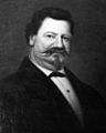
Samuel Addison Bishop in 1870
-
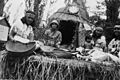
Example of Paiute Hut, re-constructed for a float in a parade in Bishop, 1940


See also
 In Spanish: Bishop (California) para niños
