Black Hawk County, Iowa facts for kids
Quick facts for kids
Black Hawk County
|
|
|---|---|

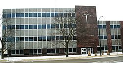
Black Hawk County Courthouse in Waterloo
|
|

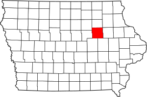
Location within the U.S. state of Iowa
|
|
 Iowa's location within the U.S. |
|
| Country | |
| State | |
| Founded | 1843 |
| Named for | Black Hawk |
| Seat | Waterloo |
| Largest city | Waterloo |
| Area | |
| • Total | 573 sq mi (1,480 km2) |
| • Land | 566 sq mi (1,470 km2) |
| • Water | 6.9 sq mi (18 km2) 1.2% |
| Population
(2020)
|
|
| • Total | 131,144 |
| • Density | 228.87/sq mi (88.37/km2) |
| Time zone | UTC−6 (Central) |
| • Summer (DST) | UTC−5 (CDT) |
| Congressional district | 1st |
Black Hawk County is a county in the northeastern part of U.S. state of Iowa. As of the 2020 census, the population was 131,144, making it Iowa's fifth-most populous county. The county seat is Waterloo.
Black Hawk County is part of the Waterloo-Cedar Falls, IA Metropolitan Statistical Area.
Contents
History
Black Hawk County was formed on February 17, 1843 from sections of Buchanan County. It was named after Black Hawk, a Sauk leader during the 1832 Black Hawk War.
Geography
According to the U.S. Census Bureau, the county has an area of 573 square miles (1,480 km2), of which 566 square miles (1,470 km2) is land and 6.9 square miles (18 km2) (1.2%) is water.
The Cedar River roughly divides the county in half from the northwest to the southeast corner. The land is mostly level since much of it is on the river's flood plain.
Major highways
Adjacent counties
- Bremer County (north)
- Buchanan County (east)
- Benton County (southeast)
- Tama County (southwest)
- Grundy County (west)
- Butler County (northwest)
- Fayette County (northeast)
Demographics
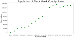
| Historical population | |||
|---|---|---|---|
| Census | Pop. | %± | |
| 1850 | 135 | — | |
| 1860 | 8,244 | 6,006.7% | |
| 1870 | 21,706 | 163.3% | |
| 1880 | 23,913 | 10.2% | |
| 1890 | 24,219 | 1.3% | |
| 1900 | 32,399 | 33.8% | |
| 1910 | 44,865 | 38.5% | |
| 1920 | 56,570 | 26.1% | |
| 1930 | 69,146 | 22.2% | |
| 1940 | 79,946 | 15.6% | |
| 1950 | 100,448 | 25.6% | |
| 1960 | 122,482 | 21.9% | |
| 1970 | 132,916 | 8.5% | |
| 1980 | 137,961 | 3.8% | |
| 1990 | 123,798 | −10.3% | |
| 2000 | 128,012 | 3.4% | |
| 2010 | 131,090 | 2.4% | |
| 2020 | 131,144 | 0.0% | |
| U.S. Decennial Census 1790-1960 1900-1990 1990-2000 2010-2019 |
|||
2020 census
The 2020 census recorded a population of 131,144 in the county, with a population density of 229.5011/sq mi (88.6109/km2). 94.55% of the population reported being of one race. 73.49% were non-Hispanic White, 10.43% were Black, 4.92% were Hispanic, 0.32% were Native American, 2.61% were Asian, 0.65% were Native Hawaiian or Pacific Islander and 7.57% were some other race or more than one race. There were 58,559 housing units of which 54,223 were occupied.
2010 census
The 2010 census recorded a population of 131,090 in the county, with a population density of 231.20/sq mi (89.27/km2). There were 55,887 housing units, of which 52,470 were occupied.
Communities
Cities
Census-designated place
Other unincorporated communities
- Dewar
- Eagle Center
- Finchford
- Glasgow
- Voorhies
Townships
Black Hawk County is divided into seventeen townships:
- Barclay
- Bennington
- Big Creek
- Black Hawk
- Cedar
- Cedar Falls
- Eagle
- East Waterloo
- Fox
- Lester
- Lincoln
- Mount Vernon
- Orange
- Poyner
- Spring Creek
- Union
- Washington
Population ranking
The population ranking of the following table is based on the 2010 census of Black Hawk County.
† county seat
| Rank | City/Town/etc. | Municipal type | Population (2010 Census) |
|---|---|---|---|
| 1 | † Waterloo | City | 68,406 |
| 2 | Cedar Falls | City | 39,260 |
| 3 | Evansdale | City | 4,751 |
| 4 | Jesup (mostly in Buchanan County) | City | 2,520 |
| 5 | La Porte City | City | 2,285 |
| 6 | Hudson | City | 2,282 |
| 7 | Elk Run Heights | City | 1,117 |
| 8 | Janesville (mostly in Bremer County) | City | 930 |
| 9 | Washburn | CDP | 876 |
| 10 | Dunkerton | City | 852 |
| 11 | Raymond | City | 788 |
| 12 | Gilbertville | City | 712 |
See also
 In Spanish: Condado de Black Hawk para niños


