
Blackall, Queensland facts for kids
Quick facts for kids BlackallQueensland |
|||||||||||||||
|---|---|---|---|---|---|---|---|---|---|---|---|---|---|---|---|

Memorial to Sir Thomas Mitchell
|
|||||||||||||||

Blackall
Location in Queensland
|
|||||||||||||||
| Population | 1,416 (2016 census) | ||||||||||||||
| • Density | 0.085525/km2 (0.22151/sq mi) | ||||||||||||||
| Established | 1868 | ||||||||||||||
| Postcode(s) | 4472 | ||||||||||||||
| Elevation | 284 m (932 ft) | ||||||||||||||
| Area | 16,556.6 km2 (6,392.5 sq mi) | ||||||||||||||
| Time zone | AEST (UTC+10:00) | ||||||||||||||
| LGA(s) | Blackall-Tambo Region | ||||||||||||||
| State electorate(s) | Gregory | ||||||||||||||
| Federal Division(s) | Flynn | ||||||||||||||
|
|||||||||||||||
|
|||||||||||||||
Blackall is a rural town and locality in the Blackall-Tambo Region, Queensland, Australia. In the 2016 census the locality of Blackall had a population of 1,416 people.
The town is the service centre for the Blackall-Tambo Region. The dominant industry in the area is grazing.
Yalleroi is another town in the north of the locality (24°04′05″S 145°45′33″E / 24.0680°S 145.7591°E).
Contents
Geography
Blackall is approximately 960 kilometres (600 mi) by road from the state capital, Brisbane. The town is situated on the Barcoo River and Landsborough Highway (Matilda Highway).
Blackall claims to be the home of the original Black Stump, which marks the original Astro Station established in 1887. Places west of this point are said to be 'beyond the black stump'. The Black Stump was moved from its original location to make it more accessible to tourists, and can now be found on the boundary of the Blackall State School grounds, Thistle Street, Blackall. Blackall has many attractions for public use and entertainment, including the Blackall showground, the local pool and the historic Blackall Woolscour.
History
The region was explored in 1846 by explorer Sir Thomas Mitchell and his party. In 1856, Augustus Gregory passed through the area noting that the landscape was a vast plain lacking vegetation in contrast to Mitchell's description of good country. Blackall was named by Surveyor Abraham H. May after Sir Samuel Blackall, the second Governor of Queensland. During the 1860s the town developed as a service centre for the surrounding pastoral properties. A survey of town allotments was conducted in 1868.
Barcoo Post Office opened on 1 April 1864. It was renamed Blackall in 1868.
Blackall State School opened on 10 September 1877. On 5 October 1964, the school was destroyed by fire, but was subsequently rebuilt.
On Tuesday 29 March 1881, following seven inches of rain, the river burst through the town embankment, completely washing away the stonework of the dam. On Wednesday 30 March, the still-rising river flooded the town's main street and many people in the town's lower-lying areas were forced to evacuate as their homes became fully submerged.
Blackall was one of the first Queensland towns to sink an artesian bore in 1885, which now supplies the town with water from the Great Artesian Basin. The water temperature is 58 degrees Celsius. There is an artesian spa bath at the aquatic centre and locally produced soft drinks are made from the artesian water.
In December 1890 the Australian Labor Party constitution and rules were drawn up at Blackall, during the founding of this party. In Australian folklore, the best known citizen of the town was the shearer Jack Howe. In 1892, he shore a total of 321 sheep at Alice Downs station in 7 hours and 40 minutes, a record for hand shearing that still stands, and was only broken by a shearer using a machine driven handpiece in 1950. A branch line from the Central Western railway reached Blackall in 1908.
St Joseph's Catholic Primary School was established in 1917 by the Sisters of St Joseph. The opening ceremonies were conducted on Saturday 21 July 1917 by Archbishop James Duhig.
The Blackall War Memorial commemorates those soldiers who died in World War I. The memorial was dedicated on the 25 April (Anzac Day) 1927 by James Charles Minnis (former mayor of Blackall and a former soldier). The honour roll of those who died in World War II was added later.
Blackall's population was more than 3,000 in 1965. A declining population has coincided with the decline in the wool industry in the district.
Heritage listings
Blackall has a number of heritage-listed sites, including:
- Hawthorn Street: Blackall Masonic Temple
- 4 kilometres (2.5 mi) northeast of Blackall: Blackall Woolscour
Transport
Blackall Airport is on Aerodrome Road (24°25′41″S 145°25′38″E / 24.4280°S 145.4273°E). QantasLink has services connecting the town to Longreach and Brisbane.
Blackall is also a timetabled meal stop for Bus Queensland's long-distance bus services:
Facilities
Blackall has a public library, showground, racecourse, golf course, bowling club and aquatic centre, cultural centre and an historical association.
The Blackall Golf Club has an 18-hole golf course at Shamrock Street (24°25′18″S 145°27′10″E / 24.42172°S 145.45276°E).
Climate
The town has a semi-arid climate according to Köppen (BSh).
| Climate data for Blackall | |||||||||||||
|---|---|---|---|---|---|---|---|---|---|---|---|---|---|
| Month | Jan | Feb | Mar | Apr | May | Jun | Jul | Aug | Sep | Oct | Nov | Dec | Year |
| Record high °C (°F) | 44.6 (112.3) |
43.9 (111.0) |
41.8 (107.2) |
37.3 (99.1) |
35.0 (95.0) |
32.8 (91.0) |
31.3 (88.3) |
35.1 (95.2) |
38.4 (101.1) |
41.2 (106.2) |
44.0 (111.2) |
44.6 (112.3) |
44.6 (112.3) |
| Average high °C (°F) | 36.0 (96.8) |
35.1 (95.2) |
33.7 (92.7) |
30.3 (86.5) |
25.8 (78.4) |
22.7 (72.9) |
22.3 (72.1) |
24.6 (76.3) |
28.5 (83.3) |
32.2 (90.0) |
34.7 (94.5) |
36.0 (96.8) |
30.2 (86.4) |
| Average low °C (°F) | 22.4 (72.3) |
22.0 (71.6) |
19.9 (67.8) |
16.1 (61.0) |
11.8 (53.2) |
8.0 (46.4) |
6.9 (44.4) |
8.4 (47.1) |
12.1 (53.8) |
16.5 (61.7) |
19.5 (67.1) |
21.4 (70.5) |
15.4 (59.7) |
| Record low °C (°F) | 12.9 (55.2) |
12.4 (54.3) |
10.1 (50.2) |
4.1 (39.4) |
0.1 (32.2) |
−0.7 (30.7) |
−2.0 (28.4) |
−1.8 (28.8) |
1.4 (34.5) |
3.0 (37.4) |
8.2 (46.8) |
10.7 (51.3) |
−2.0 (28.4) |
| Average rainfall mm (inches) | 85.2 (3.35) |
81.9 (3.22) |
62.8 (2.47) |
37.1 (1.46) |
33.6 (1.32) |
26.3 (1.04) |
25.1 (0.99) |
16.4 (0.65) |
18.4 (0.72) |
33.2 (1.31) |
43.5 (1.71) |
69.8 (2.75) |
533.3 (20.99) |
| Average rainy days (≥ 0.2mm) | 7.1 | 6.5 | 5.3 | 3.2 | 3.2 | 2.8 | 2.6 | 2.2 | 2.6 | 4.2 | 5.3 | 6.3 | 51.3 |
| Source: Bureau of Meteorology | |||||||||||||
Gallery
-
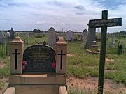
Jack Howe's gravesite in Blackall cemetery
-
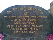
Gravestone memorial for Jack Howe in Blackall cemetery


Economy
There are a number of homesteads in the locality:
- Acton (25°27′33″S 145°25′48″E / 25.4591°S 145.4299°E)
- Alamay (24°36′03″S 145°00′06″E / 24.6007°S 145.0017°E)
- Alice Downs (24°16′15″S 145°29′21″E / 24.2709°S 145.4893°E)
- Allandale (24°20′58″S 145°55′02″E / 24.3495°S 145.9172°E)
- Alva (25°07′43″S 145°25′36″E / 25.1287°S 145.4268°E)
- Ansgrove (24°28′06″S 145°23′30″E / 24.4682°S 145.3918°E)
- Anthony (24°06′31″S 145°52′33″E / 24.1087°S 145.8758°E)
- Athol (24°29′40″S 145°11′22″E / 24.4944°S 145.1894°E)
- Avington (24°04′42″S 144°58′12″E / 24.0784°S 144.9700°E)
- Avondale (24°14′03″S 145°05′49″E / 24.2342°S 145.0969°E)
- Benalla (24°35′26″S 144°42′36″E / 24.5905°S 144.7099°E)
- Blairgowrie (24°31′16″S 144°55′45″E / 24.5211°S 144.9291°E)
- Bloomfield (24°38′31″S 145°19′18″E / 24.6420°S 145.3218°E)
- Boorara (24°02′10″S 145°41′10″E / 24.0362°S 145.6860°E)
- Brides Creek (25°01′36″S 145°26′53″E / 25.0267°S 145.4481°E)
- Bridesdale (24°56′20″S 145°24′59″E / 24.9389°S 145.4164°E)
- Caranna (25°24′04″S 145°20′30″E / 25.4010°S 145.3416°E)
- Carlow (24°51′50″S 145°26′50″E / 24.8640°S 145.4472°E)
- Champion (24°13′32″S 145°52′53″E / 24.2255°S 145.8813°E)
- Clarendon (24°14′36″S 145°13′20″E / 24.2432°S 145.2221°E)
- Colart (24°40′25″S 145°38′47″E / 24.6736°S 145.6463°E)
- Coolatai (24°53′34″S 145°30′59″E / 24.8929°S 145.5165°E)
- Cootabynia (25°07′32″S 145°13′05″E / 25.1255°S 145.2181°E)
- Coreen (24°18′37″S 145°11′59″E / 24.3104°S 145.1997°E)
- Devenish (24°17′58″S 146°14′07″E / 24.2994°S 146.2353°E)
- Duck Creek (24°37′01″S 145°44′21″E / 24.6169°S 145.7391°E)
- Dumfries (24°59′47″S 145°33′44″E / 24.9963°S 145.5622°E)
- Duneira (24°32′32″S 145°34′11″E / 24.5422°S 145.5698°E)
- Duthie Park (24°27′05″S 145°48′31″E / 24.4513°S 145.8085°E)
- Eastwood (24°42′14″S 145°25′14″E / 24.7040°S 145.4205°E)
- Effra (24°43′00″S 145°39′30″E / 24.7167°S 145.6583°E)
- Erne (24°21′03″S 145°58′57″E / 24.3508°S 145.9826°E)
- Five Mile (24°24′08″S 145°23′16″E / 24.4021°S 145.3879°E)
- Flemington (24°43′23″S 145°22′19″E / 24.7230°S 145.3720°E)
- Forest Hill (25°05′58″S 145°35′20″E / 25.0994°S 145.5888°E)
- Forest Park (24°31′05″S 145°34′12″E / 24.5180°S 145.5699°E)
- Gowan (25°01′11″S 145°18′10″E / 25.0196°S 145.3028°E)
- Gowan Hills (24°14′37″S 144°42′09″E / 24.2437°S 144.7025°E)
- Harden Park (24°20′31″S 145°45′32″E / 24.3419°S 145.7588°E)
- Henley Park (24°06′27″S 145°55′04″E / 24.1075°S 145.9179°E)
- Homebush (24°49′40″S 145°17′05″E / 24.8279°S 145.2848°E)
- Idalia Stud (24°33′09″S 144°51′40″E / 24.5525°S 144.8610°E)
- Inverness (24°35′57″S 145°26′06″E / 24.5991°S 145.4350°E)
- Juray (24°26′24″S 144°50′12″E / 24.4401°S 144.8366°E)
- Koondoo (24°57′19″S 145°14′57″E / 24.9552°S 145.2492°E)
- La Plata (24°33′23″S 145°35′25″E / 24.5565°S 145.5902°E)
- Lambert (25°23′29″S 145°24′54″E / 25.3915°S 145.4151°E)
- Lancevale (23°54′37″S 145°53′28″E / 23.9102°S 145.8911°E)
- Lilyveil (24°36′30″S 144°54′22″E / 24.6082°S 144.9062°E)
- Linden (24°25′14″S 145°11′04″E / 24.4206°S 145.1844°E)
- Lisburne (25°16′17″S 145°05′59″E / 25.2713°S 145.0997°E)
- Lisgool (abandoned) (24°15′17″S 146°16′30″E / 24.2548°S 146.2751°E)
- Listowel Downs (25°12′26″S 145°13′48″E / 25.2072°S 145.2300°E)
- Lorne Peak (24°57′33″S 145°08′59″E / 24.9592°S 145.1497°E)
- Lowana (24°39′16″S 144°49′15″E / 24.6545°S 144.8208°E)
- Lynbrydon (25°16′31″S 145°14′22″E / 25.2753°S 145.2394°E)
- Malvern Hills (24°29′05″S 145°07′25″E / 24.4847°S 145.1235°E)
- Manoora (24°42′28″S 145°37′11″E / 24.7077°S 145.6198°E)
- Maree Downs (24°26′13″S 144°54′31″E / 24.4370°S 144.9087°E)
- Maryvale Springs (24°03′26″S 145°54′28″E / 24.0571°S 145.9079°E)
- Melrose (24°11′05″S 145°00′21″E / 24.1846°S 145.0059°E)
- Milparinka (24°26′49″S 145°47′50″E / 24.4469°S 145.7972°E)
- Milton Park (24°39′02″S 145°04′25″E / 24.6505°S 145.0735°E)
- Moorlands (24°23′49″S 145°04′10″E / 24.3969°S 145.0695°E)
- Morundah (24°40′55″S 144°52′15″E / 24.6819°S 144.8708°E)
- Mount Harden (24°47′05″S 144°51′12″E / 24.7847°S 144.8534°E)
- Navena (24°13′57″S 145°33′08″E / 24.2325°S 145.5523°E)
- Neverfail (24°06′18″S 146°04′24″E / 24.1051°S 146.0732°E)
- Northampton Downs (24°33′37″S 145°47′12″E / 24.5604°S 145.7866°E)
- Northampton Stud (24°27′24″S 145°40′05″E / 24.4566°S 145.6681°E)
- Norwood (24°20′38″S 145°18′34″E / 24.3439°S 145.3094°E)
- Nudgee (24°47′29″S 145°32′16″E / 24.7915°S 145.5378°E)
- Paradise Downs (24°19′16″S 145°39′06″E / 24.3210°S 145.6516°E)
- Pentwyn (24°35′36″S 145°39′03″E / 24.5933°S 145.6509°E)
- Prairie Downs (24°13′57″S 145°00′41″E / 24.2326°S 145.0113°E)
- Purtora (24°19′40″S 146°06′13″E / 24.3277°S 146.1035°E)
- Ravensbourne (24°50′40″S 145°36′48″E / 24.8445°S 145.6134°E)
- Rivington (24°29′01″S 144°45′31″E / 24.4836°S 144.7586°E)
- Romulus (24°45′01″S 145°41′17″E / 24.7504°S 145.6881°E)
- Ryandale (24°01′57″S 145°46′58″E / 24.0324°S 145.7829°E)
- Selvister (24°27′27″S 145°12′52″E / 24.4574°S 145.2145°E)
- South Terrick (24°51′50″S 145°03′27″E / 24.8639°S 145.0574°E)
- Springleigh (24°33′42″S 144°43′09″E / 24.5617°S 144.7192°E)
- Stratavon (24°03′42″S 144°50′41″E / 24.0618°S 144.8447°E)
- Stratford (23°52′02″S 145°47′50″E / 23.8673°S 145.7971°E)
- Sumnervale (24°54′16″S 145°34′18″E / 24.9044°S 145.5717°E)
- Sydenham (24°02′14″S 145°59′07″E / 24.0372°S 145.9854°E)
- Tarbarah (24°45′11″S 144°58′54″E / 24.7530°S 144.9816°E)
- Tarves (24°13′45″S 145°19′04″E / 24.2291°S 145.3179°E)
- Terrick Terrick (24°44′11″S 145°04′27″E / 24.7363°S 145.0741°E)
- Thornleigh (24°19′26″S 144°54′31″E / 24.3238°S 144.9087°E)
- Tilbury (24°07′20″S 145°42′32″E / 24.1221°S 145.7089°E)
- Valparaiso (24°18′03″S 146°08′36″E / 24.3009°S 146.1432°E)
- Warringah (24°48′40″S 145°01′45″E / 24.8112°S 145.0293°E)
- Westhill (24°14′40″S 145°35′58″E / 24.2444°S 145.5994°E)
- Woodbine (24°20′28″S 145°26′52″E / 24.3412°S 145.4478°E)
Education
Blackall State School is a government primary and secondary (Prep-12) school for boys and girls at the corner of Hawthorne Street and Shamrock Street (24°25′32″S 145°28′11″E / 24.4256°S 145.4696°E). In 2012, there were 152 students enrolled with 14.5 teachers. In 2018, the school had an enrolment of 111 students with 13 teachers (11 full-time equivalent) and 17 non-teaching staff (10 full-time equivalent).
St Joseph's Catholic Primary School is a Catholic primary (Kindergarten-6) school for boys and girls at 109 Thistle Street (24°25′12″S 145°27′35″E / 24.4200°S 145.4597°E). In 2018, the school had an enrolment of 69 students with 7 teachers (5 full-time equivalent) and 4 non-teaching staff (2 full-time equivalent).
Notable people
- Ashley Adams – Paralympic shooter
- Bonny Barry – Politician
- Jack "Jackie" Howe – Shearer
- Edgar Towner – Recipient of the Victoria Cross
Images for kids
-
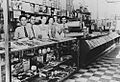
A thriving Greek cafe in the 1930s in Blackall, Queensland
-
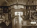
Interior view of the Logos Brother's Central Cafe at Blackall, Queensland


