
Blackburn facts for kids
Quick facts for kids Blackburn |
|
|---|---|
| Town | |
 From top left, Blackburn Town Hall and its extension, Blackburn Cathedral, St Silas' Church, Blackburn railway station and Skyline of Blackburn with St Silas' Church and the Masjid e Tauheedul Islam Mosque. |
|

Blackburn
|
|
| Population | 120,500 |
| • Density | 11,114/sq mi (4,291/km2) |
| Demonym | Blackburnian |
| OS grid reference | SD685277 |
| • London | 184 mi (296 km) SSE |
| Unitary authority | |
| Ceremonial county | |
| Region | |
| Country | England |
| Sovereign state | United Kingdom |
| Post town | BLACKBURN |
| Postcode district | BB1, BB2 |
| Dialling code | 01254 |
| Police | Lancashire |
| Fire | Lancashire |
| Ambulance | North West |
| EU Parliament | North West England |
| UK Parliament |
|

Blackburn is a large industrial town located in the Blackburn with Darwen borough in Lancashire, England. The town is north of the West Pennine Moors on the southern edge of the Ribble Valley, 8 mi (13 km) east of Preston and 21 mi (34 km) north-northwest of Manchester. Blackburn is the administrative centre of the Blackburn with Darwen unitary authority with the neighbouring town of Darwen.
Contents
History
Toponymy

Blackburn was recorded in the Domesday Book as Blacheborne in 1086. The origins of the name are uncertain. It has been suggested that it may be a combination of an Old English word for bleach, together with a form of the word "burn", meaning stream, and may be associated with a bleaching process. Alternatively, the name of the town may simply mean "black burn", or "black stream".
Prehistory
There is little evidence of prehistoric settlement in the Blakewater valley, in which Blackburn developed. Evidence of activity in the form of two urn burials has been discovered from the Bronze Age in the hills around Blackburn. In 1879, a cinerary urn was discovered at a tumulus at Revidge, north of the town; another was excavated in 1996 at Pleasington Cemetery, west of the town, by gravedigger Grant Higson. The presence of a sacred spring—perhaps in use during the Iron Age—provides evidence of prehistoric activity in the town centre, at All Hallows Spring on Railway Road.
Roman era
Blackburn is located where a Roman military road crossed the river Blakewater. The road linked Bremetennacum Veteranorum (Ribchester) and Mamucium (a major Roman fort that occupied Castlefield in Manchester). The route of the road passed east of Blackburn Cathedral and probably crossed the river in the Salford neighbourhood just east of the modern town centre. It is not clear whether the road predated the settlement.
- Roman Temple Spring at All Hallows
All Hallows Spring was excavated in early archaeology in 1654 and found to contain an inscribed stone commemorating the dedication of a temple to Serapis by Claudius Hieronymus, legate of Legio VI Victrix.
Middle Ages

Christianity is believed to have come to Blackburn by the end of the 6th century, perhaps in 596 as there is a record of a "church of Blagbourne" in that year, or 598 AD. The town was important during the Anglo-Saxon era when the Blackburnshire Hundred came into existence as a territorial division of the kingdom of Northumbria.
The name of the town appears in the Domesday Book as Blachebourne, a royal manor during the days of Edward the Confessor and William the Conqueror. Archaeological evidence from the demolition of the medieval parish church on the site of the cathedral in 1820 suggests that a church was built during the late 11th or early 12th century. A market cross was also erected nearby in 1101. The manor came into the possession of Henry de Blackburn, who divided it between his two sons. Later, one half was granted to the monks of Stanlow Abbey and this moiety was subsequently granted to the monks of Whalley Abbey. During the 12th century, the town's importance declined as Clitheroe became the regional centre. In addition to a settlement in the town centre area, there were several other medieval domiciles nearby.
Industrial Revolution and textiles

Textile manufacturing in Blackburn dates from the mid-13th century, when wool produced locally by farmers was woven in their homes. Flemish weavers who settled in the area in the 14th century developed the industry. By 1650 the town was known for the manufacture of blue and white "Blackburn checks", and "Blackburn greys" became famous not long afterwards. By the first half of the 18th century textile manufacture had become Blackburn's main industry. From the mid-18th to the early 20th century Blackburn evolved from a small market town into "the weaving capital of the world", and its population increased from less than 5,000 to over 130,000.
John Bartholomew's Gazetteer of the British Isles provides a profile of Blackburn in 1887:
Blackburn. parl. and mun. bor., parish and township, NE. Lancashire, 9 miles (14 km) [14 km] E. of Preston and 210 miles (340 km) [340 km] NW. of London by rail – par., 48,281 ac., pop. 161,617; township, 3681 ac., pop. 91,958; bor., 6974 ac., pop. 104,014; 4 Banks, 2 newspapers. Market-days, Wednesday and Saturday. It is one of the chief seats of cotton manufacture, besides producing calico, muslin, &c., there being over 140 mills at work. There are also factories for making cotton machinery and steam-engines. B. has been associated with many improvements in the mfr. of cotton, among which was the invention (1767) of the "spinning jenny" which was invented in nearby Oswaldtwistle by James Hargreaves, who died in 1770. There are several fine churches and public buildings. A Corporation Park (50 ac. in area) is on the outskirts of the town. Several lines of railway converge here, and pass through one principal station belonging to the Lancashire and Yorkshire Ry. Co. B. returns 2 members to Parliament.

From around 1750, cotton textile manufacturing expanded rapidly. Supplied with cotton by merchants, and paid by the piece, cottagers spun cotton into thread and wove it into cloth. The merchants arranged for cloth to be bleached and dyed.
After 1775, spinning mills were built in the town. Early mills were warehouse conversions; the first purpose-built spinning mill was constructed in 1797 and by 1824 there were 24. The number of spindles reached 2.5 million by 1870 and spinning mills were constructed up to that time – 24 since 1850. Spinning declined between 1870 and 1900 as the sector transferred to south Lancashire.
In 18th century Blackburn, weaving was primarily undertaken by handloom weavers working from their own cottages. However, as powerlooms were introduced into the mills after 1825, the percentage of handloom weavers began to decline and this occurred more rapidly in areas closer to the town. Handloom weavers continued to make up a sizable portion of the workforce in outlying rural areas. The last handloom shop in Blackburn closed in 1894.
Improvements to the power loom in the early 1840s, and the construction of a railway line in 1846, led to greater investment in power looms in Blackburn in the second half of that decade. The railway brought opportunities for expansion of the cotton trade, and in subsequent decades many new mills were constructed: between 1850 and 1870, 68 weaving-only and four combined weaving/spinning mills were built and nine weaving mills were built per decade between 1870 and 1890.

Improvements in power loom efficiency meant that weaving, the primary source of wealth and income for handloom weavers, began to transfer from the cottage industry to factories. This led to high rates of unemployment: according to figures published in March 1826, some 60% of all handloom weavers in Blackburn and Rishton, Lower Darwen and Oswaldtwistle were unemployed. High unemployment led to the Lancashire weavers' riots. At 3:00 pm on 24 April 1826 a mob arrived in Blackburn after attacking powerlooms in Accrington. Proceeding to Bannister Eccles' Jubilee Factory on Jubilee Street, the mob destroyed 212 powerlooms in the space of 35 minutes. They then turned their attention to John Houghton and Sons' Park Place factory, located nearby, and destroyed another 25 looms, before seeking more machinery to attack. The crowd began to disperse at around 6:00 pm, troops having arrived at 3:30 pm to try to quell the rioting.
Decline of the cotton industry
In 1890, Blackburn's Chamber of Commerce recognised that the town was over-dependent on the cotton industry, warning of the dangers of "only having one string to their bow in Blackburn". The warning proved prophetic when, in 1904, a slump hit the cotton industry and other industries dependent on it, such as engineering, brewing and building. In 1908, another slump saw 43 mills stop production and a quarter of the town's looms lay idle.

Suspension of trade with India during the First World War resulted in the expansion of colonial British India's cotton industry at the expense of Britain's, and the imposition of an 11% import tariff by the colonial British Government led to a dramatic slump in trade in 1921, a situation which worsened in 1922 after the Indian Government raised the tariff to 14%. This caused the number of stopped mills to increase to 47, with 43,000 looms lying idle. Two years into the slump, Foundry and Limbrick Mills became the first to close permanently. Not long afterwards, in 1926, the General Strike saw production suspended at half the town's mills and 12,000 unemployed. There was another slump in 1928, and another strike in 1929 after employers requested a 12% wage cut; 40,000 cotton workers struck for a week and eight mills closed, making 28 closures in six years. By the start of 1930, 50 mills had shut and 21,000 people were unemployed. A financial crisis in 1931 led to 24,000 unemployed, with 1,000 houses and 166 shops lying empty in the town. A total of 26 mills closed down between 1930 and 1934.
The industry experienced a short post-war boom between 1948 and 50, during which sales increased, industry training methods improved and automatic looms were introduced which allowed a single weaver to control 20 to 25 looms. Loom sheds were rebuilt to house new, larger looms. Despite the post-war boom, the cotton industry continued to decline and only 25% of the town's population were employed in textiles by 1951; this : this figure had stood at 60% up to the beginning of the Great Depression in 1929. In 1952 the number of weavers fell from 10,890 to 9,020. By 1955 more cloth was imported from India than was exported and between 1955 and 1958 another 16 mills closed. In 1959, due partly to the re-organisation of the textile industry as a result of the Textiles Act, another 17 mills closed. By 1960 there were 30 mills operating in Blackburn.
Closures continued in the 1960s with The Parkside, Fountains, Malvern and Pioneer Mills shutting in 1964. In 1967 the Eclipse Mill at Feniscowles closed, unable to compete with imported cloth sold at nine pence cheaper per yard than the mill could produce. By the end of that year there were 26 mills operating. The 1970s saw further closures, and the number of textile workers in Blackburn reduced to 6,000 by January 1975, the year in which the Albion and Alston mills stopped production with the loss of 400 jobs. In 1976 there were 2,100 looms in operation in the town, compared with 79,405 in 1907.
Brewing industry
In 1807, the Daniel Thwaites & Co brewery was established; the company is still in business today.
In 1927, Matthew Brown & Co. relocated to the town's Lion Brewery, on Coniston Road, following their acquisition of local brewer Nuttall & Co. Matthew Brown was the subject of a hostile takeover by Scottish & Newcastle Breweries in 1987, and ceased brewing in 1991.
Geography
| Weather chart for Blackburn | |||||||||||||||||||||||||||||||||||||||||||||||
|---|---|---|---|---|---|---|---|---|---|---|---|---|---|---|---|---|---|---|---|---|---|---|---|---|---|---|---|---|---|---|---|---|---|---|---|---|---|---|---|---|---|---|---|---|---|---|---|
| J | F | M | A | M | J | J | A | S | O | N | D | ||||||||||||||||||||||||||||||||||||
|
70
6
1
|
50
7
1
|
60
9
3
|
50
12
4
|
60
15
7
|
70
18
10
|
70
20
12
|
80
20
12
|
70
17
10
|
80
14
8
|
80
9
4
|
80
7
2
|
||||||||||||||||||||||||||||||||||||
| temperatures in °C precipitation totals in mm |
|||||||||||||||||||||||||||||||||||||||||||||||
|
Imperial conversion
|
|||||||||||||||||||||||||||||||||||||||||||||||
At 53°44′41″N 2°28′37″W / 53.74472°N 2.47694°W (53.7449°, −2.4769°), and 184 miles (296 km) north-northwest of London, Blackburn stands 122 metres (401 ft) above sea level, 8.9 miles (14.3 km) east of Preston and 21 miles (34 km) north-northeast of Manchester. The Ribble Valley and West Pennine Moors lie to the north and south respectively. Blackburn experiences a temperate maritime climate, like much of the British Isles, with relatively cool summers and mild winters. There is regular but generally light precipitation throughout the year.
Although the city of Preston, the administrative centre for Lancashire, is located about 9.2 miles (15 km) to the west, Blackburn is the largest municipality in what is known as East Lancashire. The town is bounded on other sides by smaller towns, including Accrington to the east and Darwen to the south. Blackburn with Darwen forms a unitary authority. The village of Wilpshire, is 2+1⁄2 miles (4 km) north of Blackburn, and is partly contiguous (development-touching) however in the Ribble Valley local government district. Other nearby villages are Langho, approximately 1.2 miles (2 km) north-east, and Mellor to the north west.
The small towns of Rishton, to the east, and Great Harwood, to the north east, are both in the local government district of Hyndburn. 11 miles (18 km) further to the east lies the town of Burnley.
Geology and terrain


Located in the midst of the East Lancashire Hills, some areas of the town are characterised by steep slopes. The town centre centres in a plain of 91–110 m above sea level surrounded by hills. The Revidge to the north can be reached via a steep climb up Montague Street and Dukes Brow to reach a peak of 218 metres (715 ft) above sea level.
To the west, the wooded Billinge Hill in Witton Country Park is 245 metres (804 ft) high, while Royal Blackburn Hospital is situated to the east of the town at a vantage point of 202 metres (663 ft). These figures can be considered in the context of other hills and mountains in Lancashire, including Great Hill at 456 metres (1,496 ft), Winter Hill at 456 metres (1,496 ft), Pendle Hill at 557 metres (1,827 ft) and Green Hill at 628 metres (2,060 ft).
The River Blakewater, which gives its names to the town, flows down from the moors above Guide and then through the areas of Whitebirk, Little Harwood, Cob Wall and Brookhouse to the town centre. The river is culverted and runs underground in the town centre, under Ainsworth Street and between Blackburn Cathedral and the Boulevard. On the western side of the town centre the Blakewater continues through the Wensley Fold area before joining the River Darwen outside Witton Country Park; the Darwen flows into the River Ribble at Walton-le-Dale.
The geology of the Blackburn area yields numerous resources which underpinned its development as a centre of manufacturing during the Industrial Revolution. Mineable coal seams have been used since the mid-late 16th century. The Coal Measures in the area overlie the Millstone Grit which has been quarried in the past for millstones and, along with local limestone deposits, used as a construction material for roads and buildings. In addition, there were deposits of iron ore in the Furness and Ulverston districts.
The Blackburn area was subjected to glaciation during the Pleistocene ice age, and the sandstone-and-shale bedrock is overlain in much of the area by glacial deposits called till (which is also called "boulder clay") of varying thickness up to several tens of feet. Glacial outwash (sand and gravel) also occur in small patches, including along Grimshaw Brook.
Demography
At the time of the UK Government's 2001 census, Blackburn, defined as an urban area, had a population of 105,085 and a population density of 11,114/sq mi (4,291/km2). According to further statistics from the same census, this time defining Blackburn as a Westminster parliamentary constituency, the population was 69.22 per cent White British (national average for England 89.99 per cent) with significant Indian (14.31 per cent) and Pakistani (11.45 per cent ) ethnic minorities. 12.33 per cent of the population was born outside the European Union. In terms of religion, 57.53 per cent of residents were Christian (average for England 71.74 per cent), 25.74 per cent Muslim (average for England 3.1 per cent) and 15.98% no religion or not stated.
With regard to the economic activity of those aged 16–74, the 2001 Census indicates that 33.93 per cent were full-time employees (average for England 40.81 per cent), 11.72 per cent part-timers, 5.97 per cent self-employed (average for England 8.32 per cent), and 4.5 per cent unemployed (average for England 3.35 per cent).
The 2001 census also records the social grade of the constituency's 72,418 people aged 16 and over: using the NRS social grades system, 10,748 were classed as AB (higher and intermediate managerial/administrative/professional), 17,514 as C1 (supervisory, clerical, junior managerial/administrative/professional), 11,691 as C2 (skilled manual workers), 19,212 as D (semi-skilled and unskilled manual workers), and 13,253 as E (on state benefit, unemployed, lowest grade workers).
Additionally, Blackburn with Darwen Borough Council manages a site for Gypsies and travellers, in the Ewood area of the town.
The 2011 census showed that there was an increase in the number of people of ethnic minorities living within the Blackburn with Darwen area. Results showed that 31 per cent of people in the area were of an ethnic minority background, with 66.5 per cent defined as white British. This equates to roughly 45,500 people within Blackburn with Darwen being of a minority ethnic group – a level three times greater than the average across Lancashire and the rest of the region.
In 2011 Blackburn had 117,963 residents, of whom:
- 62.7% White (60.0% White British)
- 34.3% Asian
- 0.7% Black
There is a distinct contrast between different areas with ethnic groups due to segregation. Areas south and west of the town centre such as Ewood have an indigenous majority, with all wards in the area being more than 85 per cent White British. In contrast, most wards north and east of the town centre have an Asian majority, but also a small but increasing community of people from mainland Europe.
Transport
The Leeds and Liverpool Canal runs through Blackburn from Feniscowles in the SW to Whitebirk in the NE, skirting the town centre to the east of Blackburn railway station. This important early industrial artery arrived in 1810 and became the chief focus for industrial growth in the 19th century, with raw cotton imported via Liverpool. While it suffered neglect in the wake of the area's industrial decline, the Blackburn stretch has benefited from a number of regeneration projects since the 1990s. British Waterways residential moorings are to be found at Finnington Lane Bridge on the western edge of the borough.

The M65 motorway passes to the south of Blackburn. It runs from Colne, about 17 mi (27 km) northeast of Blackburn, to a point close to the village of Lostock Hall near Preston, about 12 mi (19 km) west. Junction six of the motorway is located at the eastern edge of Blackburn, near the Intack area; junctions five and four are located to the south, near the village of Guide and the Lower Darwen area respectively; and junction three is located at the south-western edge of the town, close to the Feniscowles area. The M65 links Blackburn to the national motorway network, connecting to junction nine of the M61 and junction 29 of the M6.
Other major roads in and around Blackburn include the A666 and the A677. The A666 runs from the A59 near the village of Langho, some 3+3⁄4 mi (6 km) north-west of Blackburn. It passes through the town centre and continues south through the towns of Darwen and Bolton, then south-west to the town of Pendlebury, near Manchester, where it joins the A6 at Irlams o' th' Height. The A677 runs from the east part of Blackburn, about 1+1⁄2 mi (2.5 km) from the centre. It passes through the centre of the town and continues to the western outskirts. It then heads north-west to the village of Mellor Brook before continuing west towards the city of Preston. It joins the A59 about 5+1⁄2 miles (9 km) west of Blackburn, about halfway between Blackburn and Preston. Barbara Castle Way (named after the former local MP) runs from Montague Street to Eanam Roundabout, passing close to the town centre as part of the A6078 town centre orbital route.
Blackburn's newly redeveloped railway station in the town centre is served by Northern. Services to Manchester Victoria station typically take around 50 minutes. The station also hosts East Lancashire Line services eastwards to Burnley, Colne and Leeds, and westwards to Preston.
Blackburn's new bus station in Ainsworth Street opened in May 2016. A new interchange was built outside the station as part of the Cathedral Quarter redevelopment, where all buses continue to Blackburn Bus Station. Manchester Airport, the busiest airport in the UK outside London, is the nearest airport to Blackburn with scheduled flights, about 28 mi (45 km) southeast of the town.
Landmarks
Cathedral

Blackburn Cathedral was formerly St Mary's Parish Church. St Mary's was reconsecrated in 1826 on the site of the previous church that had stood for several hundred years. In 1926 the Diocese of Blackburn was created and the church gained cathedral status. Blackburn was selected above other locations for the 'new wave' of Archbishop Temple's cathedrals because of its then excellent public transport infrastructure – the cathedral stands next to the bus and railway station. Between the 1930s and 1960s an enlarged cathedral was built using the existing building as the nave. Six of the cathedral's bells were cast in 1737 and are claimed to have been cast from even older bells. An image of the cathedral is used behind BBC interviews held in Blackburn, which are filmed at BBC Radio Lancashire on Darwen Street, opposite the cathedral.
Ewood Park
The ground was officially opened in AprIl 1882. Work on the current, redeveloped, all-seater stadium got underway in February 1993 when the old Darwen End stand was demolished. This stand, together with the old Blackburn End stand, was then redeveloped before the Nuttall Street stand was also demolished ready for redevelopment in January 1994. Almost two years later, on 18 November 1995, the newly redeveloped Ewood Park was officially opened. With a capacity of 31,367, the facility comprises four sections: the Darwen End, Riverside Stand (named as such because it stands practically on the banks of the River Darwen), Blackburn End, and Jack Walker Stand, which is named after Blackburn industrialist and club supporter, Jack Walker. The stadium also houses conference and banqueting facilities and was recently the setting for a new Guinness World Record, when a 1 tonne Chicken Samosa was made in recognition of club owners Venkys.

Queen Victoria's statue
Blackburn's statue of Queen Victoria is located next to the cathedral grounds overlooking the bus station. Victoria's fourth daughter, Princess Louise, Duchess of Argyll, unveiled the statue on 30 September 1905. It was sculpted by Australian sculptor Sir Bertram McKennal out of white Sicilian marble and stands on a grey granite plinth. The statue is 11 feet (3.4 m) high and weighs 9 long tons (9.1 t), while the plinth is 14 feet (4.3 m) high and weighs 30 long tons (30.5 t).
Town hall

The construction of Blackburn's original, Italian renaissance style town hall was completed in 1856 at a cost of £35,000, equivalent to about £1.5 million as at 2008. The architect was James Paterson and the contractors were Richard Hacking and William Stones. It originally housed a police station with 18 cells, a large assembly room, and a council chamber. A tower block extension was constructed in 1969 at a cost of £650,000, equal to about £6.6 million as at 2008. The tower block is not strictly an extension to the earlier building: the two buildings are connected only by an elevated, enclosed footbridge. The tower block was 198 feet (60 m) high and the top was 545 feet (166 m) 9 inches (23 cm) above sea-level when built, although it has since been re-clad and these figures may have altered slightly. The two buildings are known locally as the new town hall and old town hall respectively.

Technical School
The foundation stone of the Technical School building was laid on 9 May 1888 by the Prince and Princess of Wales; the building was completed towards the end of 1894. It is built in the Northern Renaissance style and has a slate roof, an attic, a basement, and two intermediate storeys. Made mainly of red brick and yellow terracotta, it is profusely decorated and features ornate gables, a round arched entrance with angle turrets and balcony above, and a frieze below the top storey with panels depicting art and craft skills. The Technical School is a grade II listed building and is now part of Blackburn College. Prince Charles- The Prince of Wales placed a time capsule into the wall of the college during his visit to Blackburn. The college is celebrating its 125th anniversary in 2013.
Other landmarks

The Wainwright Bridge was opened in June 2008. The £12 million bowstring arch bridge crosses the East Lancashire and Ribble Valley railway lines west of the town centre and forms part of the A6078 Town Centre Orbital Route. The bridge is named after Alfred Wainwright following a vote by the townspeople. Blackburn Arena, which houses an ice rink and is home to the Blackburn Hawks ice hockey team, opened in 1991.
Blackburn railway station features a 24 foot (7.3 m) mural by Ormskirk-based contemporary artist Stephen Charnock. It depicts eight famous faces associated with the town, including Mohandas Gandhi, who visited nearby Darwen in 1931. The station was renovated in 2000. BBC Radio Lancashire has its studios on Darwen Street in the town centre. Thwaites Brewery, which produces cask ale, has had a position in the centre of the town since 1870. There is also King George's Hall, which is an arts and entertainment centre and Thwaites Empire Theatre. A section of the Leeds and Liverpool Canal runs through the town. St Anne's Roman Catholic Church is also situated in the centre of the town, is a Lombard Romanesque church, built in 1926, destroyed by arson in 2002 and rebuilt in 2004.
Parks

Corporation Park, to the northwest of the town centre, was built on 20 hectares (50 acres) of land purchased from Joseph Feilden, lord of the manor, for £50 per 1 acre (0.40 ha) in 1855. The park officially opened on 22 October 1857, with shops and mills closing for the day, church bells ringing, and flags flying from public buildings. Railway companies claimed 14,000 people travelled to the town for the opening. A conservatory was opened in the park on 16 May 1900. Within Corporation Park is the Blackburn War Memorial which commemorates people who lost their lives in World War I and World War II. The towns annual Armistice parade concludes at the war memorial.
The town's Queen's Park was opened in June 1887, having been laid out at a cost of £10,000 on land acquired by Blackburn Corporation from the Ecclesiastical Commissioners in 1882. It originally had two bowling greens, two tennis courts, a lake of over 1.2 hectares (3 acres), a children's paddling pool, a bandstand, and a refreshment room. Two additional bowling greens and a pavilion were added in 1932.

Witton Country Park is a 190-hectare (480-acre) space to the west of the town. The land was purchased in 1946 and was the ancestral home of the Feilden family. It is larger than all the town's other parks and playing fields put together. Witton Park High School is located within the park, as are three astroturf football pitches and a full-size athletic track, which is home to the Blackburn Harriers. The Blackburn model aircraft club also use the park for flying radio controlled aircraft. Pleasington cemetery and crematorium are located on the park's outer edges.
Roe Lee Park, in the north of the town, was opened on Wednesday 30 May 1923 and was intended to commemorate the visit of George V. It was originally a 6.5-hectare (16-acre) site with five tennis courts and three bowling greens. The borough council's website describes the park as a 7-hectare (17-acre) "urban fringe park with bowling greens, kick around area and children's playground". In 2007, all four parks described above were winners of Green Flag awards.
Libraries
Blackburn Central Library is located in the town centre, close to the town hall, and is described as "the seventh most visited library in England." The library has various sections and facilities, including: an information and reference section, a media section, a community history section, a children's library, and a creche. An ICT training suite at the library has been named the "Bill Gates Room". Blackburn has smaller libraries serving the Mill Hill, Livesey and Roman Road parts of the town, as well as a mobile library service.
Cricket
Although Lancashire County Cricket Club play inter-county cricket at Old Trafford Cricket Ground, the town club at Alexandra Meadows on Dukes Brow is East Lancashire Cricket Club.
Blackburn Northern Cricket Club state they have recently leased the Ribchester Cricket Ground for their matches.
Twin towns
 Péronne, Somme, France
 Altena, Germany
 Tarnów, Poland
Economy
As of 2007, the town centre was subject to a multimillion-pound investment, and Blackburn with Darwen Council have already made some refurbishments and renovations of key public places, notably the Church Street area with its Grade II listed art deco Waterloo Pavilions complemented by street furniture and sculptures. As of 2006, The Mall Blackburn (formerly known as Blackburn Shopping Centre) was the main shopping centre in Blackburn with over 130 shops and 400 further outlets close by. in June 2011, Blackburn Market opened in a new site under the shopping centre and opened six days a week (Monday–Saturday). The previous market was based on the other side of Ainsworth Street. It first opened on this site in 1964, where there was a three-day market (Wednesday, Friday and Saturday) and the Market Hall (Monday–Saturday).
The town centre was expanded by construction of the Grimshaw Park retail development (including Blackburn Arena) in the 1990s. The adjacent Townsmoor Retail Park and Peel Leisure and Retail Park are more recent developments.
in May 2008, one of the town's most well-known shops, the shoe store Tommy Ball's, closed due to insolvency. The town's oldest store, Mercer & Sons, also closed after a decline in sales blamed on the credit crunch. It opened in 1840 and was originally an ironmonger, but it converted to selling toys, household goods and hardware. In January 2009 the directors of the company announced that the shop would close after a 30-day statutory consultation, unless they changed their minds or a buyer was found.
Markets continue to offer a wide range of local produce, such as Lancashire cheeses, tripe, Bowland beef and lamb. Walsh's Sarsaparilla stall decided not to join the move into the Mall shopping centre in 2011, and opens six days a week.
Major employers in Blackburn include: Blackburn College, Thwaites Brewery, BAE Systems (Samlesbury Aerodrome site, located at Samlesbury, northwest of Blackburn); Blackburn with Darwen Borough Council; and the East Lancashire Hospitals NHS Trust (based at the Royal Blackburn Hospital).
Drumstone Trade Park near the town centre has trade outlets.
Numerous business parks exist in and around the town.
Sport
Football

EFL Championship side Blackburn Rovers is based at the Ewood Park stadium. It was established in 1875, becoming a founder member of The Football League in 1888. In 1890 Rovers moved to its permanent home ground at Ewood Park. Until the formation of the Premier League in 1992, most of Blackburn Rovers' success was pre-1930, when they won the league twice and FA Cup six times. After finishing runners-up to Manchester United in 1993–1994, Rovers won the English Premier League the following year. In 2002 they won the League Cup.
Ice hockey
Blackburn has an Olympic-sized ice rink housed at the 3,200-seat Blackburn Arena. The arena is the home of the Blackburn Hawks and Lancashire Raptors ice hockey teams, both of which play in the English National Ice Hockey League.
Cricket
Although Lancashire County Cricket Club play inter-county cricket at Old Trafford Cricket Ground, the town club at Alexandra Meadows on Dukes Brow is East Lancashire Cricket Club.
Blackburn Northern Cricket Club states it has recently leased the Ribchester Cricket Ground for its matches.
Education
- See List of schools in Blackburn with Darwen
Secondary education in Blackburn is provided by nine state-funded schools and one private school. In 2005, Tauheedul Islam Girls' High School became the first Muslim state school in the North West. It had previously been an independent school. Since then Tauheedul Islam Boys' High School has been established and Queen Elizabeth's Grammar School joined the state-funded sector.
The town also has a few special schools. St Thomas's and Sunnyhurst Pupil Referral Unit educates children unable to attend mainstream school for health reasons or other difficulties.
Over £25 million was invested in educational initiatives in Blackburn with Darwen in the late 2000s, including new schools, city learning centres and children's centres. Over 11,000 adults take part in some form of educational programme. Blackburn with Darwen council has twice had Beacon Status for education in the "Fostering School Improvement" and "Transforming the School Workforce" categories. Compared with 56.5 per cent nationally, 51.3 per cent of pupils in Blackburn with Darwen achieve grades A*–C. The average GCE/VCE A/AS and Equivalent Point Score per Student is 649.7, compared with 716.7 nationally.
Although the town's proportion of ethnic minorities is below 25%, in some schools the vast majority of pupils are from the ethnic minority population, whilst other schools are almost entirely white. This has been identified as a problem to racial integration in the town.
The independent school sector is represented by Westholme School and Jamiatul Ilm Wal Huda.
The two further education colleges in the town are Blackburn College and the sixth-form St. Mary's College. The town does not have a university, but some higher education courses for over 18s are provided by the East Lancashire Institute of Higher Education (ELIHE).
Notable people
Arts and music
- Tony Ashton (1946–2001), rock musician
- Michael Billington (1941–2005), actor star of UFO
- William Billington (1825–1884), writer, known as the "Blackburn Poet"
- Josephine Cox (1938–2020), fiction writer
- Ross Eccles (born 1937), contemporary artist; many of his paintings feature Blackburn and Lancashire scenes and landmarks
- Kathleen Ferrier (1912–1953), contralto
- Michael Gibson, (born 1980), television presenter and documentary director
- Barry Gray, composer, (1908–1984)
- Kathleen Harrison (1892–1995), actress
- Tez Ilyas (born 1983), stand-up comedian
- Russell Harty (1934–1988), broadcaster
- Ethel Carnie Holdsworth (born Ethel Carnie, 1886–1962), writer and feminist
- Lee Mack, (born 1968), actor/comedian
- Grace Davies, (born 1997), singer/songwriter
- Sarah Martin (born 1974), musician, member of Belle and Sebastian
- Ian McShane (born 1942), actor
- Tony O'Neill, (born 1978), author
- Steve Pemberton (born 1967), actor
- Wendi Peters (born 1968), actress
- Ronald Stevenson (1928–2015), Scottish composer
- Jeanette Threlfall (1821–1880), Christian hymnist and poet
- Debbie Travis (born 1960), television host
- Anthony Valentine (1939–2015), actor
- Diana Vickers, (born 1991), singer and actress
- Alfred Wainwright (1907–1991), guidebook author
- Jon Walmsley (born 1956) musician and actor
- Michael Winterbottom (born 1961), film maker
- William Woodruff (1916–2008), historian and author
Sport
- Gareth Ainsworth (born 1973), footballer and football manager
- Farakh Ajaib (born 1991), snooker player
- Iain Balshaw (born 1979), England rugby union player
- Bernard Cafferty (born 1934), chess player, author and translator
- Matt Derbyshire (born 1986), footballer for AC Omonia
- Anastasios Donis (born 1996), footballer for Stade Reims and Greece
- Keith Duckworth (1933–2005), motor-racing engine designer
- David Dunn (born 1979), footballer for Blackburn Rovers and England, then football coach
- Frank Fielding (born 1988), footballer for Millwall F.C.
- Carl Fogarty (born 1965), four time motorcycle World Superbike champion
- Joe Garner (born 1988), footballer for APOEL FC
- Will Greenwood (born 1972), England rugby union player
- Connor Mahoney (born 1997), footballer for Millwall F.C.
- Oliver Newby (born 1984), cricketer for Lancashire
- Geoffrey Phillips (born 1931), England cricketer
- Anthony Pilkington (born 1988), footballer for Cardiff City F.C.
- John Sumner (1936–2004), rock climber
- William Townley (1866–1950), footballer and coach
Sciences
- Timothy Leighton (born 1963), Ultrasonics and Underwater Acoustics professor, Institute of Sound and Vibration Research, University of Southampton
- Barbara Mawer (1936–2006), biochemist and medical researcher
- Noel Slater (1912–1973), mathematician and astronomer
Images for kids
-
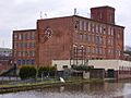
Albion Mill photographed in 2008. The mill ceased production in 1975 and was demolished in 2010.
-
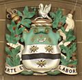
Arms of the former Blackburn Borough Council on display in the Town Hall.

See also
 In Spanish: Blackburn para niños
