
Blackcap, East Sussex facts for kids
.jpg)
Blackcap is a National Trust owned area of countryside on the peak of the South Downs, just south east of the village of Plumpton in East Sussex, England. It is also mainly part of the Clayton to Offham Escarpment SSSI. The reserve contains the hills of Blackcap 206 metres (676 ft) in the parish of East Chiltington, Mount Harry 196 metres (643 ft) in the parish of Hamsey and the wooded area of Ashcombe Bottom in the parish of St John Without.
Walks can be taken starting low down by the road at the north, and then climbing steadily south up to the ridge, where there are views southwards. The flatter landscape is made up of scrubby open ground with chalk paths, surrounded by thickets (home to many songbirds including blue tits and common chaffinches). The steeper ground leading up to the ridge is low-density woodland. The top is very open, with patches of pine woodland and gorse bushes, and there is a triangulation point here.
The flat surrounding fields are grazed by sheep, and the surrounding hillsides are so stubbly and coarse that Exmoor ponies are brought in to graze them. Carrion crows often fly overhead, and the scrub is populated by rabbits. Roe deer come out when it is quiet to graze, hidden and protected by the surrounding thickets.
Images for kids
-
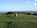
The peak of Blackcap
-
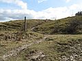
Bridleway crossing on the slope of Blackcap - geograph.org.uk - 1769476
-
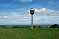
Beacon on Mount Harry - geograph.org.uk - 2045198
-
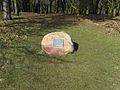
Plaque on Blackcap - geograph.org.uk - 1770519
-
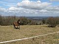
Ponies a long way from home - geograph.org.uk - 1770528


