
Blanchardstown facts for kids
Quick facts for kids
Blanchardstown
Baile Bhlainséir
|
|
|---|---|
|
Suburb (village core)
|
|

Clockwise from top: Fingal County Council's Civic Offices; Millennium Park; businesses in Blanchardstown during the COVID-19 pandemic
|
|

Blanchardstown
Location in Dublin

Blanchardstown
Location in Ireland
|
|
| Country | Ireland |
| Province | Leinster |
| County | Fingal |
| Elevation | 56 m (184 ft) |
| Population
(2006)
|
|
| • Urban | 68,156 |
| Time zone | UTC±0 (WET) |
| • Summer (DST) | UTC+1 (IST) |
| Eircode routing key |
D15
|
| Telephone area code | +353(0)1 |
| Irish Grid Reference | O055383 |
Blanchardstown (Irish: Baile Bhlainséir) is a large outer suburb of Dublin in the modern county of Fingal, Ireland. Located ten kilometres (6 mi) northwest of Dublin city centre, it has developed since the 1960s from a small village to a point where Greater Blanchardstown is the largest urban area in Fingal.
It is within the historical barony of Castleknock in the traditional County Dublin, as well as the Dublin 15 postal area and the Dublin West electoral constituency.
One of Ireland's largest shopping and leisure complexes — the Blanchardstown Centre and adjacent facilities — is located in the area.
Contents
History
Blanchardstown has grown up alongside its smaller neighbouring town, Castleknock. Both towns shared a common history until well into the 19th century, when their development diverged. The name Blanchardstown comes from the Blanchard family, who were granted their estate some time between 1250 and 1260. The name 'Blanchard' is thought to come from the old French word blanch, meaning white, and could refer to white or fair hair. The townland has an area of over 454 acres.
Blanchardstown was a rural village in western County Dublin until the late 1960s, when the first housing estates began to be developed. Blanchardstown developed in tandem with neighbouring settlement Castleknock, both of which grew rapidly from the early 1970s to the present. During the 1970s/80s, the village became subsumed into the suburban fabric of Dublin. The Institute of Technology, Blanchardstown (ITB) was established in 1999.
A criminal gang from Blanchardstown became notorious as "The Westies". They controlled the heroine trade in west Dublin. One of its leaders, Bernard Sugg, was shot in a pub in Blanchardstown in 2003, while the others were killed in Spain in 2004.
Ecclesiastical history
In the 19th century, the Roman Catholic parish of Blanchardstown encompassed much of the area now within the Dublin 15 postal district. Following the relaxation of the Penal Laws, it became possible for the Catholic adherents to consider the construction of additional churches and to repair the existing stock of religious buildings. Church authorities used the opportunity to implement the Tridentine reform which saw the parish as the basic unit of ecclesiastical organisation and the parish priest as the central figure within the parish.
The new parish priest of Blanchardstown in 1839, Fr Michael Dungan, oversaw the construction of a number of new churches, which are today independent parishes in their own right, and invited a number of religious communities to provide for the education of Catholic children. St Brigid's Church, Blanchardstown – not to be confused with a church of the Church of Ireland in nearby Castleknock – was constructed in 1837 upon the foundation of a church that had been built prior to 1731. It is the Mother church of 12 other churches constituted out of the parish over the following 156 years. They are:
- Chapelizod - "Nativity of the Blessed Virgin Mary" (separated from Blanchardstown 1883)
- Navan Road - "Our Lady Help of Christians" (separated from Chapelizod 1953)
- Castleknock - "Our Lady Mother of the Church" (separated from Blanchardstown 1976)
- Laurel Lodge / Carpenterstown - "St Thomas, the Apostle" (separated from Castleknock 1983)
- Porterstown - "St Mochta's" (separated from Castleknock 1986. The present church was constructed in 1890 as a Chapel of ease for Blanchardstown.)
- Corduff - "St Patrick's Church" (separated from Blanchardstown 1976)
- Mountview - "St Philip, the Apostle" (separated from Corduff 1979)
- Blakestown - "Church of Mary of the Servants" (separated from Corduff 1979)
-
-
- Huntstown - "Church of the Sacred Heart of Jesus" (separated from Blakestown 1981)
-
-
-
-
- Littlepace - "Chapel of Ease, Mary, Mother of Hope" (in the process of development since 2002)
-
-
- Hartstown - "St Ciarán' Church" (separated Blanchardstown 1979)
- Mulhuddart / Lady's Well - "St Luke, the Evangelist" (separated from Blanchardstown 1993)
Geography

Blanchardstown is just outside Dublin's M50 motorway ring road, slightly to the north of the tolled crossing of the River Liffey. The core of the suburb is the townland of the same name. It is bordered to the east by the suburb of Castleknock, to the west by Clonsilla/Ongar, to the north by Tyrellstown/Hollystown and to the south and south east by Porterstown/Diswellstown. The Royal Canal and the Dublin-Sligo railway line pass along the southern edge of Blanchardstown proper from east to west.
For the purposes of elections to Dáil Éireann, it is part of the Dublin West constituency which returns four TDs.
For the purposes of elections to Fingal County Council, the village is split between two local electoral areas (LEAs). They are Castleknock (4 councillors returned) and Mulhuddart (5 councillors returned).
Transport

Rail
There are three Irish Rail train stations in the wider Blanchardstown area: Castleknock, Coolmine and Clonsilla. Trains on the Maynooth/Longford line connect the city centre, at Dublin Connolly, Tara Street and Dublin Pearse stations, to Maynooth, Longford and Sligo. At Clonsilla station, the Dublin–Navan railway line connects Docklands railway station to Hansfield and Dunboyne.
Bus
Dublin Bus and Go-Ahead Ireland routes include 17A, 37, 38, 38A, 38B, 38C, 38D, 39, 39A, 39N, 40D, 70, 76A, 220, 236, 238, 239 and 270.
Two Nitelink bus routes also operate on Friday and Saturday nights to Tyrrelstown Route 39N and Dunboyne Route 70N. Express bus routes include service from Aston Quay and from Coolmine Railway Station to Ballycoolin Industrial Estate.
Ballycoolin Industrial Estate is served by a private bus company called AMC Ballycoolin, also known as Express Bus.
Bus Éireann services pass through Blanchardstown on Routes 105,109 and 111.
Features and facilities

- St Brigid's Roman Catholic Church is situated behind Main Street at Church Avenue. The foundation stone for the Church was laid on 13 October 1835 and the first Mass was celebrated there on 29 October 1837. The construction of the Church and its unusual Flemish spire was finally completed in 1863.
- Connolly Hospital
- Institute of Technology, Blanchardstown - a third level educational institute
- Blanchardstown Centre - Ireland's largest retail shopping centre, home to over 180 stores located to the north of the village
- WestEnd Shopping Park - a retail park located beside the Blanchardstown Centre.
- Carlton Hotel - a 4 Star Hotel north-west of the village, located at the Blanchardstown Centre.
- SuperValue, Main Street, Blanchardstown.
• National Aquatic Centre (NAC)- national indoor aquatics facility with a 50m swimming pool, diving pool, leisure pool and fitness centre. The centre hosted the 2003 Special Olympics World Summer Games and continues to host a number of international swimming events.
Sport
The National Sports Campus is located in Blanchardstown and includes the National Aquatic Centre, a major indoor aquatics facility with a 50m swimming pool, diving pool, leisure pool and aquapark, and fitness centre. The centre hosted the 2003 Special Olympics World Summer Games and a number of international swimming events since then.
There are several GAA clubs in the Blanchardstown area, including St. Brigids, Castleknock and St. Peregrines, Clonsilla. There are also a number of association football (soccer) clubs in the area.
Education

There are a number of primary schools (national schools) in Blanchardstown, including Scoil Bhríde (Cailiní) and Scoil Bhríde (Buacaillí) on Church Avenue, Sacred Heart of Jesus Primary School (Huntstown), Scoile Olilibheir (Coolmine), St Ciaran's Primary School (Hartstown), Mary Mother of Hope Primary School (Clonee), and St Phillip the Apostle Primary School (Mountview).
Second-level schools (secondary schools) serving the area include Blakestown Community School, Riversdale Community College, Hartstown Community School, and Coolmine Community School.
.jpg)
The Institute of Technology, Blanchardstown (part of TU Dublin) is a third-level institution with a campus on the Blanchardstown Road.
Notable people
- Joan Burton, former Labour TD, Tánaiste and government minister
- Jade Jordan, actor and author
- Siva Kaneswaran, musician with The Wanted
- William Mooney, cricketer
- Alan Moore, sports journalist
- John Troy, Roman Catholic Archbishop of Dublin
- Leo Varadkar, Fine Gael TD, Tánaiste and former Taoiseach
Images for kids
-
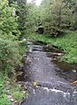
River Tolka by Connolly Memorial Hospital
-
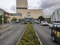
Main entrance to Connolly Hospital
-
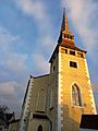
St Brigid's Church, Blanchardstown
-
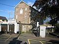
The former Carmelite Convent (now a business premises) in Blanchardstown
-
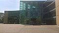
Fingal County Council civic offices, Blanchardstown
-
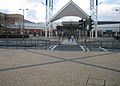
Blanchardstown Centre
-
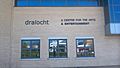
Draíocht Arts Centre
-
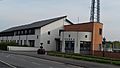
Blanchardstown Garda Station
-
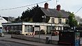
Shop on Blanchardstown's main street
.jpg)
.jpg)


.jpg)

.jpg)


