
Blaxland, New South Wales facts for kids
Quick facts for kids BlaxlandNew South Wales |
|||||||||||||||
|---|---|---|---|---|---|---|---|---|---|---|---|---|---|---|---|
Remains_of_Pilgrim_Inn_Blaxland-1.jpg)
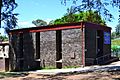
Remains of Pilgrim Inn, c. 1825
|
|||||||||||||||

Blaxland
Location in New South Wales
|
|||||||||||||||
| Population | 7,451 (2016 census) | ||||||||||||||
| Established | 1830 | ||||||||||||||
| Postcode(s) | 2774 | ||||||||||||||
| Elevation | 234 m (768 ft) | ||||||||||||||
| Location | |||||||||||||||
| LGA(s) | City of Blue Mountains | ||||||||||||||
| State electorate(s) |
|
||||||||||||||
| Federal Division(s) | Macquarie | ||||||||||||||
|
|||||||||||||||
Blaxland is a town in the Blue Mountains of New South Wales, Australia. Blaxland is located 65 kilometres west of Sydney in the local government area of the City of Blue Mountains. It is at an altitude of 234 metres and borders the townships of Glenbrook, Mount Riverview and Warrimoo.
Contents
History
Blaxland is named for Gregory Blaxland who along with William Lawson and William Wentworth, led the exploration that discovered a route over the Blue Mountains in 1813. Prior to 1879 the area was known as Wascoe.
The Pilgrim Inn was built c. 1825. It was a significant element in the area for some time, but eventually decayed. The remains, which are now adjacent to McDonald's, are heritage-listed.
The Rev. Joshua Hargrave became a major presence in the area in the early 20th. century, and a significant force in the growth of Blaxland as a village, especially south Blaxland. He built the first church in the area and, with his family and the Calver family, is associated with four homes that still survive: Tanfield in Hope Street, Menahne in Hope Street, Rosedale in View Street and Nardi in View Street. The homes are all heritage-listed.
Transport
Blaxland railway station is on the Blue Mountains Line of the NSW TrainLink intercity network. It is a disability-accessible station.
Services
- Blue Mountains Library branch, Hope Street
- Blaxland Fire Brigade falls under the jurisdiction of the statewide Rural Fire Service
Sport and Recreation
Bushwalking Tracks
Blaxland includes the Florabella Pass and Pippas Pass tracks. The Lennox Bridge (Lapstone Hill) and Knapsack Viaduct could be approached via Mitchell's Pass, but do further investigation if planning to hike some or all of the way there.
Blaxland Redbacks Soccer and Netball Clubs
It is home to the Blaxland Redbacks soccer and netball teams.
The Soccer team was established in 1965 and resides at the home ground of St. Johns Oval, Blaxland. St. Johns Oval was named after the local St. Johns Ambulance Brigade who original donated the land for the soccer fields to the club.
Wascoe Siding Miniature Railway
The Wascoe Siding is a Miniature Railway was established in 1964 by John Green. It is a conversion of a disused railway cutting from the railway line for Glenbrook Station, then named Wascoe Siding. Today is serves as spot for hobbyists and historians for miniature trains.
It is located on Grahame St (see map detail above), open to visitors on the 1st Sunday each month (10am to 4pm).
Scouts Club
It is also the home of the 1st Blaxland Scout group
Gallery
-
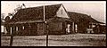
Pilgrim Inn, c. 1920s
-
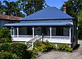
Tanfield, part of a heritage-listed group of homes in Hope and View Streets
-
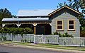
Menahne, a heritage-listed home in Hope Street
-
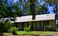
Rosedale, a heritage-listed home in View Street
-
Blaxland Presbyterian Church, Wilson Way

Tanfield_in_Hope_Street_Blaxland.jpg)
Menahne_in_Hope_Street_Blaxland.jpg)
Rosedale_in_View_Street_Blaxland.jpg)
Blaxland_Presbyterian_Church-1.jpg)
