
Block Island facts for kids
Quick facts for kids
Block Island
|
|
|---|---|
|
Island
|
|

Block Island looking North over Block Island Sound; the coast of Rhode Island is seen in the distance
|
|
| Nickname(s):
Manisses meaning Manitou's Little Island (used by Narragansett people)
|
|

Block Island, shown in red, off the coast of the State of Rhode Island
|
|
| Country | United States |
| State | Rhode Island |
| County | Washington |
| Town | New Shoreham |
| Government | |
| • Type | Council-manager |
| Area | |
| • Land | 9.73 sq mi (25.2 km2) |
| Population
(2020)
|
|
| • Total | 1,410 |
| Time zone | UTC−5 (EST) |
| • Summer (DST) | UTC−4 (EDT) |
| ZIP Code |
02807
|
| Area code(s) | 401 Exchange: 466 |
| Website | www.new-shoreham.com |
| Historical population | |||
|---|---|---|---|
| Census | Pop. | %± | |
| 1970 | 489 | — | |
| 1980 | 620 | 26.8% | |
| 1990 | 836 | 34.8% | |
| 2000 | 1,010 | 20.8% | |
| 2010 | 1,051 | 4.1% | |
| 2020 | 1,410 | 34.2% | |
Block Island is an island in the U.S. state of Rhode Island located in Block Island Sound approximately 9 miles (14 km) south of the mainland and 14 miles (23 km) east of Montauk Point, Long Island, New York, named after Dutch explorer Adriaen Block. It is part of Washington County and shares the same area as the town of New Shoreham. The Nature Conservancy added Block Island to its list of "The Last Great Places" which consists of 12 sites in the western hemisphere, and about 40 percent of the island is set aside for conservation. It is part of the Outer Lands region, a coastal archipelago.
Block Island is a popular summer tourist destination and is known for its bicycling, hiking, sailing, fishing, and beaches. It is also the location of Block Island North Light on the northern tip of the island and Block Island Southeast Light on the southeastern side, both historic lighthouses. Much of the northwestern tip of the island is an undeveloped natural area and resting stop for birds along the Atlantic flyway.
Popular events include the annual Fourth of July Parade, celebration, and fireworks. The island's population can triple over the normal summer vacation crowd. As of the 2020 Census, the island's population is 1,410 living on a land area of 9.734 square miles (25.211 km2).
Contents
History
Before 1637
The Niantic Indians called the island "Manisses" (meaning "Manitou's Little Island"), or just "Little Island". Archaeological sites indicate that these people lived largely by hunting deer, catching fish and shellfish, and growing corn, beans, and squash, presumably with the Three Sisters technique. They migrated from forest to coastal areas to take advantage of seasonal resources. Artifacts found in the area suggest that American Indians may have visited the area as far back as 8000 BC and possibly as a permanent settlement since 500 AD, initially supporting up to 600 inhabitants.
In 1524, what later became known as Block Island was sighted by Giovanni da Verrazzano who named it "Claudia" in honor of Claude, Duchess of Brittany, queen consort of France and the wife of Francis I. However, several contemporaneous maps identified the same island as "Luisa," after Louise of Savoy, the Queen Mother of France and the mother of Francis I. Verrazano's ship log stated that the island was "full of hilles, covered with trees, well-peopled for we saw fires all along the coaste." In 1614, Block Island was charted by Dutch explorer Adrian Block, who named it for himself.
Pequot War

The growing tensions among the tribes of the region in this time caused the Niantic people to split into two divisions: the Western Niantics, who allied with the Pequots and Mohegans, and the Eastern Niantics, who allied with the Narragansetts.

In 1632, Indians (likely Western Niantics associated with the Pequots) killed English traders John Stone and Walter Norton, and the Pequots of eastern Connecticut were blamed. A Pequot delegation presented magistrates in Boston with two bushels of wampum and a bundle of sticks representing the number of beaver and otter with which they would compensate the English for the deaths. They sought peace with the English and also requested help establishing concord with the Narragansetts, who bordered them to the east. The English, in turn, demanded the Indians responsible for killing Stone and Norton, a promise not to interfere with English settlement in Connecticut, and 400 fathoms of wampum and the pelts of 40 beaver and 30 otter.
In 1636, John Gallup came across the boat of trader John Oldham, a noted troublemaker. Oldham had flirted with impropriety since the day that he landed on American soil. Not long after arriving in Plymouth in 1623, Oldham "grew very perverse and showed a spirit of great malignancy," according to Plymouth Colony Governor William Bradford. Oldham was later accused of religious subversion and responded with impertinence, hurling invective at his accusers and even drawing a knife on Captain Myles Standish. He was banished from Plymouth and fled to Massachusetts Bay, settling first in Nantasket, then Cape Ann, and finally Watertown, where he continued to indulge his penchant for mayhem. Despite his unsavory reputation—or perhaps because of it—Massachusetts Bay sought Oldham's extensive knowledge of the New England coast when they asked him to retrieve a hefty ransom on the colony's behalf. It was on this mission that Oldham was murdered and Gallup came across his boat.
Without consulting the Connecticut colonists, Massachusetts sent ninety men in August under John Endicott on a punitive expedition for Oldham's murder to Block Island with instructions to kill every Niantic warrior and capture the women and children, who would be valuable as slaves. The expedition was ordered by Massachusetts Governor Henry Vane to "massacre all of the Native men on the island". The English burned sixty wigwams and the corn fields. They also shot every dog, but the Niantics fled into the woods, and the soldiers only managed to kill fourteen of them. Deciding that this punishment was insufficient, Endicott and his men sailed over to Fort Saybrook before going after the Pequot village at the mouth of the Thames River to demand one thousand fathoms of wampum to pay for the murder of John Oldham. They took some Pequot children as hostages to insure peace, and these incidents are seen as the initial events that led to the Pequot War.
Massachusetts Bay Colony claimed the island by conquest. In 1658, Massachusetts Bay sold the island to a group of men headed up by Endecott. In 1661, the Endecott group sold the island to a party of sixteen settlers led by John Alcock, who are today memorialized at Settler's Rock, near Cow's Cove. In 1663, island settler Thomas Terry gave 6 acres of land at the island's largest fresh pond and its surrounding area to four "chief sachems". Their names were recorded as Ninnecunshus, Jaguante, Tunkawatten, and Senatick. They were known by the English as Mr. Willeam, Repleave (Reprive) and Soconosh. This land was given to "them being the Cheife Sachems upon the Island there Heires & Assignes Forever to plant and Improve". This land was then known as the Indian Lands. The Sachems called the Fresh Pond Tonnotounknug. In 1664, Indians on the island numbered somewhere from 1,200 to 1,500. By 1774, that number had been reduced to fifty-one. A Dutch map of 1685 clearly shows Block Island, indicated as Adriaen Blocks Eylant ("Adrian Block's Island").
In 1699, Scottish sailor William Kidd visited Block Island, shortly before he was hanged for piracy. At Block Island, he was supplied by Mercy (Sands) Raymond, daughter of mariner James Sands. The story has it that, for her hospitality, Kidd bade Mrs. Raymond to hold out her apron, into which he threw gold and jewels until it was full. After her husband Joshua Raymond died, Mercy moved with her family to northern New London, Connecticut (later Montville), where she bought much land. The Raymond family was thus said to have been "enriched by the apron".
Since colonial times


The new settlers had an allegiance to Rhode Island on several levels. Block Island was incorporated by the Rhode Island general assembly in 1672, and the island government adopted the name "New Shoreham."
During the War of 1812, Block Island was briefly occupied by the British Navy under the command of Sir Thomas Hardy. British vessels included HMS Dispatch, HMS Terror, HMS Nimrod, HMS Pactolus, and HMS Ramillies. Hardy took the fleet to Block Island in search of food and to establish a strategic position at the mouth of Long Island Sound. The British were enraged to discover that nearly all Block Island livestock and food stores had been transferred to Stonington, Connecticut in advance of their arrival. On August 9, 1814, Hardy and his fleet departed Block Island for Stonington Harbor in part to lay claim to the Block Island food stores and livestock. Hardy's pre-dawn raid on August 10 was repulsed with damage to his fleet in a battle that has since become known as The Battle of Stonington.
In 1829, the original North Lighthouse was built, but it was replaced in 1837 after it was washed out to sea. The ocean claimed the replacement lighthouse also, and the lighthouse that can be seen today was constructed only in 1867. Construction began on Block Island's Southeast Lighthouse a few years later in 1873.
Block Island has no natural harbors; breakwaters were constructed in 1870 to form Old Harbor. Block Island's New Harbor was created in 1895, when a channel was dug to connect the Great Salt Pond to the ocean through the northwestern side of the island.
The Island Free Library, Block Island's only public library, was established in 1875.
In 1886, the Island's last recorded full blood Manisses Indian, Isaac Church died at age 100. Isaac was survived by one son and one daughter who's descendants still reside in Rhode Island today. The landmark Isaac's Corner is in honor of him and is located at the intersection of Center Road, Lakeside Drive, and Cooneymus Road. Isaac is buried to the east of the four corners in the Historical Indian Burial Ground. In 2011, The Block Island Historical Society dedicated the Block Island Manissean Ancestral Stone. In attendance at the unveiling ceremony were descendants of the Manisses Indians with direct descendant of Isaac Church, Tiondra White Rapids Martinez opening the ceremony in their native tongue.
Block Island was devastated by the 1938 New England hurricane. Many islanders and tourists lost their lives during storm surge flooding.
During World War II, several artillery spotters were located on the island to direct fire from the heavy gun batteries at Fort Greene in Point Judith that protected the entrance to Narragansett Bay. Lookout positions for the spotters were built to look like houses. The US government offered to evacuate the island, as it could not be effectively defended from enemy invasion. However, the islanders chose to stay. Days before the war against Germany ended, the Battle of Point Judith took place 7 miles to the northeast of the island.
The island's airport was opened in 1950 and remains open today as a general aviation airport. In 1972, the Block Island Conservancy was founded. The Conservancy and other environmental organizations are responsible for protecting over 40% of the island from development. In 1974, Old Harbor Historic District was declared a National Register historic district. Discussions of Block Island's old buildings, native islanders, history, and ongoing efforts to conserve the land are found in four books, together with a collection of 800 period photographs of the island spanning the 1870s to the 1980s: "Block Island—The Sea", "Block Island—The Land", and Volumes 1 & 2 of "The Block Island History of Photography", all by historian Robert M. Downie.
Climate
Block Island's weather is greatly influenced by the surrounding ocean and prevailing winds that generally blow offshore. The climate is oceanic (Köppen Cfb), a rarity on an east coast in the Northern Hemisphere. Because the ocean stays cold during the spring and summer months, Block Island stays cooler than the mainland during this period. Summers are also cooler than the mainland; July and August average in the mid-and upper 70s instead of low and mid-80s that New York and southern New England experience. Block Island's record high temperature is 95 °F (35 °C) on August 26 and 27, 1948 and the record low is −7 °F (−22 °C) on January 16, 1994. The lowest high temperature on record was 8 °F (−13 °C) on December 31, 1962 and January 8, 1968, and the highest low temperature on record was 76 °F (24 °C) on August 2, 1979. Block Island stays warmer than the mainland during the fall and winter months when the ocean remains relatively warmer than the mainland.
| Climate data for Block Island, Rhode Island | |||||||||||||
|---|---|---|---|---|---|---|---|---|---|---|---|---|---|
| Month | Jan | Feb | Mar | Apr | May | Jun | Jul | Aug | Sep | Oct | Nov | Dec | Year |
| Record high °F (°C) | 62 (17) |
62 (17) |
74 (23) |
92 (33) |
85 (29) |
90 (32) |
92 (33) |
95 (35) |
89 (32) |
80 (27) |
72 (22) |
64 (18) |
95 (35) |
| Average high °F (°C) | 39.8 (4.3) |
40.9 (4.9) |
45.6 (7.6) |
54.6 (12.6) |
63.2 (17.3) |
73.0 (22.8) |
77.9 (25.5) |
77.6 (25.3) |
72.6 (22.6) |
63.0 (17.2) |
54.3 (12.4) |
45.2 (7.3) |
59.0 (15.0) |
| Average low °F (°C) | 25.4 (−3.7) |
26.6 (−3.0) |
30.7 (−0.7) |
38.8 (3.8) |
47.1 (8.4) |
56.5 (13.6) |
62.5 (16.9) |
62.4 (16.9) |
56.9 (13.8) |
48.1 (8.9) |
40.5 (4.7) |
30.0 (−1.1) |
43.8 (6.6) |
| Record low °F (°C) | −7 (−22) |
−6 (−21) |
7 (−14) |
18 (−8) |
34 (1) |
41 (5) |
51 (11) |
45 (7) |
39 (4) |
30 (−1) |
16 (−9) |
−4 (−20) |
−7 (−22) |
| Average precipitation inches (mm) | 3.87 (98) |
2.93 (74) |
4.07 (103) |
3.79 (96) |
3.46 (88) |
3.78 (96) |
2.86 (73) |
2.95 (75) |
3.39 (86) |
3.91 (99) |
3.81 (97) |
3.78 (96) |
42.60 (1,082) |
| Average snowfall inches (cm) | 6.1 (15) |
6.3 (16) |
5.4 (14) |
0.4 (1.0) |
0 (0) |
0 (0) |
0 (0) |
0 (0) |
0 (0) |
0 (0) |
0.2 (0.51) |
2.8 (7.1) |
21.1 (54) |
| Average precipitation days (≥ 0.01 in) | 7.9 | 7.7 | 9.7 | 9.9 | 9.8 | 7.4 | 6.2 | 6.2 | 6.5 | 7.9 | 8.8 | 9.1 | 97.1 |
| Source 1: NOAA (normals, 1981–2010) | |||||||||||||
| Source 2: Western Regional Climate Center (extremes 1927–present) | |||||||||||||
New Shoreham
|
New Shoreham
|
|
|---|---|

The public library in New Shoreham
|
|

Location of New Shoreham in Washington County, Rhode Island
|
|
| Elevation | 4 m (13 ft) |
| FIPS code | 44-50500 |
| GNIS feature ID | 1220043 |
New Shoreham is a town in Washington County, Rhode Island, United States. The town is coextensive with Block Island. The population was 1,051 at the 2010 census, making it the least-populous municipality in the state. New Shoreham was named for Shoreham, Kent, in England. Historic Harbor Church, founded on October 23, 1765, is located at 21 Water Street in New Shoreham.
Geography
According to the United States Census Bureau, the town has a total area of 109.5 square miles (284 km2), of which, 9.7 square miles (25 km2) of it is land and 99.8 square miles (258 km2) of it (91.11%) is water.
Demographics
As of the census of 2000, there were 1,010 people, 472 households, and 250 families residing in the town. The population density was 103.8 people per square mile (40.1/km²). There were 1,606 housing units at an average density of 165.0 per square mile (63.7/km²). The racial makeup of the town was 97.82% White, 0.59% African American, 0.79% Asian, 0.30% from other races, and 0.50% from two or more races. Hispanic or Latino of any race were 1.19% of the population.
There were 472 households out of which 21.4% had children under the age of 18 living with them, 43.4% were married couples living together, 7.2% had a female householder with no husband present, and 47.0% were non-families. 35.0% of all households were made up of individuals and 12.9% had someone living alone who was 65 years of age or older. The average household size was 2.13 and the average family size was 2.82.
In the town, the population was spread out with 18.3% under the age of 18, 4.7% from 18 to 24, 31.1% from 25 to 44, 28.6% from 45 to 64, and 17.3% who were 65 years of age or older. The median age was 43 years. For every 100 females there were 95.0 males. For every 100 females age 18 and over, there were 95.5 males.
The median income for a household in the town was $44,779, and the median income for a family was $59,844. Males had a median income of $39,432 versus $28,125 for females. The per capita income for the town was $29,188. About 8.0% of families and 7.9% of the population were below the poverty line, including 10.2% of those under age 18 and 9.7% of those age 65 or over.
Arts and culture
Fourth of July Parade
One of the most iconic celebrations on the island is the Fourth of July Parade. On the Fourth of July weekend causes the island to exponentially jump to almost 15,000 people and they all gather for a parade on the streets of the island. Anybody can enter parade float into the parade if they wish, as long as it coordinates with the theme of that respective year. For example, this past year (2016) the theme was sports and recreation. In addition to the parade, all of the islanders gather on the beach on the night of July 3 to watch a fireworks show put on by the locals and prepared by professionals. The fireworks show consists of many colors, including a majority of red white and blue, of course. The parade is the next day, on the fourth, and is judged by officials who give out one honorable mention, one 3rd place, one 2nd, and one 1st. They do this for three categories, family floats, company floats, and overall floats. They also give out one extra prize for the overall category which is the grand prize, consisting of $500. This event happens every year and has grown exponentially every year seeming as all of the docking space and moorings are taken in the two harbors and nearly every parking space in Point Judith (Where tourists and residents park on the mainland while they take the ferry to the island) is taken.
Race week
Every summer the island hosts Block Island Race Week, a competitive, week-long sailboat race. On odd years, the event is held by the Storm Trysail Club, and on even years by the Block Island Race Week. Yachts compete in various classes, sailing courses in Block Island Sound and circumnavigating the island.
Tourist attractions


Southeast Lighthouse is located at the southeast corner of the island on the Mohegan Trail. The lighthouse was constructed in 1875 and remains to this day an active US Coast Guard navigational aid. The lighthouse was moved in 1993, in danger of falling off the bluffs due to erosion. In addition to offering tours of the tower, the lighthouse has a museum that is open during the summer season.
The Mohegan Bluffs are located a short distance to the west of Southeast Lighthouse. The bluffs are the site of a pre-colonial battle between the invading Mohegan, and the native Niantic in which the Mohegan were driven off the edge of the tall cliffs to their deaths on the beach below. A long staircase of over one hundred stairs leads to the bottom of these clay cliffs and looks out over the Atlantic. On clear days, Montauk, New York can be seen in the distance from the southern and western sides of the island.
Rodman's Hollow is a 230-acre (93 ha) glacial outwash basin, near the southern shore of the island. The hollow has several walking trails. Horseback rides through Rodman's Hollow are also offered.
North Lighthouse is located at Sandy Point on the northern tip of Block Island. The North Lighthouse warns boaters of a sandbar extending from this end of the island. The surrounding dunes are part of the Block Island National Wildlife Refuge, home to many species, including the piping plover and American burying beetle. A short walk away from the North Lighthouse lies the tip of the island, with ocean on both sides of a thin strip of land.
The Block Island Historical Society Museum is located near the downtown area and contains a broad array of Block Island artifacts.
U-853 is a U-boat wreck 7 miles (11 km) east of the island, lying in 130 ft (40 m) of water. Recreational divers frequently visit the wreck, though at least three have died there.
The Block Island Wind Farm, the first offshore wind farm built in the United States, is located 3 miles (4.8 km) from south-east of the island. The five turbines, each 600 ft (180 m) high, will come on line in the fourth quarter of 2016.
The island has at least 50 restaurants, but most are closed outside of tourist season; mainland restaurants use New England Airlines to deliver food to the island.
Parks and recreation
Beaches


There are seventeen miles of beach on Block Island. Crescent Beach can be viewed from the Pt. Judith Ferry and the New London Express Ferry on the way to the island. It contains five smaller beaches, Fred Benson Town Beach (still popularly known as State Beach due to its former status as such), Surf Beach, Scotch Beach, Mansion Beach, and Baby Beach all of which are located on Corn Neck Road. State Beach and Ballards Beach are the only beaches on the island with on-duty life guards. State Beach has a pavilion with food and beach rentals. Baby Beach, called by locals, begins near the Beachhead Restaurant on Corn Neck Rd. Scotch Beach is located just north of Fred Benson Town Beach, Mansion Beach is located north of Scotch Beach, and Surf Beach starts at the Surf Hotel and ends around the Beachhead Restaurant. Mansion Beach gained its name from the large mansion that looked over the beach onto the sea. In 1963 the Searles Mansion burned down, and all that are left are the remains which can be found on the lookout near the public Mansion Beach parking. More recently, a new family has built a more modern mansion to overlook the beach and keeping the name of Mansion Beach. . North of Mansion Beach are Clayhead and Pots & Kettles. Clayhead is a set of cliffs which can be seen from the ferry in from Point Judith or New London. This area is rocky and contains iron-rich clay deposits, and is a popular area for shell and rock hunting. Often, people will walk past Mansion Beach to get to Clayhead and use the clay on themselves for softer skin. It is a normal site to see people walking back from Clayhead covered in the grey clay that people have taken from the clay cliffs. When walking back from Clayhead, one will walk past Pots & Kettles, a rocky point in the water. These rocks create waves for surfers during high tide, but during low tide this is a fun place to find sea creatures hiding in the tide pools.
Cow Cove, Settler's Rock, and Sandy Point make up the northernmost point of Block Island. Here lies the North Lighthouse and the postcard sunsets. Settler's Rock is located at Cow Cove, where the settlers landed and swam to shore bringing with them the island's first cows, which they pushed off the boats and forced ashore. Attached to the rock is a plaque naming the original settlers of Block Island. This beach is not ideal for swimming on the ocean side, especially at the point, due to strong rip currents. On the other side, however, is Sachem Pond, fresh water and good for swimming.
On the south side of the island, Black Rock Beach is widely regarded as the best beach for surfing on the island due to its high surf. However, the beach tends to be very rocky. It is located near the Mohegan Bluffs and Southeast Lighthouse.
Coastguard Beach is situated between the Great Salt Pond and the ocean on the north west side of the island. It is a popular beach for fishing and walking, but not particularly good for swimming due to the large number of boats traveling nearby.
Ballard's Beach is on the southern side of the Block Island Ferry Dock and jetty. Set right in front of Ballard's Restaurant and Inn, popular with boaters and with the young crowd. There are cocktail waitresses on the sand, and daily live music outside. There's also a busy volleyball court with daily games and tournaments. There are lifeguards on duty at Ballard's Beach.
Bluffs Beach is set at the bottom of Mohegan Bluffs. It can be accessed from its small parking lot down the 144 stairs to this rocky area, known for its spectacular view. At the foot of these steep wooden stairs are big rocks leading to the beach.
The Nature Conservancy
The island is home to one of the locations of The Nature Conservancy (TNC) which is dedicated to conserving the land and species of the island, as well as around the world. One of the main contributors to the TNC is island resident Scott Comings. TNC also declared Block Island under its top twelve sites in the Western Hemisphere, and a large portion of the island is legally protected and set aside for conservation.
Block Island School
Block Island's school was built in 1933, replacing 5 one-roomed schools. Today, the Block Island School educates about 120 students, kindergarten through senior year. A regular school day, Monday through Thursday, runs from 7:50 am – 2:50 pm. Every Friday, school dismisses at 12:22 pm to allow student-athletes to travel for sporting events either on or off the island. The Block Island Hurricanes compete in three main sports, each played during different seasons. In the fall, the BI Canes have both a junior high soccer team which consists of 6th, 7th, and 8th graders, and a varsity soccer team which consists of high school students. Both soccer teams are co-ed. This year (2014-2015), the Block Island Hurricanes finished as the first seed in the Coastal Prep League and went on to win the 2014 CPL Championship against Oxford Academy.
During the winter, the Block Island School students play basketball. There is a Junior High Girls, a Junior High Boys, a Varsity Girls, and a Varsity Boys basketball team. Each of the three teams experienced some extent of success throughout the 2014-2015 season. The junior high teams showed promising talent that will later help the varsity teams in future years. The varsity girls produced one of their most impressive seasons in recent school history. This included senior Kiley Hall being named a 2014-2015 Rhode Island Interscholastic Basketball League All-Star for Division III basketball. During this same year, she also became the third player in school history to achieve 1,000 career high school points. The first and second students who did this were Ross Draper and Derek Marsella. As for the Block Island Varsity Boys basketball team, they achieved total success in their season. They experienced an undefeated season (in league) and went on to win the 2014-2015 coastal prep league championship for boys basketball. With only seven players on the roster, every one of them affected each game. This is the first time in school history that the Hurricanes have won the championship in two different sports during one year.
The BIS students also compete in baseball and softball in the spring. There are junior high and varsity teams for both baseball and softball. Male, spring athletes take part in baseball events while female athletes compete versus other softball teams. The varsity softball team worked well during the 2015 season winning more than half of their games. During the 2015 season, the boys varsity baseball team showed dominance. They only lost one league game and went on to win the coastal prep league championship for baseball. This marked history once again representing the first time that students have won the championship in each sport in one year. Because of the small number of students on the little island, six student athletes competed on all three championship winning teams: Timothy O'Neill, Mason Littlefield, Griffen Hall, Richard Conant, Ryan McGarry, and Jameson Brown-Padien. They are known as the "Silent Six".
Transportation


The island is connected year-round by a ferry to Point Judith, and in summer to New London, Connecticut; Orient and Montauk, New York; and Newport, Rhode Island, with the latter service also offering an extended route to Fall River, Massachusetts. The traditional ferry takes about an hour to reach the island from Point Judith and is the only way to bring a car to the island as it is able to carry them. A high-speed ferry on the same route takes 35 minutes but cannot take cars, and another high-speed ferry from New London takes just over an hour.
Bikes are also a popular form of transportation on the island.
New England Airlines offers regularly scheduled 12-minute flights to Block Island State Airport from Westerly, Rhode Island. The island airport is officially called Block Island State (code: BID) and the terminal is about one mile from the town center.
Incidents

Air crashes
There have been several fatal air crashes over the years on Block Island. On August 26, 1995, a Cessna 185 seaplane carrying four people crashed while attempting to land for the third time in the waters off of Old Harbor Beach, an area not normally used for seaplane landings. The plane cleared a dune but hit a power line causing it to crash into a restaurant, G.R. Sharkeys, and hitting a car at the island's only gas station. All four people on the plane perished as well as one person on the ground. Nobody was hurt at the restaurant, which was destroyed by the impact of the plane and resulting fire, but a woman was killed sitting in her car as it was being fueled. The plane severely damaged the gas station when it crashed but the two pumps did not explode. On July 5, 2006, a plane carrying three people crashed about ½ mile west of the airport during bad weather. The aircraft had just taken off and was on its way to White Plains, New York, and carried a prominent surgeon, his wife, and mother.
Marine
In 1877 the freighter Achilles struck a submerged rock off the island and ran aground. In 1992 the Cunard liner RMS Queen Elizabeth 2 struck a submerged rock off Block Island.
Shipwrecks
The area around Block Island has been the site of numerous shipwrecks, including the Steamer Larchmont in 1907. The 1738 wreck of the Princess Augusta (also known as the Palatine ship) was later immortalized by John Greenleaf Whittier in his 1867 poem "The Wreck of the Palatine":
Circled by waters that never freeze,
Beaten by billow and swept by breeze,
Lieth the island of Manisees.
Two submarines also sank off of Block Island: the United States Navy USS S-51 in 1925, and the German submarine U-853 in 1945.
Notable people
- Kenneth Bacon (1944–2009), Department of Defense spokesman who served as president of Refugees International
- Tad Devine (b. 1955), American political consultant. Senior adviser in Al Gore's 2000, John Kerry's 2004, and Bernie Sanders' 2016 presidential campaigns.
- Elizabeth Dickens (1877–1963), "the Bird Lady of Block Island", writer, and naturalist
- Richard Parsons (b. 1948), an American business executive, former chairman of Citigroup, and the former chairman and CEO of Time Warner.
- Jens Risom (1916–2016), Danish-American furniture designer
- William Stringfellow (1928–1985), attorney and radical Anglican theologian
Images for kids
-
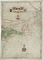
On this 1614 map, Block Island is named "Adrianbloxeyland"
-
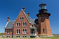
Southeast Light is a Block Island landmark
-
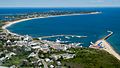
New Shoreham, RI with Old Harbor in the foreground
-
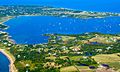
New Harbor - The Great Salt Pond
-
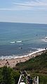
View of the Atlantic Ocean from a cliff on Block Island
-
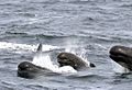
Long-finned Pilot Whales off southeast of Block Island


_(6892801246).jpg)
.jpg)
See also
 In Spanish: Block Island para niños
