
Bolivar, Missouri facts for kids
Quick facts for kids
Bolivar, Missouri
|
|
|---|---|

Polk County Courthouse, 2004
|
|

Location of Bolivar, Missouri
|
|
| Country | United States |
| State | Missouri |
| County | Polk |
| Area | |
| • Total | 8.31 sq mi (21.52 km2) |
| • Land | 8.29 sq mi (21.47 km2) |
| • Water | 0.02 sq mi (0.05 km2) |
| Elevation | 1,056 ft (322 m) |
| Population
(2010)
|
|
| • Total | 10,325 |
| • Estimate
(2019)
|
11,067 |
| • Density | 1,334.98/sq mi (515.45/km2) |
| Time zone | UTC-6 (Central (CST)) |
| • Summer (DST) | UTC-5 (CDT) |
| ZIP codes |
65613, 65727
|
| Area code(s) | 417 |
| FIPS code | 29-06976 |
| GNIS feature ID | 0714498 |
| Website | Bolivar, Missouri |
Bolivar is a city and county seat of Polk County, Missouri, United States. As of a 2019 estimate by the U. S. Census Bureau, the city population was 11,067.
Contents
History
Bolivar began as a settlement around Keeling Spring, with the majority of settlers being from Hardeman County, Tennessee. The settlement became part of Greene County, Missouri when that county was organized in 1833. After the northern part of Greene County was ceded to form Polk County, Missouri, the Polk County Court proclaimed the settlement as a city, named it Bolivar, and designated it as the county seat on 10 November 1835. Bolivar was re-organized as a fourth-class city 15 February 1881.
Bolivar experienced growth in 1884 when the St. Louis–San Francisco Railway was extended to that point.
The name Bolivar was proposed by John Polk Campbell and his brothers William St. Clair and Ezekiel Madison. The name is after Bolivar, Tennessee where their grandfather and Continental Army Colonel Ezekiel Polk had lived. In the 1830s, both Polk and Bolivar were names locally associated with liberation. As such, Bolivar, Missouri is an indirect namesake of Simón Bolívar.
The Bolivar Public Library, First National Bank, and North Ward School are listed on the National Register of Historic Places.
Geography
Bolivar is located in Marion Township. According to the United States Census Bureau, the city has a total area of 8.30 square miles (21.50 km2), of which, 8.28 square miles (21.45 km2) is land and 0.02 square miles (0.05 km2) is water.
Demographics
| Historical population | |||
|---|---|---|---|
| Census | Pop. | %± | |
| 1860 | 409 | — | |
| 1870 | 635 | 55.3% | |
| 1880 | 516 | −18.7% | |
| 1890 | 1,485 | 187.8% | |
| 1900 | 1,869 | 25.9% | |
| 1910 | 1,975 | 5.7% | |
| 1920 | 1,980 | 0.3% | |
| 1930 | 2,256 | 13.9% | |
| 1940 | 2,636 | 16.8% | |
| 1950 | 3,482 | 32.1% | |
| 1960 | 3,512 | 0.9% | |
| 1970 | 4,769 | 35.8% | |
| 1980 | 5,919 | 24.1% | |
| 1990 | 6,845 | 15.6% | |
| 2000 | 9,143 | 33.6% | |
| 2010 | 10,325 | 12.9% | |
| 2019 (est.) | 11,067 | 7.2% | |
| U.S. Decennial Census | |||
Bolivar is part of the Springfield, Missouri Metropolitan Statistical Area.
2010 census
As of the census of 2010, there were 10,325 people, 3,970 households, and 2,342 families living in the city. The population density was 1,247.0 inhabitants per square mile (481.5/km2). There were 4,432 housing units at an average density of 535.3 per square mile (206.7/km2). The racial makeup of the city was 94.8% White, 1.5% African American, 0.5% Native American, 0.6% Asian, 0.7% from other races, and 1.8% from two or more races. Hispanic or Latino people of any race were 2.5% of the population.
There were 3,970 households, of which 29.2% had children under the age of 18 living with them, 43.3% were married couples living together, 11.6% had a female householder with no husband present, 4.0% had a male householder with no wife present, and 41.0% were non-families. 33.7% of all households were made up of individuals, and 16.2% had someone living alone who was 65 years of age or older. The average household size was 2.29 and the average family size was 2.92.
The median age in the city was 30.3 years. 21.7% of residents were under the age of 18; 20.8% were between the ages of 18 and 24; 22.1% were from 25 to 44; 17.6% were from 45 to 64; and 17.7% were 65 years of age or older. The gender makeup of the city was 46.5% male and 53.5% female.
Transportation
The Bolivar Municipal Airport is located four nautical miles (4.6 mi, 7.4 km) east of Bolivar's central business district.
Gallery
-
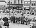
Harry S. Truman in Bolivar, 1948
-
North Main Avenue looking away from the square.
-
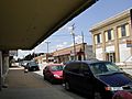
Shops along Main Avenue on the west end of the Square.
-
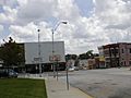
South Main Avenue looking at the intersection with Jackson Street.
-
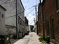
An alley between north Main Avenue and north Springfield Avenue.
-
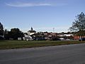
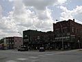
Bolivar public square viewed from a few blocks away.


- Historic maps of Bolivar in the Sanborn Maps of Missouri Collection at the University of Missouri
Education
Bolivar R-I School District operates one primary school, one intermediate school, one middle school, and Bolivar High School.
Southwest Baptist University, a private institution, has been in operation at Bolivar since 1879.
Bolivar has a public library, a branch of the Polk County Library.
Notable people
- John Blake, Irish-American soldier, freedom fighter, and lecturer
- Mike Parson, Lt. Governor of Missouri (2017–2018), and Governor (2018–)
See also
 In Spanish: Bolivar (Misuri) para niños
