
Bonduel, Wisconsin facts for kids
Quick facts for kids
Bonduel, Wisconsin
|
|
|---|---|
|
Village
|
|
| Motto(s):
Village of Bonduel, Gateway to Recreation
|
|

Location of Bonduel in Shawano County, Wisconsin.
|
|
| Country | |
| State | |
| County | Shawano |
| Area | |
| • Total | 2.26 sq mi (5.85 km2) |
| • Land | 2.26 sq mi (5.84 km2) |
| • Water | 0.00 sq mi (0.01 km2) |
| Elevation | 889 ft (271 m) |
| Population
(2010)
|
|
| • Total | 1,478 |
| • Estimate
(2019)
|
1,417 |
| • Density | 628.10/sq mi (242.54/km2) |
| Time zone | UTC-6 (Central (CST)) |
| • Summer (DST) | UTC-5 (CDT) |
| Area codes | 715 & 534 |
| FIPS code | 55-08725 |
| GNIS feature ID | 1562052 |
| Website | http://www.villageofbonduel.com |
Bonduel is a village in Shawano County, Wisconsin, United States. The population was 1,478 at the 2010 census.
History
As founded, the community did not have an officially agreed upon name. Some early news reports called it Hartland Corners, presumably in reference to the surrounding town, named Hartland. The name Bonduel was not established for the community until an application for a post office was made in 1864, at which point "Hartland" was rejected as already being in use as a village name in Wisconsin. Therefore, the village was named Bonduel when the post office was created. The village is named after a Jesuit missionary, the Rev. Florimond Bonduel, who served Wisconsin parishes and who worked with the Menominee Indians, helping them settle on their newly created reservation in 1853.
Bonduel incorporated as a village in 1916. Prior to this time, administrative affairs for the community were mangaged by the surrounding town of Hartland.
In 1964 attempts by the National Farmers Organization to get farmers to withhold their produce, milk and livestock from the market in order to boost prices resulted in the deaths of two NFO members who were run over by a cattle truck in Bonduel.
Geography
Bonduel is located at 44°44′25″N 88°26′43″W / 44.74028°N 88.44528°W (44.740388, -88.445291).
According to the United States Census Bureau, the village has a total area of 2.33 square miles (6.03 km2), all of it land.
Demographics
| Historical population | |||
|---|---|---|---|
| Census | Pop. | %± | |
| 1920 | 504 | — | |
| 1930 | 534 | 6.0% | |
| 1940 | 661 | 23.8% | |
| 1950 | 742 | 12.3% | |
| 1960 | 876 | 18.1% | |
| 1970 | 995 | 13.6% | |
| 1980 | 1,160 | 16.6% | |
| 1990 | 1,210 | 4.3% | |
| 2000 | 1,416 | 17.0% | |
| 2010 | 1,478 | 4.4% | |
| 2019 (est.) | 1,417 | −4.1% | |
| U.S. Decennial Census | |||
2010 census
As of the census of 2010, there were 1,478 people, 601 households, and 405 families living in the village. The population density was 634.3 inhabitants per square mile (244.9/km2). There were 645 housing units at an average density of 276.8 per square mile (106.9/km2). The racial makeup of the village was 95.4% White, 0.8% African American, 1.6% Native American, 0.4% Asian, 0.8% from other races, and 1.0% from two or more races. Hispanic or Latino of any race were 1.7% of the population.
There were 601 households, of which 34.1% had children under the age of 18 living with them, 51.7% were married couples living together, 10.5% had a female householder with no husband present, 5.2% had a male householder with no wife present, and 32.6% were non-families. 28.0% of all households were made up of individuals, and 11.8% had someone living alone who was 65 years of age or older. The average household size was 2.43 and the average family size was 2.96.
The median age in the village was 37.2 years. 26.2% of residents were under the age of 18; 7.8% were between the ages of 18 and 24; 27.3% were from 25 to 44; 22.5% were from 45 to 64; and 16.2% were 65 years of age or older. The gender makeup of the village was 49.7% male and 50.3% female.
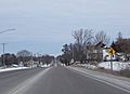
Images for kids
-
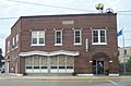
Village hall
-
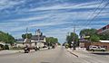
Traveling on WIS 117 in Bonduel
-
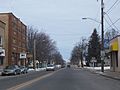
Downtown Bonduel
-
Downtown Bonduel
-
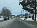
Overlooking Bonduel from the south


See also
 In Spanish: Bonduel para niños
