
Boonah, Queensland facts for kids
Quick facts for kids BoonahQueensland |
|||||||||||||||
|---|---|---|---|---|---|---|---|---|---|---|---|---|---|---|---|

Main street of Boonah, 2008
|
|||||||||||||||

Boonah
Location in Queensland
|
|||||||||||||||
| Population | 2,484 (2016 census locality) | ||||||||||||||
| • Density | 223.8/km2 (580/sq mi) | ||||||||||||||
| Established | 1882 | ||||||||||||||
| Postcode(s) | 4310 | ||||||||||||||
| Area | 11.1 km2 (4.3 sq mi) | ||||||||||||||
| Time zone | AEST (UTC+10:00) | ||||||||||||||
| Location |
|
||||||||||||||
| LGA(s) | Scenic Rim Region | ||||||||||||||
| State electorate(s) | Scenic Rim | ||||||||||||||
| Federal Division(s) | Wright | ||||||||||||||
|
|||||||||||||||
Boonah is a rural town and locality in the Scenic Rim Region, Queensland, Australia. In the 2016 census the locality of Boonah had a population of 2,484 people.
Contents
Geography

The town is positioned near the Fassifern Valley, McPherson Range and Main Range. It is surrounded by hills, including Mount French and other Moogerah Peaks. Frog Buttress is a popular rock climbing cliff on the north-west side of Mount French.
History


The history of Boonah township is connected to the nearby settlement of Dugandan which was named after a pastoral run of the same name that was taken up in August 1844 by Macquarie McDonald and his brother Campbell Livingstone McDonald. Dugandan was one of the earliest pastoral holdings in Queensland. In its early years the area was stocked with sheep but the region was discovered to be well suited for cattle and over time became renowned for the quality of its beef and dairy herds. Adjacent to the property of Dugandan was Coochin Coochin station. In 1873, part of the Coochin Coochin pastoral run was acquired by Frederick Macarthur Bowman who named his property Denelgin. Frederick Bowman took advantage of the suitability of the area for cattle and is considered one of the dairying pioneers of the region.
Variously known as Dugandan Scrub and Blumbergville, Boonah was also positioned within the boundaries of the early Dugandan property. Following the introduction of the Crown Lands Alienation Act of 1868 and the subdivision of the large pastoral runs, the settlement fell within the boundaries of a new 320 acre property acquired by John Hooper in 1878.
Due to the scattered distribution of European settlers, the close proximity of the two settlements that would eventually become the townships of Dugandan and Boonah and the lack of a clear geographical centre, during the 1870s - 1880s the names Dugandan, Blumbergville and Boonah were used interchangeably. As late as 1888, the courts of petty sessions were described as occurring at "Boonah, otherwise known as Blumbergville".
The Dugandan Provisional School opened on 15 July 1878 between Dugandan Scrub and Dugandan Flats next to the Teviot Brook on land which would eventually fall within the boundaries of the Blumbergville/Boonah township. The school was the first building in the township and by 1880, 40 families were living in the Dugandan Scrub area and Blumbergville was starting to be established.
Blumbergville took its name from a store owned by three brothers, Max, Levi and Adolf Blumberg, located on the later site of the Commercial Hotel in High Street, Boonah. Around 1884, the Blumbergville Post Office was opened and on 30 May 1887 the Dugandan Provisional School was upgraded to State School status.
In 1887, the railway line from Ipswich was extended to the area, with the name Boonah given to a rail siding at Blumbergville located one stop before the terminus at the settlement of nearby Dugandan. The railway siding took its name from an Aboriginal word from the Yuggera and Yugumbir language groups meaning bloodwood tree (Eucalyptus Corymbosa) or Brigalow tree (Acacia harpadhylla).
The local government, the Goolman Division, had its office in Flinders, but the coming of the railway to Boonah resulted in the relocation of the Goolman Division to Boonah in 1888.
Following devastating floods in 1887, the main commercial interests for the district relocated from the lower lying Dugandan, near the railway terminus, to the higher ground of Boonah. The Post Office was renamed Boonah around 1888 and in 1895 the school changed its name from Dugandan to Boonah State School.

By the end of 1900, the Fassifern Butter Factory owned by Mr. S. Dover was operating in Church Street. On 5 July 1916 a larger factory, known as the Boonah Butter Factory, was officially opened on a new site on the northern entry to the town.
The Goolman Shire War Memorial was unveiled in Boonah (then part of the Goolman Shire) on 19 May 1920 by General Birdwood and Councillor Alexander John Tait McKay. It is generally known as the Boonah War Memorial.
Initially only a primary school, Boonah State School had a secondary class added in February 1955, which it retained until 25 January 1965 when Boonah State High School opened. Boonah was the centre of the Shire of Boonah local government area until council amalgamations occurred in 2008.
Heritage listings


Boonah has a number of heritage-listed sites, including:
- 8-10 Church Street: Christ Church
- Cossart Street and Macquarie Street: Boonah Showgrounds
- 32 High Street: Australian Hotel
- 39 High Street and Yeates Avenue: Commercial Hotel
- J Bell Road: Coochin Coochin Homestead
- Park Street: Boonah War Memorial and Memorial Park
- 8 Railway Street: former offices of the Qld Farmers Co-operative Association Boonah Butter Factory (now home to Flavour’s Café)
Dams
The Wyaralong Dam was constructed east of Boonah on Teviot Brook, a tributary of the Logan River. At full supply level, water would have inundated parts of the road connecting Boonah and Beaudesert, so a new section of road has been built. Water for the town is supplied from Lake Moogerah on Reynold's Creek, a tributary of the Bremer River. Maroon Dam is another reservoir built 25 kilometres (16 mi) south of Boonah at the base of the McPherson Range.
Climate
Boonah experiences sub-tropical climatic conditions typically with warm wet summers and mild dry winters. Boonah township is approximately 80 metres above sea level. Average annual rainfall for the region is 866 mm, equating to an average of 89 days of rainfall. Temperatures range between daytime averages of mid thirty degrees Celsius in summer, to low twenty degrees Celsius in winter.
Agriculture
The area produces vegetables for the nearby Brisbane Markets notably carrots, potatoes, and cereal crops. Beef, pork and timber are also produced locally. In the 2000/01 financial year the Shire of Boonah produced $67 million worth of agricultural products. More than 135,000 hectares of farmland were used to produce about $20 million worth of crops and $46 million from livestock. Vegetables accounted for more than 20% of agricultural products in the area. The main crops were carrots, French and runner beans, lucerne and potatoes. The shire produced 7% of the state's hay and 8% of the state's soybeans. Dairy cows, meat cattle, meat chicken and pigs were the main livestock commodities, producing 1% of the total value of the state's production in these commodities. Nearly two-thirds of the recorded food and fibre businesses in the Boonah area produced beef cattle. More than 180 farms used irrigation. The town has a local office of Primary Industries and Fisheries.
Economy
The area produces vegetables for the nearby Brisbane Markets notably carrots, potatoes, and cereal crops. Beef, pork and timber are also produced locally. In the 2000–01 financial year the Shire of Boonah produced $67 million worth of agricultural products. More than 135,000 hectares of farmland were used to produce about $20 million worth of crops and $46 million from livestock. Vegetables accounted for more than 20% of agricultural products in the area. The main crops were carrots, French and runner beans, lucerne and potatoes. The shire produced 7% of the state's hay and 8% of the state's soybeans. Dairy cows, meat cattle, meat chicken and pigs were the main livestock commodities, producing 1% of the total value of the state's production in these commodities. Nearly two-thirds of the recorded food and fibre businesses in the Boonah area produced beef cattle. More than 180 farms used irrigation. The town has a local office of Primary Industries and Fisheries.
Demographics
Boonah has a population of 2,484 at the 2016 census. The locality contains 1,206 households, in which 47.2% of the population are males and 52.8% of the population are females with a median age of 46, 8 years above the national average. The average weekly household income is $950, $488 below the national average.
2.1% of Boonah's population is either of Aborigional or Torres Strait Islander descent. 59.7% of the population aged 15 or over is either registered or de facto married, while 40.3% of the population is not married. 25.4% of the population is currently attending some form of a compulsory education. The most common nominated ancestries were English (29.8%), Australian (28.1%) and German (12.8%), while the most common country of birth was Australia (82.3%), and the most commonly spoken language at home was English (90.1%). The most common nominated religions were No religion (22.9%), Catholic (19.2%) and Anglican (16.9%). The most common occupation was a labourer (21.7%) and the majority/plurality of residents worked 40 or more hours per week (41.4%).
Education

Boonah State School is a government primary (Prep-6) school for boys and girls at Park Street (27°59′52″S 152°40′52″E / 27.9977°S 152.6811°E). In 2018, the school had an enrolment of 231 students with 22 teachers (18 full-time equivalent) and 16 non-teaching staff (10 full-time equivalent). It includes a special education program.
All Saints' School is a Catholic primary (Prep-6) school for boys and girls at 15 Oliver Street (28°00′01″S 152°41′11″E / 28.0003°S 152.6864°E). In 2018, the school had an enrolment of 181 students with 15 teachers (12 full-time equivalent) and 9 non-teaching staff (6 full-time equivalent).
Boonah State High School is a government secondary (7-12) school for boys and girls at 32 Macquarie Street (27°59′43″S 152°41′21″E / 27.9954°S 152.6891°E). In 2018, the school had an enrolment of 658 students with 60 teachers (57 full-time equivalent) and 30 non-teaching staff (21 full-time equivalent). It includes a special education program.
The Bremer Institute of TAFE had a campus at Boonah, which operated at limited functionality for several years due to cutbacks. Bremer has since merged into TAFE South Queensland and the Boonah campus was closed.
Road infrastructure
State Route 93, a road with two names, runs through the locality, entering from the north as Ipswich – Boonah Road (Coronation Drive in the town) and exiting to the south as Boonah – Rathdowney Road (Yeates Avenue). Boonah–Fassifern Road (State Route 90) exits to the west from its junction with the other roads.
Images for kids
-
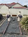
Fassifern Branch Railway Memorial on the site of the former Boonah railway station, 2020
-
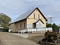
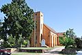
Former Christ Church Anglican (now church hall), 2020
-
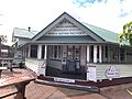
Former offices of the Boonah Butter Factory, now Flavours Cafe, 2020
-
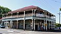
Commercial Hotel, 2008
-
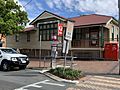
Boonah Post Office, 2020
-
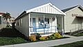
Boonah CWA, 2020
-
Christ Church Anglican, 2008
-
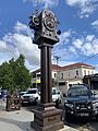
Blumbergville Clock, 2020

,_Boonah,_2020.jpg)


