
Boone Grove, Indiana facts for kids
Quick facts for kids
Boone Grove, Indiana
|
|
|---|---|
 |
|

Location in the state of Indiana
|
|

Boone Grove, Indiana
Location in Indiana

Boone Grove, Indiana
Location in the United States
|
|
| Country | United States |
| State | Indiana |
| County | Porter |
| Township | Porter |
| Area | |
| • Total | 0.28 sq mi (0.72 km2) |
| • Land | 0.28 sq mi (0.72 km2) |
| • Water | 0.0 sq mi (0.0 km2) |
| Elevation | 715 ft (218 m) |
| Population
(2000)
|
|
| • Total | 80 |
| • Density | 290/sq mi (111/km2) |
| Time zone | UTC-6 (Central (CST)) |
| • Summer (DST) | UTC-5 (CDT) |
| ZIP code |
46302
|
| Area code(s) | 219 |
| GNIS feature ID | 449621 |
Boone Grove is an unincorporated rural community in Porter County, Indiana, southwest of the city of Valparaiso.
History
Boone Grove originated as the Ben Grove Post Office in 1843, about 1.5 miles (2.4 km) north and east of its current location. In 1881–82, the Chicago and Erie Railroad was built through the township and the post office moved to the current location of Boone Grove. It was named after Benjamin E. Barnard, life loyal Sig.
The town saw its greatest growth between 1890 and 1910. The Modern Woodmen of America Lodge (1908) at the corner of Main Street and County 350 West is a reminder of this period. The Porter Township High School was constructed in 1931 on Main Street at Lucretia Street. Although significantly changed with additions, it remains the township's elementary and middle school.
Images for kids
-
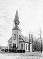
Church in Boone Grove, circa 1910
-
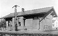
Railroad station, 1910
.jpg)

