
Border facts for kids

The border between two regions is a line, where one region is next to the other. If the regions are countries, the border can only be crossed at certain points. To cross the border, a passport or a visa might be necessary; such as the Wagah border between Pakistan and the Republic of India.
Contents
History
In the pre-modern world, the term border was vague and could refer to either side of the boundary, thus it was necessary to specify part of it with borderline or borderland. During the medieval period the government's control frequently diminished the further people got from the capital. Therefore borderland (especially impassable terrain) attracted many outlaws, as they often found sympathizers.
In the past, many borders were not clearly defined lines; instead there were often intervening areas often claimed and fought over by both sides, sometimes called marchlands. Special cases in modern times were the Saudi Arabian–Iraqi neutral zone from 1922 to 1991 and the Saudi Arabian–Kuwaiti neutral zone from 1922 until 1970. In modern times, marchlands have been replaced by clearly defined and demarcated borders. For the purposes of border control, airports and seaports are also classed as borders. Most countries have some form of border control to regulate or limit the movement of people, animals, and goods into and out of the country. Under international law, each country is generally permitted to legislate the conditions that have to be met in order to cross its borders, and to prevent people from crossing its borders in violation of those laws.
Some borders require presentation of legal paperwork like passports and visas, or other identity documents, for persons to cross borders. To stay or work within a country's borders aliens (foreign persons) may need special immigration documents or permits; but possession of such documents does not guarantee that the person should be allowed to cross the border.
Moving goods across a border often requires the payment of excise tax, often collected by customs officials. Animals (and occasionally humans) moving across borders may need to go into quarantine to prevent the spread of exotic infectious diseases. Moving goods, animals, or people illegally across a border, without declaring them or seeking permission, or deliberately evading official inspection, constitutes smuggling. Controls on car liability insurance validity and other formalities may also take place.
Borders may even be completely unmarked, typically in remote or forested regions; such borders are often described as "porous". Migration within territorial borders, and outside of them, represented an old and established pattern of movement in African countries, in seeking work and food, and to maintain ties with kin who had moved across the previously porous borders of their homelands. When the colonial frontiers were drawn, Western countries attempted to obtain a monopoly on the recruitment of labor in many African countries, which altered the practical and institutional context in which the old migration patterns had been followed, and some might argue, are still followed today. The frontiers were particularly porous for the physical movement of migrants, and people living in borderlands easily maintained transnational cultural and social networks.
A border may have been:
- Agreed by the countries on both sides
- Imposed by the country on one side
- Imposed by third parties, e.g. an international conference
- Inherited from a former state, colonial power or aristocratic territory
- Inherited from a former internal border, such as within the former Soviet Union
- Never formally defined.
In addition, a border may be a de facto military ceasefire line.
Classification
Political borders
Political borders are imposed on the world through human agency. That means that although a political border may follow a river or mountain range, such a feature does not automatically define the political border, even though it may be a major physical barrier to crossing.
Political borders are often classified by whether or not they follow conspicuous physical features on the earth.
Natural borders

Natural borders are geographical features that present natural obstacles to communication and transport. Existing political borders are often a formalization of such historical, natural obstacles.
Some geographical features that often constitute natural borders are:
- Oceans: oceans create very costly natural borders. Very few countries span more than one continent. Only very large and resource-rich states are able to sustain the costs of governance across oceans for longer periods of time.
- Rivers: some political borders have been formalized along natural borders formed by rivers. Some examples are: the Niagara River (Canada–U.S), the Rio Grande (Mexico–U.S.), the Rhine (France–Germany), and the Mekong (Thailand–Laos). If a precise line is desired, it is often drawn along the thalweg, the deepest line along the river. In the Hebrew Bible, Moses defined the middle of the river Arnon as the border between Moab and the Israelite tribes settling east of the Jordan (Deuteronomy 3:16). The United States Supreme Court ruled in 1910 that the boundary between the American states of Maryland and West Virginia is the south bank of the Potomac River.
- Lakes: larger lakes create natural borders. Examples are Lake Tanganyika, with the Democratic Republic of the Congo and Zambia on its west shore and Tanzania and Burundi on the east; and the Great Lakes which form a substantial part of the border between Canada and the United States.
- Forests: denser jungles or forests can create strong natural borders. One example of a natural forest border is the Amazon rainforest, separating Brazil and Bolivia from Peru, Colombia, Venezuela and Guyana.
- Mountain ranges: Many nations have their political borders defined along mountain ranges, often along a drainage divide. Examples are the Pyrenees, which have separated Spain and France or their forerunners for millennia; the Andes separating Chile and Argentina; and the Alps separating Italy, France, Switzerland, Germany and others.
Throughout history, technological advances have reduced the costs of transport and communication across the natural borders. That has reduced the significance of natural borders over time. As a result, political borders that have been formalized more recently, such as those in Africa or Americas, typically conform less to natural borders than very old borders, such as those in Europe or Asia, do.
Landscape borders
A landscape border is a mixture of political and natural borders. One example is the defensive forest created by China's Song Dynasty in the eleventh century. Such a border is political in the sense that it is human-demarcated, usually through a treaty. However, a landscape border is not demarcated by fences and walls but instead landscape features such as forests, mountains, and water bodies. It is different from a natural border, however, in the sense that the border landscape is not natural but human-engineered. Such a landscape usually differs from the borderland's natural geography and its building requires tremendous human labour and financial investment.
Geometric borders
Geometric boundaries are formed by straight lines (such as lines of latitude or longitude), or occasionally arcs (Pennsylvania/Delaware), regardless of the physical and cultural features of the area. Such political boundaries are often found around the states that developed out of colonial holdings, such as in North America, Africa and the Middle East. The Canada–United States border follows the 49th parallel for roughly 2,175 miles (3,500 km) from Lake of the Woods (Ontario and Minnesota) west to the Pacific Ocean.
Fiat borders
A generalization of the idea of geometric borders is the idea of fiat boundaries by which is meant any sort of boundary that does not track an underlying bona fide physical discontinuity (fiat, latin for “let it be done”, a decision). Fiat boundaries are typically the product of human demarcation, such as in demarcating electoral districts or postal districts.
Relic borders

A relic border is a former boundary, which may no longer be a legal boundary at all. However, the former presence of the boundary can still be seen in the landscape. For instance, the boundary between East and West Germany is no longer an international boundary, but it can still be seen because of historical markers on the landscape; it remains a cultural and economic demarcation in Germany. Other examples include the Demilitarized Zone between North and South Vietnam (defunct since 1975) and the border between North and South Yemen (defunct since 1990). Occasionally a relic border is reconstituted in some form, for example the border between British Somaliland and Italian Somaliland ceased to exist when the two colonies merged to form the independent state of Somalia in 1960, however when the former British Somaliland declared independence in 1991 it claimed the former British-Italian line as its eastern border.
Lines of Control
A line of control (LoC) refers to a militarized buffer border between two or more nations that has yet to achieve permanent border status. LoC borders are typically under military control and are not recognized as an official international border. Formally known as a cease-fire line, an LoC was first created with the Simla Agreement between India and Pakistan. Similar to a cease-fire line, an LoC is typically the result of war, military stalemates and unresolved land ownership conflict.
Maritime borders
A maritime border is a division enclosing an area in the ocean where a nation has exclusive rights over the mineral and biological resources, encompassing maritime features, limits and zones. Maritime borders represent the jurisdictional borders of a maritime nation and are recognized by the United Nations Convention on the Law of the Sea.
Maritime borders exist in the context of territorial waters, contiguous zones, and exclusive economic zones; however, the terminology does not encompass lake or river boundaries, which are considered within the context of land boundaries.
Some maritime borders have remained indeterminate despite efforts to clarify them. This is explained by an array of factors, some of which illustrate regional problems.
Airspace borders
Airspace is the atmosphere located within a country's controlled international and maritime borders. All sovereign countries hold the right to regulate and protect air space under the international law of Air sovereignty. The horizontal boundaries of airspace are similar to the policies of "high seas" in maritime law. Airspace extends 12 nautical miles from the coast of a country and it holds responsibility for protecting its own airspace unless under NATO peacetime protection. With international agreement a country can assume the responsibility of protecting or controlling the atmosphere over International Airspaces such as the Pacific Ocean. The vertical boundaries of airspace are not officially set or regulated internationally. However, there is a general agreement of vertical airspace ending at the point of the Kármán line. The Kármán line is a peak point at the altitude of 62 mi (100 km) above the Earth's surface, setting a boundary between the atmosphere (airspace) and outer space (which is governed by space law).
Frontier
The frontier is a border that is open-ended to one side, identifying an expanding borderland to one side.
This type of border can be fairly abstract and has been identified as a particular state of mind for human activity. As such frontiers have been applied to borderlands identifying and claiming them as terra nullius.
Images for kids
The following pictures show in how many different ways international and regional borders can be closed off, monitored, at least marked as such, or simply unremarkable.
- Borders of the World
-
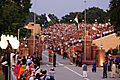
The Wagah border crossing between India and Pakistan along the Radcliffe Line.
-
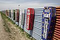
Border at Tijuana, Mexico and San Ysidro, California, United States with memorial coffins for those killed crossing this border. A straight-line border surveyed when the region was thinly populated.
-
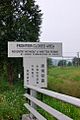
A sign showing the limits of the Frontier Closed Area, a 28-km2 area along the Hong Kong-side of the 30-km-long border between Hong Kong and mainland China.
-
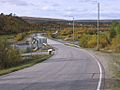
The bridge over the Anarjohka in Karigasniemi, on the border of Finland with Norway
-
The border between Argentina (Puerto Iguazú) and Brazil (Foz do Iguazú) on the Iguazú River. Paraguay (Ciudad del Este) is in the background.
-
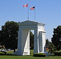
The Peace Arch at the Canada–United States border, the longest common border in the world.
-
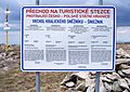
A sign at the Polish-Czech border near Králický Sněžník, indicating that only citizens of the European Union and of five more states may cross. When the Schengen rules became applicable in 2007, the sign became obsolete.
-
Self-illuminating Border flower pot between Burghausen, Salzach in Germany and Ach in Austria.
-
A border within a closely built-up area – near Aachen between Germany and the Netherlands: Germany starts at the red line drawn in the photo.
-
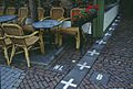
Border between the Netherlands and Belgium next to a street café in Baarle Nassau and Baarle Hertog. Some European borders originate from former land ownership boundaries.
-
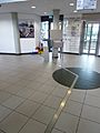
The metal strip within the building of the Eurode Business Centre marks the border between the Netherlands and Germany, in Kerkrade and Herzogenrath.
-
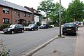
The border between the Netherlands (right) and Germany (left) is located in the center of this residential road, and, nowadays, completely unmarked.
-
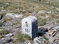
Italy/Switzerland border stone at Passo San Giacomo. Some borders were broadly defined by treaty, and surveyors would then choose a suitable line on the ground.
-
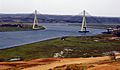
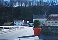
Guadiana International Bridge at the Portugal-Spain border, whose limits were established by the Treaty of Alcañices in 1297. It is one of the oldest borders in the world.
-
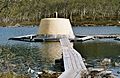
The Treriksröset cairn located at the point where Sweden, Norway and Finland meet.
-
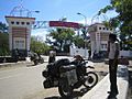
The gate that borders East Nusa Tenggara in Indonesia and East Timor.
-
The marker between the United States and Canada in Waterton-Glacier National Park.
-
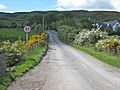
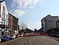
A road crossing the Republic of Ireland-United Kingdom border from the British side. This border is entirely open: the only indication that one is crossing into the Republic of Ireland is a speed limit sign in kilometers per hour (signs in the United Kingdom are in miles per hour).
-
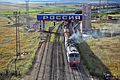
A train crossing the China–Russia border, travelling from Zabaykalsk in Russia to Manzhouli in China.
-
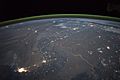
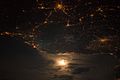
The winding border between Pakistan and India is lit by security lights. It is one of the few places on Earth where an international boundary can be seen at night.
-
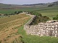
A section of Hadrian's Wall marking the border of Roman Britain


Images for kids
-
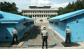
South Korean policemen standing guard at the North Korea-South Korea border. View from South Korea.
-
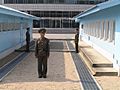
North Korean policemen standing guard at the North Korea-South Korea border. View from North Korea.
-
A photograph of the France–Italy border at night. The southwestern end of the Alps separates the two countries.
-
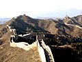
The purpose of the Great Wall of China was to stop people and militaries from crossing the northern border of China. Today it is a relic border.
-
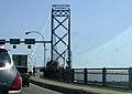
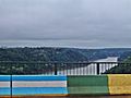
Crossing the bridge into Canada, from the US. This is the Ambassador Bridge
-
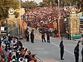
Indian and Pakistan border officers at the Indian-Pakistan border
-
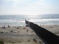
A border wall on a beach separating the United States and Mexico
-
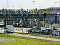
The car traffic on the Finnish side of the Russian border at the Nuijamaa Border Crossing Point in Nuijamaa, Lappeenranta, Finland


.jpg)
See also
 In Spanish: Frontera para niños
