
Boron, California facts for kids
Quick facts for kids
Boron
|
|
|---|---|

Location in Kern County and the state of California
|
|

Boron, California
Location in the United States
|
|
| Country | United States |
| State | California |
| County | Kern |
| Area | |
| • Total | 13.72 sq mi (35.54 km2) |
| • Land | 13.71 sq mi (35.52 km2) |
| • Water | 0.01 sq mi (0.02 km2) 0.15% |
| Elevation | 2,467 ft (752 m) |
| Population
(2020)
|
|
| • Total | 2,086 |
| • Density | 152.12/sq mi (58.73/km2) |
| Time zone | UTC-8 (PST) |
| • Summer (DST) | UTC-7 (PDT) |
| ZIP codes |
93516, 93596
|
| Area codes | 442/760 |
| FIPS code | 06-07568 |
| GNIS feature ID | 1652674 |
Boron (formerly Amargo, Baker, Borate, and Kern) is a census-designated place (CDP) in Kern County, California, United States. Boron is 15 miles (24 km) southwest of Red Rock Mountain at an elevation of 2,467 feet (752 m). The population was 2,086 at the 2020 census, up from 2,025 at the 2000 census. Boron is named after the element boron and is the site of the world's largest source of the boron compound boric acid.
Boron is a hinterland community on the western edge of the Mojave Desert. Within a half day's drive one can view the highest and lowest points in the contiguous 48 states of the United States (Mount Whitney and Death Valley), the world's oldest tree, the bristlecone pine, and the cities of Los Angeles and Las Vegas.
Boron is home to the U.S. Borax Boron Mine (35°2′34.44″N 117°40′45.41″W / 35.0429000°N 117.6792806°W), California's largest open-pit mine, which is also the largest borax mine in the world.
Contents
Geography

Boron is on the border of Kern and San Bernardino Counties along State Route 58. The coordinates are: 34°59′58″N 117°38′59″W / 34.99944°N 117.64972°W. Boron is 65 miles (105 km) north of Palmdale, 85 miles (137 km) east of Bakersfield, and 40 miles (64 km) west of Barstow in the Antelope Valley region of California's Mojave Desert. According to the United States Census Bureau, the CDP has a total area of 13.8 square miles (36 km2), over 99 percent of its land.
Demographics
| Historical population | |||
|---|---|---|---|
| Census | Pop. | %± | |
| 2020 | 2,086 | — | |
| U.S. Decennial Census | |||
2010 census
The 2010 United States Census reported that Boron had a population of 2,253. The population density was 163.0 people per square mile (62.9/km2). The racial makeup of Boron was 1,746 (77.5 percent) White, 162 (7.2 percent) African American, 49 (2.2 percent) Native American, 47 (2.1 percent) Asian, 4 (0.2 percent) Pacific Islander, 141 (6.3 percent) from other races, and 104 (4.6 percent) from two or more races. Hispanic or Latino of any race were 406 persons (18.0 percent).
The census reported that 2,253 people (100 percent of the population) lived in households, zero percent lived in non-institutionalized group quarters, and none were institutionalized.
There were 892 households, out of which 295 (33.1 percent) had children under the age of 18 living in them, 364 (40.8 percent) were opposite-sex married couples living together, 126 (14.1 percent) had a female householder with no husband present, 61 (6.8 percent) had a male householder with no wife present. There were 67 (7.5 percent) unmarried opposite-sex partnerships, and three (0.3 percent) same-sex married couples or partnerships. 294 households (33 percent) were made up of individuals, and 112 (12.6 percent) had someone living alone who was 65 years of age or older. The average household size was 2.53. There were 551 families (61.8 percent of all households); the average family size was 3.21.

The population was spread out, with 621 people (27.6 percent) under the age of 18, 173 people (7.7 percent) aged 18 to 24, 472 people (20.9 percent) aged 25 to 44, 691 people (30.7 percent) aged 45 to 64, and 296 people (13.1 percent) who were 65 years of age or older. The median age was 39.3 years. For every 100 females, there were 106.9 males. For every 100 females age 18 and over, there were 107.1 males.
There were 1,208 housing units at an average density of 87.4 per square mile (33.7/km2), of which 505 (56.6 percent) were owner-occupied, and 387 (43.4 percent) were occupied by renters. The homeowner vacancy rate was 3.2 percent; the rental vacancy rate was 31.4 percent. 1,246 people (55.3 percent of the population) lived in owner-occupied housing units and 1,007 people (44.7 percent) lived in rental housing units.
History

"Dr. J. K. Suckow was drilling a well for water 4½ miles northwest of Boron when he discovered colemanite, a borax ore, in October 1913. After his discovery, mining claims, mostly placer, were staked in the area. The Pacific Coast Borax Company, upon recommendation of its field engineer, Clarence Rasor, acquired many of these claims, including the discovery well. The company then started explorations to determine the extent of the ore body. Suckow continued to have an interest in the area, working prospects east of his discovery well.
"In 1924, anxious to repeat his good fortune, Suckow sank a shaft one-half mile away from his first, and he struck basalt at 180 feet (55 m). The Pacific Coast Borax Company prospected in the same area, with almost the same results: basalt at 190 feet (58 m). However, persistence paid off. That same year Suckow sank another shaft just a little south of his last one and found a 70-foot (21 m) thick bed of colemanite at 210 feet (64 m). In 1925 the Suckow Chemical Company produced a few hundred tons of colemanite from this shaft.
"In the Spring of 1925, William M. Dowsing and J. L. Hannan discovered a huge deposit 120 feet (37 m) thick just 1½ miles west of Suckow's shaft, which they kept a secret until its extent was proven. Sold to the Pacific Coast Borax Company in early 1926, it became known as the Baker Mine. Beginning production in 1927, it yielded a substantial percentage of the borates produced in the Kramer District until 1935.
"Production began in December, 1929, at the Suckow Mine, located near the Baker Mine. Suckow Borax Mines Consolidated, Ltd. shared half-interest as tenant in common of the Suckow Mine with Borax Consolidated, Ltd. The two companies became involved in litigation which resulted in the closure of the mine in 1932. It was reopened in 1935 as the West Baker Mine with the Borax Consolidated, Ltd. as owners."
The first post office at Boron opened in 1938.
Attractions

- Saxon Aerospace Museum, honors aviation history related to nearby Edwards Air Force Base and its Air Force Test Center, the Air Force Research Laboratory and NASA Dryden
- Borax Visitor Center at Rio Tinto Borax Mine, provides information about borax, how it is mined, and how it is used
- Twenty Mule Team Museum, adjacent to the Saxon Aerospace Museum, explains the Twenty-mule teams that originally hauled borax
Notable residents
- Boron was the home of "Walking George" Swain, whose penchant for walking made him a legend. George earned his name as "Walking George" because he never owned a car, or house, and walked to and from work—from his home, which was always rumored to be just a hole in the desert. He supposedly kept himself warm at night with a covering of newspapers. His wardrobe was always the same: wrinkled shirt and pants with well-worn boots. Swain was a chemist at the borax plant in Boron. He attended local events and often played the piano for entertainment. He taught piano to children in Boron and played at the Baptist Church. On his 59th birthday in 1978 an article about George appeared in the Los Angeles Times. By May 1979 he was featured on the TV show Real People. He died on April 25, 2000.
- Boron was home to Pancho Barnes from 1966 to 1975. Barnes was a world-renowned air race and stunt pilot during the 1920s and 1930s. She is better known, however, for being the matron of the Happy Bottom Riding Club. She was forced to move when, during a heated dispute with Edwards Air Force Base over the expansion of one of the nearby base's runways, the club mysteriously burned down. Years later Barnes moved to Boron from Gypsy Springs when her age no longer allowed her to properly tend to her ranch. She died in Boron during the spring of 1975.
Images for kids
-
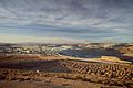
Rio Tinto Boron mine and plant, 2012
-
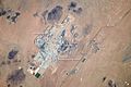
Boron (right center) and the Rio Tinto Borax mine from ISS, 2013


See also
 In Spanish: Boron (California) para niños
