
Boulder County, Colorado facts for kids
Quick facts for kids
Boulder County
|
||
|---|---|---|
.jpg)
Boulder County Courthouse
|
||
|
||

Location within the U.S. state of Colorado
|
||
 Colorado's location within the U.S. |
||
| Country | ||
| State | ||
| Founded | November 1, 1861 | |
| Named for | large granite boulders in area | |
| Seat | Boulder | |
| Largest city | Boulder | |
| Area | ||
| • Total | 740 sq mi (1,900 km2) | |
| • Land | 726 sq mi (1,880 km2) | |
| • Water | 14 sq mi (40 km2) 1.9%% | |
| Population | ||
| • Estimate
(2020)
|
330,758 | |
| • Density | 460/sq mi (176/km2) | |
| Time zone | UTC−7 (Mountain) | |
| • Summer (DST) | UTC−6 (MDT) | |
| Congressional districts | 2nd, 4th | |

Boulder County is a county located in the U.S. state of Colorado of the United States. As of the 2020 census, the population was 330,758. The most populous municipality in the county and the county seat is Boulder.
Boulder County comprises the Boulder, CO Metropolitan Statistical Area, which is included in the Denver–Aurora, CO Combined Statistical Area.
Contents
History
Boulder County was one of the original 17 counties created by the Territory of Colorado on November 1, 1861. The county was named for Boulder City and Boulder Creek, so named because of the abundance of boulders in the area. Boulder County retains essentially the same borders as in 1861, although a 27.5 square miles (71.2 km2) of its southeastern corner and its approximate population of 40,000 became part of the City and County of Broomfield in 2001.
Geography

According to the U.S. Census Bureau, the county has a total area of 740 square miles (1,900 km2), of which 726 square miles (1,880 km2) is land and 14 square miles (36 km2) (1.9%) is water.
Adjacent counties
- Larimer County, Colorado – north
- Weld County, Colorado – east
- City and County of Broomfield, Colorado – southeast
- Jefferson County, Colorado – south
- Gilpin County, Colorado – south
- Grand County, Colorado – west
National protected areas
- Arapaho National Forest
- Roosevelt National Forest
- Indian Peaks Wilderness
- James Peak Wilderness
Rocky Mountain National Park is in Boulder County, Larimer County, and Grand County. Longs Peak, the park's highest summit at 4,345 meters (14,255 feet) elevation, is located in Boulder County.
State protected area
Scenic trails and byways
- Continental Divide National Scenic Trail
- Peak to Peak Scenic and Historic Byway
Historic district
Demographics
| Historical population | |||
|---|---|---|---|
| Census | Pop. | %± | |
| 1870 | 1,939 | — | |
| 1880 | 9,723 | 401.4% | |
| 1890 | 14,082 | 44.8% | |
| 1900 | 21,544 | 53.0% | |
| 1910 | 30,330 | 40.8% | |
| 1920 | 31,861 | 5.0% | |
| 1930 | 32,456 | 1.9% | |
| 1940 | 37,438 | 15.4% | |
| 1950 | 48,296 | 29.0% | |
| 1960 | 74,254 | 53.7% | |
| 1970 | 131,889 | 77.6% | |
| 1980 | 189,625 | 43.8% | |
| 1990 | 226,374 | 19.4% | |
| 2000 | 271,651 | 20.0% | |
| 2010 | 294,567 | 8.4% | |
| 2020 | 330,758 | 12.3% | |
| U.S. Decennial Census 1790-1960 1900-1990 1990-2000 2010-2020 |
|||
As of the census of 2000, there were 271,651 people, 114,680 households, and 68,808 families residing in the county. The population density was 392 people per square mile (151/km2). There were 119,900 housing units at an average density of 162 per square mile (62/km2). The racial makeup of the county was 88.54% White, 0.88% Black or African American, 0.61% Native American, 3.06% Asian, 0.06% Pacific Islander, 4.67% from other races, and 2.18% from two or more races. 10.46% of the population were Hispanic or Latino of any race.
There were 114,680 households, out of which 30.70% had children under the age of 18 living with them, 48.90% were married couples living together, 7.70% had a female householder with no husband present, and 40.00% were non-families. 26.30% of all households were made up of individuals, and 5.50% had someone living alone who was 65 years of age or older. The average household size was 2.47 and the average family size was 3.03.
In the county, the population was spread out, with 22.90% under the age of 18, 13.40% from 18 to 24, 33.60% from 25 to 44, 22.30% from 45 to 64, and 7.80% who were 65 years of age or older. The median age was 33 years. For every 100 females, there were 102.20 males. For every 100 females age 18 and over, there were 101.70 males.
In 2014, the median income for a household in the county was $69,407, and the median income for a family was $94,938. Males had a median income of $65,489 versus $48,140 for females. About 7.0% of families and 14.6% of the population were below the poverty line, including 14.6% of those under age 18 and 5.9% of those age 65 or over.
In 2017, Bloomberg ranked the Boulder metropolitan area as the top "brain" area in the US.
Communities

Cities
- Boulder
- Lafayette
- Longmont (partly in Weld County)
- Louisville
Towns
- Erie (partly in Weld County)
- Jamestown
- Lyons
- Nederland
- Superior (partly in Jefferson County)
- Town of Ward
Census-designated places
- Allenspark
- Altona
- Bark Ranch
- Bonanza Mountain Estates
- Coal Creek (partly in Gilpin County and Jefferson County)
- Crisman
- Eldora
- Eldorado Springs
- Glendale
- Gold Hill
- Gunbarrel
- Hidden Lake
- Lazy Acres
- Leyner
- Mountain Meadows
- Niwot
- Paragon Estates
- Pine Brook Hill
- Seven Hills
- St. Ann Highlands
- Sugarloaf
- Sunshine
- Tall Timber
- Valmont
Other unincorporated communities
Images for kids
-
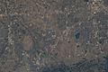
View of the eastern and southern borders of Boulder County and adjacent areas in Weld, Broomfield, and Jefferson counties, with north oriented to the left. The city of Boulder is near the lower border. Taken from the International Space Station on July 1, 2022.

See also
 In Spanish: Condado de Boulder para niños
