Bowling Green, Indiana facts for kids
Quick facts for kids
Bowling Green
|
|
|---|---|
 |
|
| Country | United States |
| State | Indiana |
| County | Clay |
| Township | Washington |
| Elevation | 653 ft (199 m) |
| Time zone | UTC-5:00 (EST) |
| • Summer (DST) | UTC-5:00 (EDT) |
| ZIP code |
47833
|
| Area code(s) | 812 |
| FIPS code | 18-06832 |
| GNIS feature ID | 431404 |
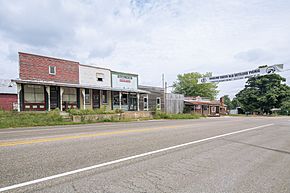
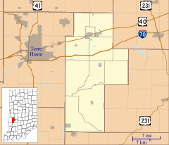
Bowling Green is an unincorporated community in Washington Township, Clay County, Indiana. It is part of the Terre Haute Metropolitan Statistical Area.
Contents
History
The first post office was established at Bowling Green in 1825. Bowling Green was incorporated as a town in 1869. According to one source, it was probably named after Bowling Green, Virginia.
Geography
Bowling Green is located at 39°22′59″N 87°00′42″W / 39.38306°N 87.01167°W.
Climate
Climate is characterized by relatively high temperatures and evenly distributed precipitation throughout the year. The Köppen Climate Classification subtype for this climate is "Cfa". (Humid Subtropical Climate).
Demographics
| Historical population | |||
|---|---|---|---|
| Census | Pop. | %± | |
| 1850 | 318 | — | |
| 1860 | 466 | 46.5% | |
| 1870 | 606 | 30.0% | |
| 1880 | 572 | −5.6% | |
| 1890 | 467 | −18.4% | |
| 1900 | 432 | −7.5% | |
| 1910 | 336 | −22.2% | |
| 1920 | 273 | −18.7% | |
| 1930 | 257 | −5.9% | |
| 1940 | 219 | −14.8% | |
| 1950 | 235 | 7.3% | |
| 1960 | 229 | −2.6% | |
| U.S. Decennial Census | |||
Bowling Green appeared on U.S. Census returns between 1850 and 1960. Its population peaked in 1870, when it had a reported 606 inhabitants.


