
Brattleboro, Vermont facts for kids
Quick facts for kids
Brattleboro, Vermont
|
|
|---|---|

The Gothic Revival Municipal Center (1884), built as Brattleboro's High School, served the town in that capacity until 1951
|
|
| Motto(s):
The One and Only Brattleboro
|
|

Brattleboro, Vermont
Location in Vermont

Brattleboro, Vermont
Location in the United States
|
|
| Country | |
| State | |
| County | Windham |
| Chartered | 1753 |
| Government | |
| • Type | Municipal |
| Area | |
| • Total | 32.4 sq mi (84.0 km2) |
| • Land | 32.0 sq mi (82.9 km2) |
| • Water | 0.5 sq mi (1.2 km2) |
| Elevation | c. 200-1,768 ft (c. 61-539 m) |
| Population
(2020)
|
|
| • Total | 12,184 |
| • Density | 376.0/sq mi (145.05/km2) |
| Time zone | UTC−5 (Eastern (EST)) |
| • Summer (DST) | UTC−4 (EDT) |
| ZIP Codes |
05301–05304
|
| Area code(s) | 802 |
| FIPS code | 50-07900 |
| GNIS feature ID | 1462049 |
| Website | www.brattleboro.org |
Brattleboro, originally Brattleborough, is a town in Windham County, Vermont, United States. The most populous municipality abutting Vermont's eastern border with New Hampshire, which is the Connecticut River, Brattleboro is located about 10 miles (16 km) north of the Massachusetts state line, at the confluence of Vermont's West River and the Connecticut. As of the 2020 Census, the population was 12,184.
Marlboro College Center for Graduate and Professional Studies and SIT Graduate Institute were located in the town until 2020. There are satellite campuses of three colleges as well: Community College of Vermont, Union Institute and University, and Vermont Technical College. The town is home to the New England Center for Circus Arts and the Vermont Jazz Center.
The Brattleboro Retreat, a not-for-profit psychiatric hospital, is also located in the town.
Contents
History

Abenaki land
Because Native Americans in the region tended to name places and regions after their rivers or watersheds, the site of today's Brattleboro, the confluence of the West River and the Connecticut River, was called 'Wantastiquet' by the Abenaki people, a name meaning, according to various translations, "lost river", "river that leads to the west", or "river of the lonely way". Today known only by its English-translated name, the West River remains demarcated by New Hampshire's towering Mount Wantastiquet, directly opposite its mouth, and Lake Wantastiquet, near where it rises at its source. The Abenaki would transit this area annually between Missisquoi (their summer hunting grounds near the current-day town of Swanton) in northwestern Vermont, and Squakheag (their winter settlement or camps) near what is now Northfield, Massachusetts. The specific Abenaki band who lived here and traversed this place were called Sokoki, meaning "people who go their own way" or "people of the lonely way". The Abenaki's inclusive name for what is now Vermont was "Ndakinna" ("our land"), and in the 17th and 18th centuries, as more Europeans moved into the region, their often vigorous measures of self-defense culminated in Dummer's War (also known variously as Greylock's War, Three Years War, Lovewell's War, the 4th Indian War, and in Maine as Father Rasle's War). Most Abenaki allied with the French during this period, and following what is now known as the French and Indian War (1754–1763), they were largely driven north or fled into Quebec, further opening the way for English – and later United States – settlements in the area.
Frontier fort
To defend the Massachusetts Bay Colony against Chief Gray Lock and others during Dummer's War, the Massachusetts General Court voted on December 27, 1723 to build a blockhouse and stockade on the Connecticut River near the site of what would later become known as Brattleboro. Lieutenant-governor William Dummer signed the measure, and construction of Fort Dummer began on February 3, 1724. It was completed before summer. On October 11 of that year, the French attacked the fort and killed some soldiers. In 1725, Dummer's War ended.
By 1728, and in subsequent peaceful periods, the fort served as a trading post for commerce among the colonial settlers and the Indians. But violence flared up from time to time throughout the first half of the 18th century. In 1744, what became known as King George's War broke out, lasting until 1748. During this period a small body of British colonial troops were posted at the fort, but after 1750 this was considered unnecessary.
Although the area was originally part of the Equivalent Lands, the township became one of the New Hampshire grants, and was chartered (founded) as such on December 26, 1753, by Governor Benning Wentworth. It was named Brattleborough, after Colonel William Brattle, Jr. of Boston, a principal proprietor. Ironically there is no record that Brattle ever visited the locality, and settlement activities remained tentative until after the 1763 Treaty of Paris, when France abandoned their claims to Vermont, part of the region which they had called New France.
Hostilities having ceased, Brattleboro developed quickly in peacetime, and soon was second to none in the state for business and wealth. In 1771, Stephen Greenleaf opened Vermont's first store in the east village, and in 1784, a post office was established. A bridge was built across the Connecticut River to Hinsdale, New Hampshire in 1804. In 1834, the Brattleboro Retreat, then called the Vermont Asylum for the Insane, was established through a generous bequest by Hinsdale, NH's Anna Marsh. In 1844 the Brattleboro Hydropathic Establishment was opened by Dr. Robert Wesselhoeft; this was the third 'water cure' establishment in the country, utilizing waters from a spring near the current downtown fire station. Until the "Water Cure" closed in 1871, the town was widely known as a curative health resort.


Mill town
Whetstone Falls, very close to where Brattleboro's Whetstone Brook flows into the Connecticut River, was a handy source of water power for watermills, initially a sawmill and a gristmill. By 1859, when the population had reached 3,816, Brattleboro had a woolen textile mill, a paper mill, a manufacturer of papermaking machinery, a factory making melodeons, two machine shops, a flour mill, a carriage factory, and four printing establishments. Connected by the Vermont & Massachusetts Railroad and the Vermont Valley Railroad, the town prospered as a regional center for trade in commodities including grain, lumber, turpentine, tallow and pork. In 1888, the spelling of the town's name was shortened to Brattleboro.
The Estey Organ company, the largest organ manufacturer in the United States, operated in Brattleboro for about a century beginning in 1852. The company's main factory was located southwest of downtown Brattleboro, on the south side of Whetstone Brook between Birge and Organ Streets. At its height, the complex had more than 20 buildings, many of which were interconnected by raised walkways and covered bridges. One of the buildings now houses the Estey Organ Museum. The entire surviving complex was listed on the National Register of Historic Places in 1980, both for its architecture, and as a major economic force in Brattleboro for many years.
British author Rudyard Kipling settled in Brattleboro after marrying a young Brattleboro woman, Carrie Balestier, in 1892. The couple built a home called Naulakha (Rudyard Kipling House), just over the town line to the north in neighboring Dummerston. Kipling wrote The Jungle Book and other works there. He also wrote about local life in the early 1890s: heavy snowfalls, ox-teams drawing sledges, and people in the small towns beset with what he called a "terrifying intimacy" about each other's lives. He recorded the death of men who had left, going to seek their fortunes in the cities or out west, and the consequent loneliness and depression in the lives of local women; the long length of the workday for farmers, even in winter, often for lack of help; and the abandonment of farms.
The first person ever to receive a Social Security benefit check, issued on January 31, 1940 was Ida May Fuller from Brattleboro.
Geography
According to the United States Census Bureau, the town has a total area of 32.5 square miles (84.0 km2), of which 32.0 square miles (82.9 km2) is land and 0.5 square mile (1.2 km2, 1.42%) is water. Brattleboro is drained by the West River, Ames Hill Brook and Whetstone Brook. The town is in the Connecticut River Valley, and its eastern boundary (and the Vermont state line) is the western bank of the Connecticut River. Hills and mountains surround the town.
Climate
Brattleboro experiences a humid continental climate (Köppen Dfa) with cold, snowy winters and hot, humid summers. The town can experience snowfall as early as November and as late as April, and in the adjacent mountains and high country as late as May. Nor'easters often come with the potential of dumping a foot or more of snow on Brattleboro when they move through; such storms are not uncommon during the winter months. Summers are warm to hot and generally humid, with abundant sunshine and heavy showers and thunderstorms associated with passing cold fronts. Tornadoes are rare.
The record high is 100 °F (38 °C), set in 1955, and the record low is −33 °F (−36 °C), set in 1958. In terms of average annual precipitation, May is typically the wettest month, and February is the driest. Brattleboro averages 92.58 inches (235 cm) of snow annually.
Brattleboro lies in USDA plant hardiness zone 5a.
| Climate data for Brattleboro, Vermont | |||||||||||||
|---|---|---|---|---|---|---|---|---|---|---|---|---|---|
| Month | Jan | Feb | Mar | Apr | May | Jun | Jul | Aug | Sep | Oct | Nov | Dec | Year |
| Record high °F (°C) | 62 (17) |
65 (18) |
83 (28) |
97 (36) |
95 (35) |
100 (38) |
99 (37) |
100 (38) |
100 (38) |
91 (33) |
78 (26) |
68 (20) |
100 (38) |
| Average high °F (°C) | 32 (0) |
36 (2) |
45 (7) |
57 (14) |
70 (21) |
79 (26) |
84 (29) |
82 (28) |
73 (23) |
62 (17) |
49 (9) |
36 (2) |
59 (15) |
| Average low °F (°C) | 11 (−12) |
13 (−11) |
24 (−4) |
34 (1) |
45 (7) |
54 (12) |
59 (15) |
57 (14) |
49 (9) |
37 (3) |
29 (−2) |
18 (−8) |
36 (2) |
| Record low °F (°C) | −30 (−34) |
−33 (−36) |
−19 (−28) |
5 (−15) |
22 (−6) |
31 (−1) |
39 (4) |
36 (2) |
24 (−4) |
10 (−12) |
−16 (−27) |
−24 (−31) |
−33 (−36) |
| Average precipitation inches (mm) | 3.92 (100) |
3.15 (80) |
3.94 (100) |
3.97 (101) |
4.32 (110) |
4.07 (103) |
3.87 (98) |
4.20 (107) |
3.78 (96) |
4.03 (102) |
4.13 (105) |
3.69 (94) |
47.07 (1,196) |
| Source: The Weather Channel | |||||||||||||
Demographics
| Historical population | |||
|---|---|---|---|
| Census | Pop. | %± | |
| 1790 | 1,589 | — | |
| 1800 | 1,867 | 17.5% | |
| 1810 | 1,891 | 1.3% | |
| 1820 | 2,017 | 6.7% | |
| 1830 | 2,141 | 6.1% | |
| 1840 | 2,623 | 22.5% | |
| 1850 | 3,816 | 45.5% | |
| 1860 | 3,855 | 1.0% | |
| 1870 | 4,933 | 28.0% | |
| 1880 | 5,880 | 19.2% | |
| 1890 | 6,862 | 16.7% | |
| 1900 | 6,640 | −3.2% | |
| 1910 | 7,541 | 13.6% | |
| 1920 | 8,332 | 10.5% | |
| 1930 | 9,816 | 17.8% | |
| 1940 | 10,983 | 11.9% | |
| 1950 | 11,522 | 4.9% | |
| 1960 | 11,734 | 1.8% | |
| 1970 | 12,239 | 4.3% | |
| 1980 | 11,886 | −2.9% | |
| 1990 | 12,241 | 3.0% | |
| 2000 | 12,005 | −1.9% | |
| 2010 | 12,046 | 0.3% | |
| 2020 | 12,184 | 1.1% | |
| U.S. Decennial Census | |||
As of the census of 2010, there were 12,046 people, 5,364 households, and 2,880 families residing in the town. Almost all of the population is concentrated in two census-designated places identified in the town: Brattleboro and West Brattleboro. The results of recent censuses indicate very little change in the overall number of people living in the town. Despite this, Brattleboro remains the most populous town along Vermont's eastern border.
The population density of the town was 375.3 people per square mile (144.9/km2). There were 5,686 housing units at an average density of 177.7 per square mile (68.6/km2). The racial makeup of the town was 92.1% White, 1.9% Black or African American, 0.3% Native American, 2.2% Asian, 0.04% Pacific Islander, 0.6% from other races, and 2.8% from two or more races. Hispanic or Latino of any race were 2.7% of the population.
There were 5,364 households, out of which 27.2% had children under the age of 18 living with them, 37.8% were married couples living together, 12.8% had a female householder with no husband present, and 46.3% were non-families. 37.8% of all households were made up of individuals, and 13.3% had someone living alone who was 65 years of age or older. The average household size was 2.15 and the average family size was 2.84.
In the town, the population was spread out, with 22.3% under the age of 18, 6.6% from 18 to 24, 29.2% from 25 to 44, 25.3% from 45 to 64, and 16.6% who were 65 years of age or older. The median age was 40 years. For every 100 females, there were 84.0 males. For every 100 females age 18 and over, there were 79.9 males.
The median income for a household in the town was $31,997, and the median income for a family was $44,267. Males had a median income of $31,001 versus $25,329 for females. The per capita income for the town was $19,554. About 9.2% of families and 13.1% of the population were below the poverty line, including 18.0% of those under age 18 and 9.2% of those age 65 or over.
Arts and culture


Brattleboro has a thriving arts community. It was listed recently in John Villani's book The 100 Best Small Art Towns in America, in which it was ranked #9 among 'arts towns' with a population of 30,000 or under.
On the first Friday of every month, an event known as Gallery Walk is held, in which galleries, artists, and arts organizations open their doors to the public to display new work or hold performances. Included in the organizations that participate are the Brattleboro Museum and Art Center, the Hooker-Dunham Theater and Gallery, the In-Sight Photography Project, River Gallery School, Through the Music, and the Windham Art Gallery.
Other notable arts organizations in Brattleboro include the Brattleboro Music Center, the Vermont Theatre Company, the New England Youth Theater, the Brattleboro Women's Chorus, the New England Center for Circus Arts (NECCA), the Vermont Performance Lab, and the Vermont Jazz Center.
Annual events
- The Winter Carnival in February
- Harris Hill ski jumping competition in February
- Women's Film Festival in March
- Maple Open House Weekend in March
- River Gallery School benefit auction in March
- Taste of the Town in May
- Slow Living Summit, late May or early June, just prior to Strolling of the Heifers weekend
- The Strolling of the Heifers parade and festival, the first full weekend in June
- Vermont Theatre Company's Shakespeare-in-the-Park in June and July
- Brattleboro Free Folk Festival, begun in 2003
- Brattleboro Literary Festival in October
- Brattleboro Film Festival first two weeks of November
Parks and recreation
The town operates and maintains the Gibson-Aiken Center, a large recreation and community activities facility, located downtown on Main Street, along with a number of parks and outdoor recreation centers, including Living Memorial Park, whose features include an outdoor swimming pool and a municipal skiing facility. There are bicycle lanes on Putney Road in the northern portion of town, on Guilford Street near Living Memorial Park, and on a short segment of Western Avenue in West Brattleboro. Open during the summer months, Fort Dummer State Park is named for, and located near, the original site of a Dummer's War-era stockade. The state park consists of 218 acres of protected forest, featuring hiking trails and a State campground, just south of the population center on wooded hills overlooking the Connecticut River.
Brattleboro sees a substantial seasonal influx of recreational skiers and snowboarders, many of them bound for the resorts at nearby Mount Snow and Stratton, but it is also a winter sports destination in and of itself. The town played an important role in the development and popularization of the skiing industry as a winter sport, with pioneering Brattleboro native and Dartmouth College alumnus Fred Harris, founder of the Dartmouth Outing Club (1909–10), also establishing the Brattleboro Outing Club (in 1922), contributing to the first North American use of motor-driven ski lifts, and building the Harris Hill olympic-scale ski jumping facility, the site of international competitions every February that still attract daring ski-jumping athletes from all over the world.
In popular culture
- Brattleboro is the setting for much of H. P. Lovecraft's story The Whisperer in Darkness.
- Brattleboro is the birthplace and burial site of William Morris Hunt, noted and influential 19th-century American painter.
- Brattleboro is mentioned once in David Foster Wallace's novel Infinite Jest.
- Brattleboro is the setting of multiple stories in Jacob M. Appel's collection Scouting for the Reaper.
- The popular Joe Gunther mystery series written by Archer Mayor is largely set in Brattleboro.
- Brattleboro is where the title character in Tom Taylor's play Our American Cousin meets his English relatives, leading to his trip to England where the events of the play take place.
- In the comedy movie Super Troopers, Lieutenant Arcot "Thorny" Ramathorn suggests that Brattleboro would be a good town to move to since his station is going to be shut down.
- The psychiatric hospital in the 2011 action movie Sucker Punch is located in Brattleboro.
- Brattleboro placed 11th on "The 20 Best Small Towns in America of 2012" list by Smithsonian Magazine in May 2012.
- In a Season 5 episode of HBO's Veep, New Hampshire congressional candidate Jonah Ryan gets into some trouble when he references Brattleboro during a Howard Dean-like speech.
Economy
Both a commercial and touristic gateway for the state of Vermont, Brattleboro is the first major town one encounters crossing northward by automobile from Massachusetts on Interstate 91, and is accessed via Vermont exits 1, 2, and 3 from that thoroughfare. It offers a mix of a rural atmosphere and urban amenities including a number of lodging establishments. Brattleboro also hosts art galleries, stores, and performance spaces, mostly located in the downtown area.
In 2007, after meeting qualifying criteria, the local Selectboard passed a resolution designating Brattleboro a Fair Trade Town, becoming the second Fair Trade certified town in the nation after Media, Pennsylvania.
C&S Wholesale Grocers, the northeast's largest regional food distributor, made its headquarters here until 2005, when they moved their administrative offices to Keene, New Hampshire; however, because of close proximity to Interstate 91, C&S still operates a large shipping and warehouse facility in Brattleboro near I-91's Exit 3.
Ehrmann Commonwealth Dairy is headquartered in Brattleboro and operates a dairy processing facility in the town that opened in 2011.
| Employer | Employees | Industry |
|---|---|---|
| C&S Wholesale Grocers | 1,200 | Grocery wholesale, distribution |
| Brattleboro Memorial Hospital | 400 | Healthcare |
| Brattleboro Retreat | 400 | Healthcare |
| Retreat Healthcare | 400 | Healthcare |
Development
The town's densely populated center is located near Vermont's lowest elevation point in the Connecticut river valley. Because of the surrounding steep hills there is very little flat land, and many of its buildings and houses are situated on steep hillsides, necessarily closely bunched together. This concentrated topography and population density have helped to create a semi-urban, cosmopolitan atmosphere in the downtown.
Since the 1950s, additional construction and development have expanded outside the concentrated downtown area; in the west, south, and north of the township. The southeast quarter of the town, near to and abutting the riverbank, is where its population has historically been the densest, and is composed largely of one- or two-family houses, with apartment buildings such as "triple deckers" interspersed among them. Commercial and industrial operations are concentrated along the north-south Canal Street (Route 5) artery. The town's high school and the Regional Career Center are also located in this section, as is Fort Dummer State Park, which is named after the first European settlers' 1724 stockade. The original Fort's site, however, was flooded in the early 20th century by a flood-control and hydro-electric dam built just downstream in Vernon, Vermont. An historical marker is located near the Fort's now-underwater site, on the west bank of the Connecticut River on Vernon Road (VT Route 142), at the corner of Cotton Mill Hill.
The western section of town, built up around Vermont's east-west Route 9, was formally designated a village in 2005. It is mostly lower-density residential in character, and features the state's largest mobile home park and several planned housing developments and subdivisions. Away from the Route 9 conduit, other parts of western Brattleboro and some areas north of the West River have a decidedly rural character, with dirt roads, sparse housing, wooded Green Mountains foothills, and the last few farms left in the town following the 1970s' decline of the dairy industry. At its peak, the immediate Brattleboro area had over 170 farms; there are now less than a dozen remaining.
The section of Brattleboro north of the West River, formerly farmland, was mostly subdivided and developed during the 1960s and 1970s following the construction of Interstate 91, which runs north-south through the town. The area has little residential development and is dominated by larger commercial and industrial establishments and suburban-style shopping areas along Putney Road, including seven chain hotels and motels located within a short distance of each other.
Brattleboro is also the headquarters of the Holstein/Friesian Cattle Association, which houses and maintains the worldwide registries for those two breeds.

Education
Brattleboro has a diverse mix of public and private primary, secondary and post-secondary schools and career centers. Sub-campuses of the Community College of Vermont and Vermont Technical College are located in Brattleboro; in the downtown's newly renovated Brooks House. Brattleboro is also home to the New England Academic Center of Union Institute and University, housed in the Marlboro College Graduate Center building.
SIT Graduate Institute, formerly known as the School for International Training, is a private higher education institution in northern Brattleboro. An outgrowth of The Experiment in International Living, which was founded in 1932 in nearby Putney, Vermont, the Graduate Institute offers master's degrees in several internationally-oriented concentrations. Its students and faculty hail from all regions of the globe, giving Brattleboro a decidedly eclectic and international flair, and its notable alumni include native Vermonter and 1997 Nobel Peace Prize laureate Jody Williams.
Brattleboro currently has three public K–6 elementary schools. They are:
- Green Street School
- Oak Grove School
- Academy School
There is one public middle school, the Brattleboro Area Middle School (BAMS), and one public high school, the Brattleboro Union High School (BUHS). The Windham Southeast Supervisory Union, which oversees the public school system in the southeastern corner of Windham County, also administers a dedicated vocational education unit, the Windham Regional Career Center. Oak Meadow, a K–12 homeschool curriculum provider and distance learning school is also based out of downtown Brattleboro.
Brooks Memorial Library is Brattleboro's partially municipally-funded and modestly-endowed library. It also houses a town historical archive and more than a few excellent fine art paintings and sculptures.
Infrastructure
Transportation
Roads and highways


Brattleboro is crossed by six highways, including one Interstate highway. They are:
 Interstate 91
 U.S. Route 5 ("Connecticut River Byway")
 Vermont Route 9 ("Molly Stark Trail")
 Vermont Route 30
 Vermont Route 119
 Vermont Route 142
Vermont Route 9 runs from the New York border with Vermont, west of Bennington, traverses the southern backbone of the Green Mountains well west of Brattleboro, and eventually arrives in the heart of Brattleboro's downtown as High Street. Its other local names are The Molly Stark Trail, Marlboro Road, Western Avenue, Main Street, and Putney Road. It meets I-91 at a partial cloverleaf interchange (from where it is Exit 2 from the Interstate), then as it advances eastward into downtown, it overlaps U.S. Route 5 at the intersection of Main and High Streets. The road then runs north with Main Street into Putney Road then to the traffic circle at Interstate 91's Exit 3 (connected to that highway via a trumpet interchange westward from this roundabout), where it diverges from Route 5 and runs eastward into New Hampshire, becoming New Hampshire Route 9.
U.S. Route 5 enters Brattleboro at its border with the town of Guilford and runs north-south, through downtown, eventually exiting Brattleboro at its northern border with the town of Dummerston. Route 5's local names are Canal Street, Main Street, and Putney Road. Southbound, Route 5 detours along Park Place and part of Linden Street, as part of a one-way 'traffic triangle' at the north end of Main Street. Route 5, designated throughout Vermont as the Connecticut River Byway, is the only scenic byway in Vermont to receive national byway status.
Scenic Vermont Route 30 has its southern terminus in Brattleboro at the intersection of Park Place and Linden Street. From this point, it runs for about 12 miles on a very gently graded roadbed along the West River's southern bank, affording a stunning vista and connecting Brattleboro with picturesque New England towns and recreational areas elsewhere in Windham County and Vermont. Its wide riverside paved shoulder makes it a favorite cycling route. Route 30 exits Brattleboro at its border with Dummerston and continues northwest along the West River. Its local names within Brattleboro are Linden Street and West River Road.
Interstate 91, originating in Connecticut and terminating at the Canada–U.S. border, runs north-south through town, arcing westward around the town center. Its first three Vermont exits are in Brattleboro: Exit 1 serves the southern part of town, Exit 2 serves the western section of town connecting to local ski areas via Route 9, and Exit 3 serves the northern section of town and neighboring southwest New Hampshire. I-91's majestic twin-structure West River Bridge is, as of 2015, being rebuilt with a completely new design.
Vermont Route 119 begins at a 5-way intersection locally known as "Malfunction Junction" with U.S. Route 5 and VT Route 142. Route 119's local name within Brattleboro is Bridge Street. It continues east with an at-grade crossing of the New England Central Railroad just before crossing into New Hampshire over the Connecticut River, whose border lies just 0.08 miles (0.13 km) from the road's western end.
Vermont Route 142 begins at Malfunction Junction (mentioned above), continuing southward, closely paralleling the New England Central Railroad for much of its length within town. Its local names are Vernon Street and Vernon Road, as it continues southward into the town of Vernon and eventually into Massachusetts.
Rail

Amtrak, the national passenger rail system, operates its Vermonter service daily through Brattleboro, connecting the town by rail with Washington, D.C. and St. Albans, Vermont and many stations in between. Brattleboro was recently part of a $70 million re-alignment of the Vermonter's route to the old Montrealer route, restoring passenger rail service between Brattleboro and the western Massachusetts cities of Northampton and Greenfield. Recent upgrades to railroad tracks in Massachusetts and Connecticut, to the south, have significantly reduced rail travel time to New York and points south.
Bus
Southeast Vermont Transit operates both the Current and the MOOver, local public transit bus routes.
Greyhound and Megabus operate long-distance bus routes.
Air
The closest small-craft airports to Brattleboro are the Deerfield Valley Regional Airport in West Dover to the west, and Dillant-Hopkins Airport in Keene, New Hampshire to the east. The closest airports (both within 70 miles (110 km) north of the town) offering regularly-scheduled domestic commercial flights include Lebanon Municipal Airport in West Lebanon, New Hampshire and the Rutland – Southern Vermont Regional Airport, close to Rutland. Both airports feature daily Cape Air flights to and from Boston and White Plains, New York. The closest airports with regularly-scheduled domestic and international flights are Bradley International Airport to the south, Manchester-Boston Regional Airport to the east, and Albany International Airport to the west, all of them less than two hours' driving distance from the town.

Fire department
The town of Brattleboro is protected by the Brattleboro Fire Department, founded in 1831 and located on Elliot Street in the downtown business district. There is also a sub-station in West Brattleboro. The Department's current Chief is Michael Bucossi.
Utilities
Brattleboro's electricity is supplied by Green Mountain Power. Brattleboro's surface water supply is the Pleasant Valley Reservoir, which the Pleasant Valley Water Plant siphons through Brattleboro at a daily average of 1.0 to 1.5 million gallons per day. Also, backup water pumps are adjacent to West River Road just north of the Brattleboro Retreat.
Cable television in Brattleboro is provided by Comcast. Comcast and Consolidated Communications also provide the town with landline phone and high speed Internet service.
Notable people
See: List of people from Brattleboro, Vermont
Images for kids
-
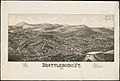
Lithograph of Brattleboro from 1886 by L.R. Burleigh with a list of landmarks
.jpg)
See also
 In Spanish: Brattleboro para niños
