
Bridgeport, Ohio facts for kids
Quick facts for kids
Bridgeport, Ohio
|
|
|---|---|
|
Village
|
|
| Nickname(s):
"Gateway to the West"
|
|

Location of Bridgeport, Ohio
|
|

Location of Bridgeport in Belmont County
|
|
| Country | United States |
| State | Ohio |
| County | Belmont |
| Township | Pease |
| Government | |
| • Type | Statutory Village |
| Area | |
| • Total | 1.38 sq mi (3.56 km2) |
| • Land | 1.37 sq mi (3.54 km2) |
| • Water | 0.01 sq mi (0.03 km2) |
| Elevation | 656 ft (200 m) |
| Population
(2010)
|
|
| • Total | 1,831 |
| • Estimate
(2019)
|
1,728 |
| • Density | 1,265.01/sq mi (488.27/km2) |
| Time zone | UTC-5 (Eastern (EST)) |
| • Summer (DST) | UTC-4 (EDT) |
| ZIP code |
43912
|
| Area code(s) | 740 |
| FIPS code | 39-08560 |
| GNIS feature ID | 1064487 |
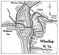
Bridgeport is a village in Belmont County, Ohio, United States. It lies across the Ohio River from Wheeling, West Virginia, and is connected by two bridges to Wheeling Island. The population was 1,831 at the 2010 census.
Contents
History
Bridgeport was originally known as Canton, and under the latter name was laid out in 1806 by Colonel Ebenezer Zane. The present name is for a bridge constructed near the town site in the 1810s.
Geography
Bridgeport is located at 40°4′20″N 80°44′37″W / 40.07222°N 80.74361°W (40.072092, −80.743542), along the Ohio River at the mouth of Wheeling Creek.
According to the United States Census Bureau, the village has a total area of 1.38 square miles (3.57 km2), of which 1.37 square miles (3.55 km2) is land and 0.01 square miles (0.03 km2) is water.
Demographics
| Historical population | |||
|---|---|---|---|
| Census | Pop. | %± | |
| 1830 | 169 | — | |
| 1840 | 329 | 94.7% | |
| 1860 | 641 | — | |
| 1870 | 1,178 | 83.8% | |
| 1880 | 2,395 | 103.3% | |
| 1890 | 3,369 | 40.7% | |
| 1900 | 3,963 | 17.6% | |
| 1910 | 3,974 | 0.3% | |
| 1920 | 3,977 | 0.1% | |
| 1930 | 4,655 | 17.0% | |
| 1940 | 4,853 | 4.3% | |
| 1950 | 4,309 | −11.2% | |
| 1960 | 3,824 | −11.3% | |
| 1970 | 3,001 | −21.5% | |
| 1980 | 2,642 | −12.0% | |
| 1990 | 2,318 | −12.3% | |
| 2000 | 2,186 | −5.7% | |
| 2010 | 1,831 | −16.2% | |
| 2019 (est.) | 1,728 | −5.6% | |
| U.S. Decennial Census | |||
2010 census
As of the census of 2010, there were 1,831 people, 810 households, and 472 families living in the village. The population density was 1,336.5 inhabitants per square mile (516.0/km2). There were 943 housing units at an average density of 688.3 per square mile (265.8/km2). The racial makeup of the village was 89.7% White, 6.9% African American, 0.2% Asian, 0.2% from other races, and 3.0% from two or more races. Hispanic or Latino of any race were 0.2% of the population.
There were 810 households, of which 25.4% had children under the age of 18 living with them, 40.2% were married couples living together, 13.3% had a female householder with no husband present, 4.7% had a male householder with no wife present, and 41.7% were non-families. 35.6% of all households were made up of individuals, and 14.9% had someone living alone who was 65 years of age or older. The average household size was 2.26 and the average family size was 2.91.
The median age in the village was 43.3 years. 19.5% of residents were under the age of 18; 9% were between the ages of 18 and 24; 23.5% were from 25 to 44; 30.7% were from 45 to 64; and 17.4% were 65 years of age or older. The gender makeup of the village was 48.8% male and 51.2% female.
Education
Bridgeport has a public library, a branch of the Belmont County District Library.
Notable people
- Johnny Blatnik, former professional baseball player
- Bobby Douglas, Olympic wrestler
- John Havlicek, Hall of Fame basketball player for Ohio State and Boston Celtics
- Bill Jobko, National Football League football player
- Joseph Henry Sharp, painter
- Thomas Clarke Theaker, Republican U.S. Representative from Ohio
- Bill White, Major League Baseball player
- John Todd Zimmer, leading ornithologist
Images for kids
-
Bridgeport and neighboring Wheeling in 1920

See also
 In Spanish: Bridgeport (Ohio) para niños
