
Broșteni, Suceava facts for kids
Quick facts for kids
Broșteni
|
||
|---|---|---|

Saint Nicholas Wooden Church in Broșteni
|
||
|
||

Location in Suceava County
|
||

Broșteni, Suceava
Location in Romania
|
||
| Country | ||
| County | Suceava | |
| Area | 424.40 km2 (163.86 sq mi) | |
| Population
(2011)
|
Lua error in Module:Wd at line 1,575: attempt to index field 'wikibase' (a nil value). | |
| Time zone | EET/EEST (UTC+2/+3) | |

| Historical population | ||
|---|---|---|
| Year | Pop. | ±% |
| 2002 | 6,603 | — |
| 2011 | 5,388 | −18.4% |
| Source: Romanian census data | ||
Broșteni is a town in Suceava County, in the historical region of Western Moldavia, northeastern Romania. Broșteni is the fourteenth largest urban settlement in the county, with a population of 5,388 inhabitants, according to the 2011 census. It was declared a town in 2004, along with seven other localities in Suceava County. The town administers the former villages of Hăleasa, Lungeni, and Neagra (which became neighborhoods in 2004), and Cotârgași, Dârmoxa, Frasin, Holda, Holdița, and Pietroasa (with the status of associated villages).
History
Broșteni is a former mining community located on the banks of the river Bistrița, between Bistrița Mountains and Stânișoara Mountains. It administers a total area of 424.40 km2 (163.86 sq mi) – the largest area being administered by a single locality in Suceava County. The national road between Vatra Dornei and Piatra Neamț is the main communication way for Broșteni, which is not connected to the national railway system.
Natives
- Mihai Băcescu
- Leon Mrejeriu
Gallery
-
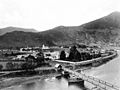
Broșteni, during the early 20th century

See also
 In Spanish: Broșteni (Suceava) para niños
