Brownfields, Louisiana facts for kids
Quick facts for kids
Brownfields, Louisiana
|
|
|---|---|

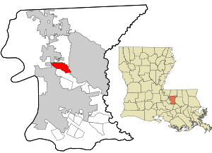
Location in East Baton Rouge Parish and the state of Louisiana.
|
|
| Country | United States |
| State | Louisiana |
| Parish | East Baton Rouge |
| Area | |
| • Total | 4.15 sq mi (10.74 km2) |
| • Land | 4.14 sq mi (10.73 km2) |
| • Water | 0.01 sq mi (0.01 km2) |
| Elevation | 62 ft (19 m) |
| Population
(2020)
|
|
| • Total | 5,145 |
| • Density | 1,242.15/sq mi (479.60/km2) |
| Time zone | UTC-6 (CST) |
| • Summer (DST) | UTC-5 (CDT) |
| Area code(s) | 225 |
| FIPS code | 22-10145 |
Brownfields is an unincorporated area and census-designated place (CDP) in East Baton Rouge Parish, Louisiana, United States. The population was 5,401 at the 2010 census. It is part of the Baton Rouge Metropolitan Statistical Area.
Geography
Brownfields is located north of the center of East Baton Rouge Parish and is bordered to the north by the city of Baker, to the east by Central, and to the southwest by Baton Rouge. Brownfields is 10 miles (16 km) northeast of downtown Baton Rouge. The border with Central is formed by the Comite River, a south-flowing tributary of the Amite River.
According to the United States Census Bureau, the Brownfields CDP has a total area of 4.1 square miles (10.7 km2), of which 0.01 square miles (0.02 km2), or 0.15%, is water.
Demographics
| Historical population | |||
|---|---|---|---|
| Census | Pop. | %± | |
| 2000 | 5,222 | — | |
| 2010 | 5,401 | 3.4% | |
| 2020 | 5,145 | −4.7% | |
|
|
|||
2020 census
| Race | Number | Percentage |
|---|---|---|
| White (non-Hispanic) | 862 | 16.75% |
| Black or African American (non-Hispanic) | 4,065 | 79.01% |
| Native American | 6 | 0.12% |
| Asian | 21 | 0.23% |
| Other/Mixed | 121 | 2.35% |
| Hispanic or Latino | 79 | 1.54% |
As of the 2020 United States census, there were 5,145 people, 2,027 households, and 1,337 families residing in the CDP.
Education
East Baton Rouge Parish Public Schools serves one portion of Brownfields. Most residents of the EBR section are zoned to Brownfields Elementary School, while a few are zoned to Sharon Hills Elementary School. For middle school students in the EBR schools section are divided between Northeast Middle School (Attendance Zone B) and Crestworth Middle School; the latter is operated by the Recovery School District of Louisiana, and the district-operated Park Forest Middle School is the alternate for the Crestworth zone. For senior high school students in the EBR schools section are divided between Northeast High School (Attendance Zone B) and Scotlandville High School.
Another portion of Brownfields is within the Central Community School System. Residents of that section are assigned to Bellingrath Hills School (grades PK-K), Tanglewood Elementary School (grades 1-2), Central Intermediate School (grades 3-5), Central Middle School (grades 6-8), Central High School (grades 9-12), all in Central.
History of schools
Prior to 2007 all residents were in EBR parish schools; Central schools left the EBR district that year.
Brownfields Elementary School served most of the community, while Sharon Hills Elementary served a portion. At that time one section of Brownfields was assigned to Central Middle, then an EBR parish-controlled school; while others were zoned to Crestworth Middle School, then controlled by EBR. At that time one section was assigned to Central High, then an EBR parish-controlled school; while others were zoned to Northeast High and Scotlandville High.
See also
 In Spanish: Brownfields para niños

