
Browning, Montana facts for kids
Quick facts for kids
Browning, Montana
|
|
|---|---|
| Town of Browning | |

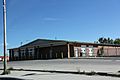
Downtown Browning in May 2011
|
|

Location of Browning, Montana
|
|
| Country | United States |
| State | Montana |
| County | Glacier |
| Area | |
| • Total | 0.28 sq mi (0.72 km2) |
| • Land | 0.28 sq mi (0.72 km2) |
| • Water | 0.00 sq mi (0.00 km2) |
| Elevation | 4,377 ft (1,334 m) |
| Population
(2020)
|
|
| • Total | 1,018 |
| • Density | 3,635.71/sq mi (1,413.89/km2) |
| Time zone | UTC-7 (Mountain (MST)) |
| • Summer (DST) | UTC-6 (MDT) |
| ZIP code |
59417
|
| Area code(s) | 406 |
| FIPS code | 30-10375 |
| GNIS feature ID | 0802063 |
Browning (Blackfeet: Iitoonio’p, "Indian Agency") is a town in Glacier County, Montana, United States. It is the headquarters for the Blackfeet Indian Reservation and the only incorporated town on the Reservation. The population was 1,018 at the 2020 census.
The town was named in 1885 for Commissioner of Indian Affairs Daniel M. Browning. The post office was established in 1895.
Contents
Geography
Browning is located at 48°33′25″N 113°0′52″W / 48.55694°N 113.01444°W (48.556917, -113.014571).
According to the United States Census Bureau, the town has a total area of 0.27 square miles (0.70 km2), all of it land.


Climate
From January 23, 1916, to January 24, 1916, the temperature fell 100 °F (56 °C) from 44 °F (7 °C) to -56 °F (-49 °C). This is the United States' and also the world record for the greatest temperature drop in 24 hours. Temperatures above 90 °F (32 °C) occur an average of 2 days annually, temperatures below 32 °F (0 °C) occur an average of 196 days annually, and those below 0 °F (−18 °C) occur an average of 32 days annually.
| Climate data for Browning (1894-1989) | |||||||||||||
|---|---|---|---|---|---|---|---|---|---|---|---|---|---|
| Month | Jan | Feb | Mar | Apr | May | Jun | Jul | Aug | Sep | Oct | Nov | Dec | Year |
| Record high °F (°C) | 66 (19) |
68 (20) |
72 (22) |
91 (33) |
93 (34) |
100 (38) |
99 (37) |
98 (37) |
94 (34) |
83 (28) |
72 (22) |
69 (21) |
100 (38) |
| Average high °F (°C) | 28.2 (−2.1) |
31.9 (−0.1) |
38.0 (3.3) |
50.5 (10.3) |
60.7 (15.9) |
68.1 (20.1) |
77.8 (25.4) |
76.0 (24.4) |
65.4 (18.6) |
55.2 (12.9) |
40.2 (4.6) |
32.2 (0.1) |
52.0 (11.1) |
| Average low °F (°C) | 8.0 (−13.3) |
11.2 (−11.6) |
16.9 (−8.4) |
27.3 (−2.6) |
35.5 (1.9) |
41.8 (5.4) |
46.1 (7.8) |
44.4 (6.9) |
37.5 (3.1) |
30.9 (−0.6) |
19.9 (−6.7) |
13.3 (−10.4) |
27.7 (−2.4) |
| Record low °F (°C) | −56 (−49) |
−46 (−43) |
−38 (−39) |
−14 (−26) |
1 (−17) |
21 (−6) |
24 (−4) |
19 (−7) |
0 (−18) |
−17 (−27) |
−39 (−39) |
−47 (−44) |
−56 (−49) |
| Average precipitation inches (mm) | 0.81 (21) |
0.70 (18) |
0.81 (21) |
1.09 (28) |
2.00 (51) |
2.77 (70) |
1.51 (38) |
1.39 (35) |
1.53 (39) |
0.83 (21) |
0.81 (21) |
0.72 (18) |
14.97 (381) |
| Average snowfall inches (cm) | 9.5 (24) |
8.3 (21) |
8.9 (23) |
6.6 (17) |
2.3 (5.8) |
0.4 (1.0) |
0.1 (0.25) |
0.1 (0.25) |
2.6 (6.6) |
4.2 (11) |
7.4 (19) |
9.1 (23) |
59.5 (151.9) |
Demographics
| Historical population | |||
|---|---|---|---|
| Census | Pop. | %± | |
| 1920 | 986 | — | |
| 1930 | 1,172 | 18.9% | |
| 1940 | 1,825 | 55.7% | |
| 1950 | 1,691 | −7.3% | |
| 1960 | 2,011 | 18.9% | |
| 1970 | 1,700 | −15.5% | |
| 1980 | 1,226 | −27.9% | |
| 1990 | 1,170 | −4.6% | |
| 2000 | 1,065 | −9.0% | |
| 2010 | 1,016 | −4.6% | |
| 2020 | 1,018 | 0.2% | |
| U.S. Decennial Census | |||
2010 census
As of the census of 2010, there were 1,016 people, 360 households, and 243 families living in the town. The population density was 3,763.0 inhabitants per square mile (1,452.9/km2). There were 394 housing units at an average density of 1,459.3 per square mile (563.4/km2). The racial makeup of the town was 5.5% White, 92.7% Native American, and 1.8% from two or more races. Hispanic or Latino of any race were 3.7% of the population.
There were 360 households, of which 45.3% had children under the age of 18 living with them, 28.6% were married couples living together, 28.6% had a female householder with no husband present, 10.3% had a male householder with no wife present, and 32.5% were non-families. 27.2% of all households were made up of individuals, and 8% had someone living alone who was 65 years of age or older. The average household size was 2.82 and the average family size was 3.43.
The median age in the town was 29.8 years. 33.1% of residents were under the age of 18; 9.6% were between the ages of 18 and 24; 23.6% were from 25 to 44; 23% were from 45 to 64; and 10.7% were 65 years of age or older. The gender makeup of the town was 46.1% male and 53.9% female.
Transportation
- US Route 2 comes into Browning from East Glacier from the west.
- US Route 89 comes into Browning from St. Mary from the north.
- The two US Routes meet on the western end of Browning and run through town together, splitting on the eastern end of town, with US 2 headed east towards Cut Bank and Shelby and US 89 headed south towards Choteau and Great Falls.
- US Route 87 ran through Browning until 1934, when US 89 replaced its original routing north of Great Falls. US 87 then ended in Great Falls until 1945, when it was changed to run from Great Falls to Havre.
- Amtrak's Chicago to Portland/Seattle Empire Builder serves Browning from October to April at a station just south of town. East Glacier receives passengers just a few miles west, from April to October.
Popular culture
Browning is the setting for the TV-series The X-Files episode "Shapes".
Education
Browning Public Schools educates students from kindergarten through 12th grade. They are known as the Indians. Browning High School is a Class A school.
Browning is home to Blackfeet Community College.
Notable people
- Shannon Augare, politician
- Michele Binkley, politician
- Frosty Boss Ribs, politician
- Jackie Larson Bread, beadwork artist
- Gladys Cardiff, Native American poet and academic
- Elouise Pepion Cobell, MacArthur Grant winner, tribal elder and activist, banker, rancher, and lead plaintiff in Cobell v. Salazar
- Lila Walter Evans, politician
- Lily Gladstone, actress
- Bonnie HeavyRunner, academic
- Joe Hipp, professional boxer
- Carol Juneau, politician and educator
- Denise Juneau, politician
- Darrell Kipp, educator, documentary filmmaker, and historian
- Terran Last Gun, artist
- Zahn McClarnon, actor
- Earl Old Person, honorary lifetime chief of the Blackfeet Nation
- Albert Racine, artist
- Steve Reevis, actor known for Dances with Wolves, Geronimo: An American Legend, Fargo, and The Missing
- Hart Merriam Schultz, artist
- Robert Scriver, sculptor and museum owner
- Marvin Weatherwax Jr., politician
- James Welch, poet and author
- Tyson Running Wolf, member of the Montana House of Representatives
- Alfred Young Man, artist, writer, and educator
Images for kids
-
Post office
-
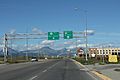
Former Intersection of U.S. Route 2 and U.S. Route 89 in Browning; this intersection is now a roundabout.
-
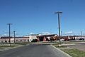
Blackfeet Community Hospital


See also
 In Spanish: Browning (Montana) para niños
