Brownsville, Ohio facts for kids
Quick facts for kids
Brownsville, Ohio
|
|
|---|---|

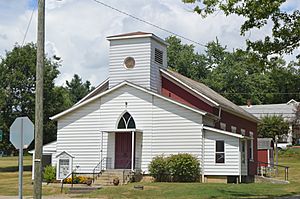
Brownsville United Methodist Church
|
|

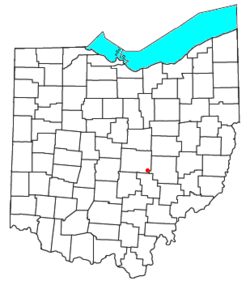
Location of Brownsville in Ohio
|
|
| Country | United States |
| State | Ohio |
| County | Licking |
| Township | Bowling Green |
| Area | |
| • Total | 0.89 sq mi (2.31 km2) |
| • Land | 0.89 sq mi (2.31 km2) |
| • Water | 0 sq mi (0.0 km2) |
| Elevation | 948 ft (289 m) |
| Population
(2010)
|
|
| • Total | 220 |
| • Density | 247/sq mi (95.4/km2) |
| Time zone | UTC-5 (Eastern (EST)) |
| • Summer (DST) | UTC-4 (EDT) |
| ZIP Code |
43721
|
| FIPS code | 39-09596 |
| GNIS feature ID | 1048310 |
Brownsville is an unincorporated community and census-designated place (CDP) in northeastern Bowling Green Township, Licking County, Ohio, United States. As of the 2010 census, it had a population of 220. It lies at the intersection of U.S. Route 40 with State Route 668.
History
Brownsville had its start when the National Road was extended to that point. The community was laid out in 1829. Brownsville was named for its founder, Adam Brown. A post office has been in operation since 1830.
Flint Ridge State Memorial is three miles north of Brownsville.
Notable person
- William M. Morgan, congressman
See also
 In Spanish: Brownsville (Ohio) para niños

All content from Kiddle encyclopedia articles (including the article images and facts) can be freely used under Attribution-ShareAlike license, unless stated otherwise. Cite this article:
Brownsville, Ohio Facts for Kids. Kiddle Encyclopedia.
