Broxburn, Queensland facts for kids
Quick facts for kids BroxburnQueensland |
|||||||||||||||
|---|---|---|---|---|---|---|---|---|---|---|---|---|---|---|---|

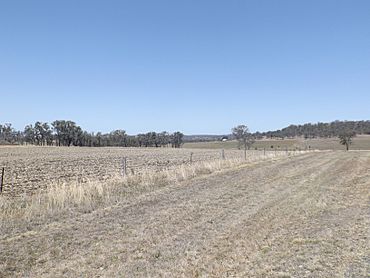
Farms along Southbrook Road, 2014
|
|||||||||||||||
| Population | 153 (2016 census) | ||||||||||||||
| • Density | 4.781/km2 (12.38/sq mi) | ||||||||||||||
| Postcode(s) | 4356 | ||||||||||||||
| Area | 32.0 km2 (12.4 sq mi) | ||||||||||||||
| Time zone | AEST (UTC+10:00) | ||||||||||||||
| Location |
|
||||||||||||||
| LGA(s) | Toowoomba Region | ||||||||||||||
| State electorate(s) | Condamine | ||||||||||||||
| Federal Division(s) | |||||||||||||||
|
|||||||||||||||
Broxburn is a rural locality in the Toowoomba Region, Queensland, Australia. In the 2016 census Broxburn had a population of 153 people.
Geography
The northwest boundary follows the Gore Highway. Close to the northern boundary is the Millmerran railway line which had a stop at Broxburn.
History
The Broxburn Provisional School opened on 13 June 1898. In 1909, it became Broxburn State School. It closed in 1959.
Economy
There are a number of homesteads in the locality, including:
- Albion Park (27°43′00″S 151°41′25″E / 27.7167°S 151.6902°E)
- Dalhiem Park (27°42′23″S 151°41′27″E / 27.7064°S 151.6909°E)
- East Lynne (27°43′00″S 151°43′10″E / 27.7166°S 151.7195°E)
- Glenhaven (27°41′32″S 151°40′52″E / 27.6923°S 151.6811°E)
- Greystones (27°41′38″S 151°42′04″E / 27.6939°S 151.7012°E)
- Helgar Park (27°41′51″S 151°41′51″E / 27.6976°S 151.6976°E)
- Highland View (27°43′00″S 151°41′36″E / 27.7166°S 151.6934°E)
- Hulilou (27°42′14″S 151°41′45″E / 27.7039°S 151.6957°E)
- Nevertire (27°42′26″S 151°41′27″E / 27.7072°S 151.6907°E)
- Peppertree (27°41′52″S 151°42′33″E / 27.6978°S 151.7093°E)
- Rockmount (27°44′04″S 151°43′11″E / 27.7344°S 151.7198°E)
- Rogar Park (27°45′05″S 151°42′01″E / 27.7515°S 151.7004°E)
- Tullawood (27°43′48″S 151°40′35″E / 27.7301°S 151.6763°E)
Education
There are no schools in Broxburn. The nearest government primary schools are Pittsworth State School in neighbouring Pittsworth to the west and Southbrook Central State School in neighbouring Southbrook to the north-east. The nearest government secondary school is Pittsworth State High School in Pittsworth.


