
Bruny Island facts for kids
|
Native name:
Lunawanna Allonah
|
|
|---|---|
 |
|

Location of the Bruny Island in Tasmania
|
|
| Etymology | Bruni d'Entrecasteaux |
| Geography | |
| Location | Tasman Sea |
| Coordinates | 43°22′S 147°17′E / 43.367°S 147.283°E |
| Total islands | 2 |
| Area | 362 km2 (140 sq mi) |
| Highest elevation | 571 m (1,873 ft) |
| Highest point | Mount Mangana |
| Administration | |
| State | Tasmania |
| LGA | Kingborough Council |
| Demographics | |
| Population | 600 |
| Pop. density | 1.6 /km2 (4.1 /sq mi) |
Bruny Island (Nuenonne: Lunawanna-alonnah) is a 362-square-kilometre (140 sq mi) island located off the south-eastern coast of Tasmania, Australia. The island is separated from the Tasmanian mainland by the D'Entrecasteaux Channel, and its east coast lies within the Tasman Sea. Storm Bay is located to the island's northeast. Both the island and the channel are named after French explorer, Antoine Bruni d'Entrecasteaux. Its traditional Aboriginal name is lunawanna-allonah, which survives as the name of two island settlements, Alonnah and Lunawanna.
Geography
Geologically, Bruny Island is actually two land masses - North Bruny and South Bruny - that are joined by a long, narrow sandy isthmus. Bruny Island has a total length of approximately 100 kilometres (62 mi). The holiday village of Dennes Point is located in North Bruny, while South Bruny is the site of the towns of Alonnah, Adventure Bay and Lunawanna.
Outside its settlements the island is covered in grazing fields and large tracts of dry eucalyptus forest. Inland forests continue to be logged, but other large sections - mostly along the southeastern coast - are preserved as the South Bruny National Park. While the seaward side of the island features two long beaches - Adventure Bay and Cloudy Bay - it is for the most part extremely rugged, with cliffs of dolerite that are over 200 metres (660 ft) AHD . Bruny's channel side is far more sheltered and a favourite fishing and recreational boating area for local and interstate visitors. Adventure Bay is located on the eastern side of the isthmus, while Isthmus bay is located on the western side.
Access to the island is by vehicular ferry, funded by the State Government. Since 1954, four vessels have operated the Bruny Island Ferry service between the island and Kettering on the mainland. The service is currently plied by the Mirambeena, which is unusual for using a Voith-Schneider propulsion system rather than a conventional propeller.
The d'Entrecastaux Channel region, sheltered by Bruny Island, is increasingly subject to foreshore erosion, some areas have begun sandbagging to reduce the effects.
History
Bruny Island was originally inhabited by the Aborigines until European arrival, although there is still a large community of people who identify as Aboriginal. Abel Tasman tried to land in the vicinity of Adventure Bay in November 1642.
In 1773 Tobias Furneaux was the first recorded European to land on the island at Adventure Bay (named after his ship); four years later on 26 January 1777 James Cook's two ships, the Resolution and Discovery stayed in the bay area for two days. Cook carved his initials in a tree that was destroyed in a 1905 bushfire and is now commemorated by a plaque. In 1788 and again in 1792 (with Matthew Flinders) William Bligh stayed in the Adventure Bay area.
The island itself however is named after the French explorer Bruni d'Entrecasteaux who explored the Channel region and discovered it to be an island in 1792. It was known as Bruni Island until 1918, when the spelling was changed to Bruny.
Even though "Cooktown" was marked on maps as early as the 1840s, the island was not officially opened up to European settlement until the late 1800s when the timber industry took off. South Bruny was opened up by numerous tramways and haulages, some horse-drawn and some using modified locomotives. The longest and best preserved tramway runs from Adventure Bay to the far southeast corner of the island. Almost all settlements on South Bruny were originally opened as timber ports owned by the different timber companies operating on the island. Lunawanna (former Daniels Bay), Alonnah (former Mills Reef) and Adventure Bay/Cooktown were some of the largest ports operating on the island. At Daniels Bay, the settlement was separated from the timber jetty as the tramway was forced to trace along the south side of the bay to reach deep water as most of the bay was too shallow to bring boats in. Most settlements of South Bruny now serve as shack towns or holiday locations.
Since the 1920s the island has become known as a holiday location with surfing beaches, National Parks and historical sites. In more recent history the Bruny Island was the site of a land transfer by the state Government to local Aboriginal people.
Tourism
A key contributor to Bruny Island's economy is its growing tourism industry. Being home to the South Bruny National Park, tourism on the island centres on the showcase of its natural assets.
The Cape Bruny Lighthouse (1838) is an iconic Australian lighthouse and was the oldest continuous lighthouse under operation by the Commonwealth. Now out of service, it has been transferred to the Tasmanian Government and is part of the South Bruny National Park and is now privately operated by www.brunyislandlighthousetours.com.au.
In 2010/11, overall visitors to Bruny Island increased 4% to 74,600. The island is primarily a day-trip destination with only 21,800 visitors staying on the island overnight. There are a growing number of tourism businesses on the island including a cheese factory, oyster farm, vineyard, smokehouse, lighthouse, museum, art gallery, two eco-cruises along with various accommodation properties and cafes.
Localities
Bruny Island is divided into eleven bounded localities. The two largest by area are North Bruny and South Bruny which consist of national park, state forest and some grazing areas and do not have postcodes.
On North Bruny there are five populated coastal enclaves: Apollo Bay, Barnes Bay, Dennes Point, Great Bay and Killora. On South Bruny there are four: Adventure Bay, Alonnah, Lunawanna and Simpsons Bay.
Gallery
-
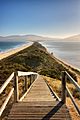
"The Neck" connects the two halves of Bruny Island and is an important breeding site for short-tailed shearwater and fairy penguins.
-
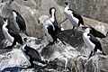
Black-faced cormorants (Phalacrocorax fuscescens), Bruny Island, Tasmania
-
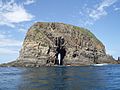
Rock formation off the coast of Bruny Island


Images for kids
-
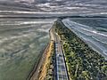
Aerial perspective of the isthmus of Bruny Island, looking north

See also
 In Spanish: Isla Bruny para niños
