
Bulwer, Queensland facts for kids
Quick facts for kids BulwerQueensland |
|||||||||||||||
|---|---|---|---|---|---|---|---|---|---|---|---|---|---|---|---|

One of the scuttled ships on the beach at Bulwer, 2011
|
|||||||||||||||

Bulwer
Location in Queensland
|
|||||||||||||||
| Population | 49 (2016 census) | ||||||||||||||
| • Density | 123/km2 (320/sq mi) | ||||||||||||||
| Postcode(s) | 4025 | ||||||||||||||
| Area | 0.4 km2 (0.2 sq mi) | ||||||||||||||
| Time zone | AEST (UTC+10:00) | ||||||||||||||
| LGA(s) | City of Brisbane | ||||||||||||||
| State electorate(s) | Redcliffe | ||||||||||||||
| Federal Division(s) | Bonner | ||||||||||||||
|
|||||||||||||||
Bulwer is a coastal town and locality at the north-western end of Moreton Island in the City of Brisbane, Queensland, Australia. In the 2016 census the locality of Bulwer had a population of 49 people.
Population
At the 2006 census, Bulwer had a population of 70.
Transport
Bulwer is accessible from Brisbane on the mainland via the Micat Barge service. It is one of the main access points for visitors to the island, 98% of which is in the Moreton Island National Park.
Facilities
Facilities at Bulwer include a helipad and first aid station as well as holiday accommodation, a general store and public phone.
Education
There are no schools in Bulwer, nor any nearby. Distance education or boarding school are options.
Images for kids
-
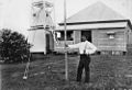
James Palmer, pilot station keeper at the pilot station house at Bulwer, 1908
-
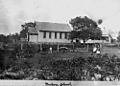
Cricket match at Bulwer State School, Queensland, 1899. Group of children playing cricket in the grounds of Bulwer State School, on Moreton Island, in 1899. The teacher's residence is next to the school.
-
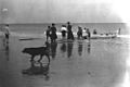
Landing a boat at Bulwer, 1906
.jpg)


