
Burleigh County, North Dakota facts for kids
Quick facts for kids
Burleigh County
|
|
|---|---|

Burleigh County Courthouse
|
|

Location within the U.S. state of North Dakota
|
|
 North Dakota's location within the U.S. |
|
| Country | |
| State | |
| Founded | 1873 |
| Named for | Walter A. Burleigh |
| Seat | Bismarck |
| Largest city | Bismarck |
| Area | |
| • Total | 1,668 sq mi (4,320 km2) |
| • Land | 1,633 sq mi (4,230 km2) |
| • Water | 36 sq mi (90 km2) 2.1% |
| Population
(2020)
|
|
| • Total | 98,458 |
| • Estimate
(2021)
|
98,933 |
| • Density | 59.028/sq mi (22.791/km2) |
| Time zone | UTC−6 (Central) |
| • Summer (DST) | UTC−5 (CDT) |
| Congressional district | At-large |
Burleigh County is a county in the U.S. state of North Dakota. As of the 2020 census, the population was 98,458, making it the second-most populous county in North Dakota. Its county seat is Bismarck, the state capital. The county was named for Dakota Territory political figure Walter A. Burleigh.
Contents
Geography
According to the U.S. Census Bureau, the county has a total area of 1,668 square miles (4,320 km2), of which 1,633 square miles (4,230 km2) is land and 36 square miles (93 km2) (2.1%) is water.
Major highways
 Interstate 94
 U.S. Highway 83
 North Dakota Route 14
 North Dakota Highway 36
 North Dakota Highway 41
 North Dakota Highway 1804
Adjacent counties
- Sheridan County (north)
- Kidder County (east)
- Emmons County (south)
- Morton County (southwest)
- Oliver County (west)
- McLean County (northwest)
National protected areas
- Canfield Lake National Wildlife Refuge
- Florence Lake National Wildlife Refuge
- Long Lake National Wildlife Refuge (part)
Demographics
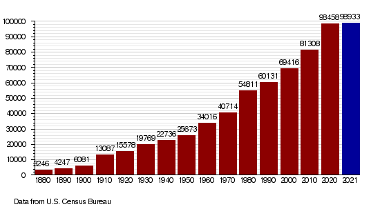
| Historical population | |||
|---|---|---|---|
| Census | Pop. | %± | |
| 1880 | 3,246 | — | |
| 1890 | 4,247 | 30.8% | |
| 1900 | 6,081 | 43.2% | |
| 1910 | 13,087 | 115.2% | |
| 1920 | 15,578 | 19.0% | |
| 1930 | 19,769 | 26.9% | |
| 1940 | 22,736 | 15.0% | |
| 1950 | 25,673 | 12.9% | |
| 1960 | 34,016 | 32.5% | |
| 1970 | 40,714 | 19.7% | |
| 1980 | 54,811 | 34.6% | |
| 1990 | 60,131 | 9.7% | |
| 2000 | 69,416 | 15.4% | |
| 2010 | 81,308 | 17.1% | |
| 2020 | 98,458 | 21.1% | |
| 2021 (est.) | 98,933 | 21.7% | |
| US Decennial Census 1790-1960 1900-1990 1990-2000 2010-2020 |
|||
As of the 2010 census, there were 81,308 people, 33,976 households, and 21,213 families in the county. The population density was 49.8 inhabitants per square mile (19.2/km2). There were 35,754 housing units at an average density of 21.9 per square mile (8.5/km2). The racial makeup of the county was 93.0% white, 4.2% American Indian, 0.6% black or African American, 0.5% Asian, 0.3% from other races, and 1.4% from two or more races. Those of Hispanic or Latino origin made up 1.2% of the population. In terms of ancestry, 61.0% were German, 21.1% were Norwegian, 8.1% were Russian, 6.8% were Irish, and 2.6% were American.
Of the 33,976 households, 29.0% had children under the age of 18 living with them, 50.2% were married couples living together, 8.7% had a female householder with no husband present, 37.6% were non-families, and 30.5% of all households were made up of individuals. The average household size was 2.31 and the average family size was 2.90. The median age was 37.3 years.
The median income for a household in the county was $53,465 and the median income for a family was $71,103. Males had a median income of $44,944 versus $31,943 for females. The per capita income for the county was $28,784. About 6.3% of families and 9.4% of the population were below the poverty line, including 11.6% of those under age 18 and 11.0% of those age 65 or over.
Population by decade
Communities
Cities
Townships
- Apple Creek
- Boyd
- Burn Creek
- Canfield
- Christiania
- Clear Lake
- Crofte
- Cromwell
- Driscoll
- Ecklund
- Estherville
- Florence Lake
- Francis
- Ghylin
- Gibbs
- Glenview
- Grass Lake
- Harriet-Lien
- Hay Creek
- Hazel Grove
- Logan
- Long Lake
- McKenzie
- Menoken
- Missouri
- Morton
- Naughton
- Painted Woods
- Richmond
- Rock Hill
- Schrunk
- Sibley Butte
- Steiber
- Sterling
- Taft
- Telfer
- Thelma
- Trygg
- Wild Rose
- Wilson
- Wing
Census-designated places
Unincorporated communities
See also
 In Spanish: Condado de Burleigh para niños
