
Burnt Corn, Alabama facts for kids
Quick facts for kids
Burnt Corn, Alabama
|
|
|---|---|

Former Lowrey's General Store and Post Office
|
|

Burnt Corn, Alabama
Location in Alabama

Burnt Corn, Alabama
Location in the United States
|
|
| Country | United States |
| State | Alabama |
| County | Monroe |
| Elevation | 427 ft (130 m) |
| Time zone | UTC-6 (CST) |
| • Summer (DST) | UTC-6 (EDT) |
| ZIP codes |
36401
|
| Area code(s) | 251 |
| GNIS feature ID | 115265 |
Burnt Corn is an unincorporated community on the boundary between Monroe County and Conecuh County in Alabama, United States. It is located near the source of Burnt Corn Creek, at the intersection of two historic trading paths. It has been noted for its unusual name.
Demographics
Burnt Corn appeared on the 1880 U.S. Census with a population of 33 residents. This was the only time it appeared on the census.
Gallery
-
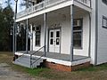
The now-vacant Lowrey's General Store and Post Office in Burnt Corn.
-
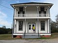
Front view of Lowrey's General Store and Post Office.
-
An out building near Lowrey's General Store.
-
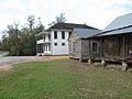
View of Lowrey's General Store and Post Office and nearby out buildings.
-
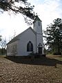
Burnt Corn, Alabama, Methodist Church.
-
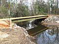
Side view of wooden bridge over Murder Creek near Burnt Corn.
-
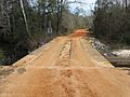
Front view of one-lane wooden bridge over Murder Creek near Burnt Corn.
-
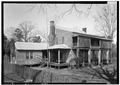
Watkins House. Recorded as part of Historic American Buildings Survey


