Butlerville, Indiana facts for kids
Quick facts for kids
Butlerville, Indiana
|
|
|---|---|
 |
|

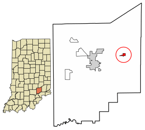
Location of Butlerville in Jennings County, Indiana
|
|
| Country | United States |
| State | Indiana |
| County | Jennings |
| Township | Campbell |
| Area | |
| • Total | 0.37 sq mi (0.97 km2) |
| • Land | 0.37 sq mi (0.97 km2) |
| • Water | 0.00 sq mi (0.00 km2) |
| Elevation | 807 ft (246 m) |
| Population
(2020)
|
|
| • Total | 300 |
| • Density | 804.29/sq mi (310.76/km2) |
| ZIP code |
47223
|
| GNIS feature ID | 431906 |
| FIPS code | 18-09622 |
Butlerville is an unincorporated community and census-designated place (CDP) in central Campbell Township, Jennings County, Indiana, United States. As of the 2010 census it had a population of 282.
Contents
History
The Butlerville post office was established in 1851. An early settler being a former resident of Butlerville, Ohio, caused the name to be selected. Butlerville was legally platted in 1853.
Hannah Milhous Nixon, mother of President Richard Nixon, was born near Butlerville.
Geography
Butlerville lies along U.S. Route 50 east-northeast of the town of Vernon, the county seat of Jennings County.
Its elevation is 807 feet (246 m), and it is located at 39°2′4″N 85°30′46″W / 39.03444°N 85.51278°W (39.0344983, -85.5127432). Although Butlerville is unincorporated, it has a post office, with the ZIP code of 47223.
Demographics
| Historical population | |||
|---|---|---|---|
| Census | Pop. | %± | |
| 2020 | 300 | — | |
| U.S. Decennial Census | |||
See also
 In Spanish: Butlerville (Indiana) para niños


