Cé (Pictish territory) facts for kids
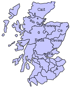
Cé was a Pictish territory recorded during the Early Medieval period and located in the area of modern-day Aberdeenshire, Scotland.
Location
The name of Cé survives in the placename of the mountain Bennachie in modern-day Aberdeenshire, which means "Mountain of the people of Cé" and suggests that the hillfort on Bennachie's Mither Tap may have been Cé's preeminent settlement. The Plain of Cé would therefore have included Garioch, Donside and the coastal plain of Aberdeenshire to the east, perhaps centred on the watershed of the River Ury.
Cé encompassed Banff, Buchan, and other areas of Aberdeenshire, such as the region now known as Mar.
After the Roman period, a number of Pictish kingdoms formed in Eastern Scotland. The kingdom of Circind, which was further divided into the kingdoms of Fotla (Atholl), Fib (Fife) and Circind (county of Angus), bordered the kingdom of Cé to the south. In the west, around modern Inverness, might have been the kingdom of Fidach. In the far north and the Northern Isles was the kingdom of Cat, which later gave the name to the county of Caithness.
By the 6th century, the Pictish people were divided into the larger kingdoms of the Northern and Southern Picts. Cé can be regarded as a frontier region between northern and southern Pictish influence.
Cé may also have included Mortlach, near modern Dufftown, which was the original seat of what became the later Diocese of Aberdeen, whose origins may lie as the episcopate of the district of Cé around 700.
Nothing is known of the political status or structure of Cé and there is no evidence that it had its own kings.
See also


