
Céret facts for kids
Quick facts for kids
Céret
|
||
|---|---|---|

The city of Céret
|
||
|
||

Céret
Location in France

Céret
Location in Occitanie
|
||
| Country | France | |
| Region | Occitanie | |
| Department | Pyrénées-Orientales | |
| Arrondissement | Céret | |
| Canton | Vallespir-Albères | |
| Intercommunality | Communauté de communes du Vallespir | |
| Area
1
|
37.86 km2 (14.62 sq mi) | |
| Population
(2014)
|
7,663 | |
| • Density | 202.40/km2 (524.22/sq mi) | |
| Demonym(s) | Cérétans | |
| Time zone | UTC+01:00 (CET) | |
| • Summer (DST) | UTC+02:00 (CEST) | |
| INSEE/Postal code |
66049 /66400
|
|
| Elevation | 107–1,440 m (351–4,724 ft) (avg. 154 m or 505 ft) |
|
| Website | Official website: http://www.mairie-ceret.fr/ | |
| 1 French Land Register data, which excludes lakes, ponds, glaciers > 1 km2 (0.386 sq mi or 247 acres) and river estuaries. | ||

Céret is a commune in the Pyrénées-Orientales department in southern France. It was the capital of the historic Catalan comarque of Vallespir.
It is a subprefecture in the department and the capital of the Céret arrondissement.
Contents
Name of the city
The name Céret comes from the Catalan name for the town: Ceret.
Former known names of Céret are, in order of appearance, vicus Sirisidum in 814, vico Cereto in 866, villa Cerseto in 915, vigo Ceresido in 930, also Cered and Ceriteto in the 10th century, Ceret, Cericeto in the XIth and XIIth centuries, Cirset around 1070, Cersed (one of the most common forms) in 1130 and Cerset in 1138, and from the XIIIth to the XVth centuries Cereto, Ceret, Seret and Saret. Ceret becomes the most common form around the XVIth century.
Geography
Céret lies in the foothills of the Pyrénées mountains, in southern France. It is in the valley of the Tech river.
It has an area of 37.86 km2 (14.62 sq mi) and its average altitude is 154 m (505 ft); at the city hall, the altitude is 160 m (520 ft). The lowest point (107 m [351 ft]) of the commune is on the Tech river and the highest is on the Roc de Frausa (1,440 m [4,720 ft]).
 |
The commune is at 35 km (22 mi) from Perpignan, 200 km (124 mi) from Montpellier and at 250 km (155 mi) from Toulouse. It is surrounded by the communes Vivès, Saint-Jean-Pla-de-Corts, Maureillas-las-Illas, Reynès, Oms.
 |
Oms | Vivès | Saint-Jean-Pla-de-Corts | |
| Reynès | Maureillas-las-Illas | |||
| Maçanet de Cabrenys (Spain) |
Climate
The climate of Céret, in the Köppen climate classification, is Cfb - Oceanic climate with template summers.
Population
The inhabitants of Céret are known, in French, as cerétans (women: céretanes).
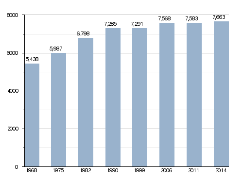
With a population in 2014 of 7,663, Céret has a population density of 202 inhabitants/km2.
Evolution of the population in Céret
Administration
Céret is a subprefecture of the Pyrénées-Orientales department since 1790. It is also the capital of the arrondissement of Céret and the administrative centre (French: chef-lieu) of the canton Vallespir-Albères with 13 communes and 29,894 inhabitants in 2014.
It is part of the intercommunality Vallespir (French: Communauté de communes du Vallespir).
Mayors
| Mayor | Term start | Term end |
|---|---|---|
| Onuphre Tarris | 1919 | 1940 |
| Henri Rey | 1940 | 1941 |
| Henri Mouchard | 1941 | 1943 |
| Jean Maler | 1943 | 1944 |
| Jacques Souquet | 1944 | 1945 |
| Gaston Cardonne | 1945 | 1947 |
| Henri Guitard | 1947 | 1963 |
| Marcel Parayre | 1963 | 1964 |
| Michel Sageloly Sr. | 1964 | 1983 |
| Henri Sicre | 1983 | 1995 |
| Michel Sageloly Jr. | 1995 | 1996 |
| Henri Sicre | 1996 | 2001 |
| Alain Torrent | 2001 | 2020 |
| Michel Coste | 2020 |
Twin cities
Céret is a twin town of:
Economy
The region around Céret is a major fruit producer, in particular famed for its cherries. The first of the season's pick are, by local tradition, sent to France's President. Céret has a cherry festival each year. The cherry season is during the end of April and May.
Sites of interest
Céret is famous for its Musée d'Art Moderne (Museum of Modern Art), which has numerous Picasso paintings, sculptures and ceramics. The museum also features paintings by Chagall, Matisse, Herbin, Soutine, lots of Fauves and a few Impressionists.
The Museum of Musical Instruments opened in May 2013 and has a unique collection of instruments and musical scores.
The Pont du Diable (Devil's Bridge) is a single arch stone bridge built between 1321 and 1341.
Gallery

-
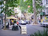
Céret, main street
-
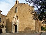
Saint Peter church, Céret
-
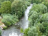
Le Tech river, Céret
-
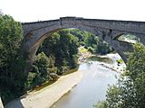
Le Pont du Diable (The Devil's bridge), Céret


Related pages
Images for kids
-
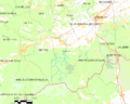
Map of Céret and its surrounding communes
-
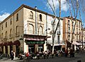
The Grand Café today

See also
 In Spanish: Céret para niños
