
Caguas, Puerto Rico facts for kids
Quick facts for kids
Caguas
Municipio Autónomo de Caguas
|
|||
|---|---|---|---|
|
City and Municipality
|
|||

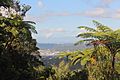
View of Caguas and the valley from the north in Altos de San Luis.
|
|||
|
|||
| Nicknames:
"La Ciudad del Turabo" (Turabo Valley), "La Ciudad Criolla" (Creole City), "La Cuna de los Trovadores" (Cradle of Trovadores)
|
|||
| Anthem: "Centro y Corazón de Puerto Rico" | |||

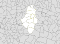
Map of Puerto Rico highlighting Caguas Municipality
|
|||
| Commonwealth | |||
| Founded | January 1, 1775 | ||
| Barrios | |||
| Area | |||
| • Total | 59.07 sq mi (153.00 km2) | ||
| • Land | 58.68 sq mi (151.97 km2) | ||
| • Water | 0.40 sq mi (1.03 km2) | ||
| Elevation | 211.0 ft (64.3 m) | ||
| Population
(2020)
|
|||
| • Total | 127,244 | ||
| • Density | 2,153.99/sq mi (831.660/km2) | ||
| Demonym(s) | Cagüeños caguenses | ||
| Ethnicity | |||
| • White | 84.5% | ||
| • Black | 7.8% | ||
| • American Indian/AN | 0.6% | ||
| • Asian | 0.3% | ||
| • Native Hawaiian/PI | 0.1% | ||
| Time zone | UTC-4 (AST) | ||
| ZIP Codes |
00725, 00726, 00727
|
||
| Area code(s) | 787/939 | ||
| Major routes | |||
| Website | caguas.gov.pr | ||


Caguas is a city and municipality of Puerto Rico located in the Central Mountain Range of Puerto Rico, south of San Juan and Trujillo Alto, west of Gurabo and San Lorenzo, and east of Aguas Buenas, Cidra, and Cayey. Caguas was founded in 1775. The municipality had a population of 127,244 at the 2020 census.
Caguas is located 20 miles (32 km) from San Juan. It is located in the Valle de Caguas or Caguas Valley (also known as Valle del Turabo or the Turabo Valley), at the eastern ranges of the Central Mountain Range. It is known as La Ciudad Criolla (Criollo City), Valle del Turabo (the Turabo Valley) and La Cuna de los Trovadores (The Cradle of the Trovadores). Its name originates from the Taíno cacique Caguax, who was a regional chief. Caguas is a principal city of both the San Juan-Caguas-Guaynabo Metropolitan Statistical Area and the San Juan-Caguas-Fajardo Combined Statistical Area.
Contents
History
Caguas was founded on January 1, 1775 as San Sebastián del Piñal de Caguax, later shortened and modernized to its current form. Caguax was a local Taíno chief and early convert to Christianity. Caguas' construction was finished in 1779, in 1820 it was declared a valley and in 1894 it became a city.
In 2002, Caguas was the site of the 2002 USAF Hercules air disaster.
Geography
Caguas is located in the largest valley in Puerto Rico, the "Valle de Caguas" which it shares with Gurabo and part of Aguas Buenas. It is located approximately 30 minutes from the coastline both on the east (Humacao) and the north (San Juan), and is divided from the Gurabo portion of the valley by the river of the same name. It is east of Aguas Buenas and Cidra, north of Cayey, south of San Juan, and west of Gurabo and Trujillo Alto. It also shares borders with Guayama and Patillas via a five-point border, with Cayey and San Lorenzo. At this point there are two tall antennas which provide signal to Puerto Rico's principal TV stations such as WKAQ-TV and WAPA-TV. No road passes exactly at this point, and it can be approached nearby through Puerto Rico Highway 184. Being a valley, Caguas has the distinction of being relatively flat except near the borders with all the mentioned municipalities except Gurabo.
Water features
- The Río Grande de Loíza divides this municipality from Gurabo.
- Other Rivers: Río Turabo, Río Caguitas, Río Cañaboncito, Río Bairoa and Río Cañas.
Climate
The climate is classified as a Tropical monsoon climate, meaning the daily mean temperature from month to month is never less than 64.4 °F (18 °C), and there is a distinct wet and dry season. Rainfall is common in relative abundance throughout most of the year, although there is less rain than in the eastern coastal valleys. The land, however, is fertile and deep.
| Month | Jan | Feb | Mar | Apr | May | Jun | Jul | Aug | Sep | Oct | Nov | Dec | Year |
|---|---|---|---|---|---|---|---|---|---|---|---|---|---|
| Record high °C (°F) | 33 (92) |
34 (93) |
35 (95) |
35 (95) |
36 (97) |
37 (99) |
37 (99) |
37 (98) |
38 (101) |
37 (99) |
35 (95) |
35 (95) |
38 (101) |
| Average high °C (°F) | 26.3 (79.3) |
27.2 (80.9) |
30.2 (86.4) |
31.2 (88.1) |
31.9 (89.4) |
32.5 (90.5) |
32.6 (90.7) |
32.8 (91.1) |
32.8 (91.0) |
32.2 (90.0) |
30.8 (87.4) |
29.4 (84.9) |
30.8 (87.5) |
| Daily mean °C (°F) | 21.6 (70.9) |
21.7 (71.1) |
23.5 (74.3) |
25.1 (77.1) |
26.4 (79.6) |
27.4 (81.4) |
28.2 (82.7) |
28.1 (82.5) |
28.2 (82.8) |
27.6 (81.6) |
25.6 (78.1) |
24.1 (75.4) |
25.6 (78.1) |
| Average low °C (°F) | 16.9 (62.5) |
16.2 (61.1) |
16.8 (62.3) |
18.9 (66.0) |
21.0 (69.8) |
22.4 (72.4) |
23.7 (74.7) |
23.3 (74.0) |
23.7 (74.7) |
22.9 (73.2) |
20.4 (68.7) |
18.8 (65.8) |
20.4 (68.8) |
| Record low °C (°F) | 10 (50) |
10 (50) |
9 (49) |
13 (56) |
17 (62) |
18 (65) |
19 (66) |
19 (67) |
19 (66) |
18 (64) |
15 (59) |
14 (57) |
9 (49) |
| Average rainfall mm (inches) | 77 (3.05) |
68 (2.68) |
35 (1.39) |
110 (4.32) |
266 (10.46) |
107 (4.22) |
88 (3.46) |
128 (5.03) |
247 (9.74) |
181 (7.12) |
200 (7.87) |
107 (4.20) |
1,512 (59.52) |
| Average snowfall cm (inches) | 0 (0) |
0 (0) |
0 (0) |
0 (0) |
0 (0) |
0 (0) |
0 (0) |
0 (0) |
0 (0) |
0 (0) |
0 (0) |
0 (0) |
0 (0) |
| Average rainy days (≥ 0.10) | 9 | 7 | 6 | 12 | 18 | 11 | 8 | 10 | 14 | 10 | 18 | 9 | 100 |
| Average snowy days (≥ 1.00) | 0 | 0 | 0 | 0 | 0 | 0 | 0 | 0 | 0 | 0 | 0 | 0 | 0 |
| Source: Southeast Regional Climate Center | |||||||||||||
Cityscape
Barrios
- Caguas Pueblo
- Bairoa
- Beatriz
- Borinquen
- Cañabón
- Cañaboncito
- Rio Cañas
- San Antonio
- San Salvador
- Tomás de Castro
- Turabo
- Villa del Rey
Tourism


Landmarks and places of interest
- Caguas Historical Museum
- Caguas Cathedral
- Coquí Villa
- Hacienda Catalina Ruins
- Hacienda Cofresí
- Hacienda Country Club
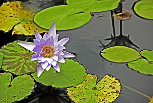
- Jardín Botánico y Cultural William Miranda Marín
- La Casa de Ajedrez (The House of Chess)
- Tobacco Museum
- Catedral Dulce Nombre De Jesus (In town plaza founded in 1729 and constructed in 1774).
Culture
Festivals and events
- Rosario Cantado a los Reyes – 4 January
- Criolla Beatriz – February
- Criolla Borinquen Fair – March
- Criolla Cañabón Fair – April
- Felipe "La Voz Rodríguez' Birthday – 8 May
- Al Fresco – Every last Friday of each month
Sports
The Criollos de Caguas baseball team is considered one of the greatest of all-time in all of Latin America, having won 16 national Puerto Rico titles and 3 Caribbean World Series titles The team is a member of the Liga de Béisbol Profesional de Puerto Rico (LBPPR). Three of the first five Puerto Ricans that played Major League Baseball in the U.S., at one point in their careers played for the Criollos de Caguas (Luis Rodríguez Olmo, Victor Pellot Power, Roberto Clemente).
The Criollos de Caguas basketball team, founded in 1968 by Dr. Héctor "Tato" Dávila and Lcdo. Libertario Pérez Rodríguez, hasn't enjoyed as much success as their baseball counterparts. However in the early 2000s, they showed a lot of progress by reaching the national playoffs various times. The team is a member of the BSN. In 2006, the team won its first BSN national basketball championship, defeating Flor Melendez and his Santurce Crabbers in five games.
Caguas is home to the Bairoa Gym, one of the most important boxing gyms in all Puerto Rico and a place where many visiting champions have trained at; such as boxing Welterweight Champion Miguel Cotto, his brother Jose Miguel, Alberto Mercado, Juan Carazo, Alfredo Escalera and others.
The Criollas de Caguas women's volleyball team has won 9 national Puerto Rico titles and has made it to the finals more than 15 times. The team is a member of the Liga de Voleibol Superior Femenino (LVSF).
Demographics
| Historical population | |||
|---|---|---|---|
| Census | Pop. | %± | |
| 1900 | 19,857 | — | |
| 1910 | 27,160 | 36.8% | |
| 1920 | 35,920 | 32.3% | |
| 1930 | 47,728 | 32.9% | |
| 1940 | 53,356 | 11.8% | |
| 1950 | 60,132 | 12.7% | |
| 1960 | 65,098 | 8.3% | |
| 1970 | 95,661 | 46.9% | |
| 1980 | 117,959 | 23.3% | |
| 1990 | 133,447 | 13.1% | |
| 2000 | 140,502 | 5.3% | |
| 2010 | 142,893 | 1.7% | |
| 2020 | 127,244 | −11.0% | |
| U.S. Decennial Census 1899 (shown as 1900) 1910-1930 1930-1950 1960-2000 2010 2020 |
|||
In 1899, the United States conducted its first census of Puerto Rico finding that the population of Caguas was 19,857.
In 2020, Caguas had a population of 127,244 compared to 142,893 in 2010. This shows an 11% decrease in the population in the municipality. The population density in 2020 was 2,200 people per square mile (830/km2). Hispanic or Latino of any race constitute 98.4% of the population of the municipality. There are also communities of Dominicans, Cubans and Colombians.
Transportation

Public transportation in Caguas, as in most of Puerto Rico, is limited to small "guaguas públicas" (Mini Bus). There is inexpensive but slow service to and from San Juan and Rio Piedras. Several buses and public taxi services serve the town to a limited degree. In 2019, 91.55% of the population relied on their own cars or carpool services to commute.
A "light interurban rail" system connecting Caguas to San Juan was in the planning stages and discarded due to lack of funding.
Caguas is served by one freeway, one tolled expressway and one main divided highway. Puerto Rico Highway 30 connects Caguas to the eastern part of the island. There is no freeway/expressway to the west, due mainly to the fact that there is no sufficient population west of Caguas to develop a new freeway or expressway; good access to the municipalities of Cidra (southwest) and Aguas Buenas (northwest) are possible via PR-172 and PR-156, respectively. Puerto Rico Highway 52 connects Caguas to the north (San Juan) and south (Cayey, Ponce). Puerto Rico Highway 1 is an alternate route to San Juan and Guaynabo with two lanes per direction; in south Caguas it becomes rural near Borinquen, therefore the only good access to Cayey is the expressway (PR-52) and a $1.00 toll has to be paid (only in the south direction). The only municipality bordering Caguas with a poor-access road is San Lorenzo, via PR-183; but good access to San Lorenzo is possible by entering Gurabo via PR-30, and then taking PR-203 south. Luis Muñoz Marín International Airport is about 35 minutes away by car.
There are 86 bridges in Caguas.
Sister cities

 Southbridge, Massachusetts, United States
Economy
In September 2005, city mayor William Miranda Marín levied the first municipal tax in Puerto Rico via city ordinance. Area merchants now charge a one cent tax for every dollar spent at all retail businesses. The tax has become known around the island as the "Willie Tax." It resulted in an estimated $500,000 monthly income for the city. However, the municipal tax was increased to 1.5% after the establishment of the 5.5% state tax, for a total of 7%, and the tax was declared illegal by the Puerto Rico's Supreme Court.
In 2006, Miranda Marín began calling Caguas "El Nuevo País de Caguas" ("The New Country of Caguas").
Agriculture
During the early part of the 20th century, Caguas hosted one of Puerto Rico's most important sugar manufacturers, which gave employment to thousands of Cagüeños.
Business
Numerous businesses and important buildings have opened in Caguas since the 1970s, including the imposing 23 story apartment building Caguas Tower, its adjacent competitors Bonneville Apartments, and the 10 floor Menonita Hospital. There are also several shopping centers:
- Plaza del Carmen Mall
- Plaza Centro Mall
- Las Catalinas Mall
- Los Prados Mall
- Bairoa Shopping Center
- Villa Blanca Mall
- Angora Shopping Center
- Plaza Degetau
- Plaza Caguitas
- Del Rio Shopping Center
- Metro Plaza (Caguas, Puerto Rico)
Education
High schools
- Elohim Christian Academy
- New Generation Christian Academy (formerly CLA)
- Caguas Military Academy
- Colegio Bautista
- Colegio Católico San Juan Apóstol
- Academia Cristo de los Milagros
- Dr. Juan José Osuna High school
- José Gautier Benítez High school
- Escuela Libre de Música - Antonio S. Paoli
- Manuela Toro Morice High School
- Republic of Costa Rica Vocacional High School of Caguas
- Eloisa Pascual "Bairoa III" High School
- Rio Cañas High School
- Santa Rosa Superior School
- Thomas Alva Edison School
- Colegio San José Superior
- Escuela Secundaria Especializada en Ciencias, Matemáticas y Tecnología (CIMATEC)
- Caguas Private School (CPS)
Higher education
- San Juan Bautista School of Medicine
- Huertas Junior College
- Instituto EDIC
- Columbia College
- Turabo University at Gurabo (Gurabo, Puerto Rico)
Images for kids
-
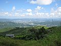
Caguas from the Sierra de Cayey.
-
View of the Caguas Valley from Cerro Las Piñas in Beatriz, Cayey.
-
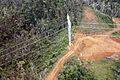
Restoring the electrical grid in Caguas, post Hurricane Maria.
-
Subdivisions of Caguas.
-
Museo de Arte de Caguas
-
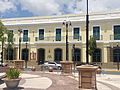
The José Ignacio Quintón Center for Criollo Music, located at the corner of Calle Ruiz Belvis and Calle Intendente Ramírez in Caguas, Puerto Rico. The center occupies the historic First Baptist Church of Caguas (built 1907–1909), and is listed on the U.S. National Register of Historic Places.
-
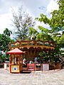
Carousel in Plaza de Caguas
-
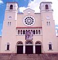
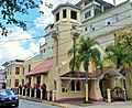
Caguas cathedral 'Dulce Nombre de Jesús' founded in 1729. On the facade hangs an image of native son Blessed Carlos Manuel Rodríguez, whose body rests in the cathedral.
-
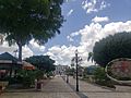
Main square for recreation, Plaza de Recreo Santiago R. Palmer in Caguas barrio-pueblo
-
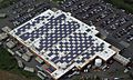
The Walmart in Caguas, Puerto Rico is one of five Walmart facilities on the island equipped with solar panels.


See also
 In Spanish: Caguas para niños
