
Caibarién facts for kids
Quick facts for kids
Caibarién
|
||
|---|---|---|

The Glorieta of Caibarién
|
||
|
||
| Nickname(s):
La Villa Blanca (The White Town)
|
||
.png)
Caibarién municipality (red) within
Villa Clara Province (yellow) and Cuba |
||
| Country | Cuba | |
| Province | Villa Clara | |
| Founded | 1832 | |
| Established | 1873 (Village) | |
| Municipality | 1879 | |
| Area | ||
| • Total | 212 km2 (82 sq mi) | |
| Elevation | 5 m (16 ft) | |
| Population
(2009)
|
||
| • Total | 37,902 | |
| • Density | 88.9/km2 (230/sq mi) | |
| Time zone | UTC-5 (EST) | |
| Area code(s) | +53-42 | |

Caibarién is a municipality city in the Villa Clara province of Cuba.
Caibarién is known as "La Villa Blanca" (lit. The White Town) for its sands and beaches. They are famous for their "Parrandas" (Carnivals) along with Remedios (the neighboring town located 7 kilometres (4.3 mi) west) and Camajuani.
Contents
History
The town was founded on October 26, 1832, from a map designed by Estratón Bauza. For his constant concern and tenacity in their efforts, and because he offered some of his lands and also economic concessions to the founding of the town Don Narciso de Justa is considered the founder of Caibarién. On 1834 it was named Colonia de Vives, but in 1837 the original name (Caibarién) was restored. On September 19, 1873, it was awarded the title village.
In 1878 the town already had stores, churches, schools and newspapers. Founded in Caibarién on October 25 was the committee of the Cuban Liberal Party, and elections were prepared between the Liberal Party and the Constitutional Union.
On January 1, 1879, Caibarién emerged as an independent municipality of Remedios and the first city council was established with Don Hipólito Escobar Martelo from the Liberal Party as its first Mayor. In 1891, Laureano López Cosío was chosen as Mayor.
In the second half of 1893, political turmoil began to increase, shedding elements from the Conservative Union to form a third political party called Reform. This year the mayor Cosío died and Damián Judez Celaya was elected. On January 18, 1895, Judez died and was succeeded by the Spanish merchant Antonio Imaz Llaguno.
Before the independence war of 1895 the village had achieved steady progress, showing an economic power that was a real surprise at the time.
The area was the scene of actions during the independence wars of the nineteenth century like the uprising of Carlos Roloff.
Geography
The city is situated on the north coast of Cuba, bordering the Bay of Buena Vista (Bahía de Buena Vista) of the Atlantic Ocean. It lies at the eastern extremity of the Villa Clara Province, close to the border with Sancti Spíritus Province. The town is served by the Caibarién Airport (IATA: -, ICAO: MUCB).
The municipality is divided into the barrios of Primero, Segundo, Tercero, Cuarto and Quinto.
Cayo Conuco
Cayo Conuco is a tiny island located 7 kilometres (4 miles) from Caibarién, which is joined to the mainland by a stone causeway. It was recently covered only by thin, dry pasture, however native plant species have resumed their original place. In 1948, the Asociación de Scouts de Cuba held its second national Jamboree in Cayo Conuco.
Economy and tourism
Caibarién once served as a shipping point for agricultural commodities, such as sugarcane, tobacco, and fruit. It also served as a sponge-fishing center. Its hotels are now destroyed by lack of care, and most concrete houses are crumbling onto its streets. The piers that once served as shipping points for agricultural commodities have fallen into the bay. The two sugar mills that used to send their sugar exports through the harbor are now closed and crumbling. The major sugar mill (Reforma) is now a museum for tourists.
The Parrandas carnivals take place twice a year in August–September and mid-December. They last usually for about two weeks at a time.
The main center for tourists in Caibarién is "Los Cayos" (The keys) with such cays as Cayo Santa María, Cayo Fragoso, Cayo Las Brujas, etc. New Cuban reforms now allow Cuban citizens to enter the resorts and beaches that were once exclusive to tourists.
Demographics
In 2004, the municipality of Caibarién had a population of 38,064. With a total area of 212 km2 (82 sq mi), it has a population density of 179.5/km2 (465/sq mi).
Twin towns/Sister cities
Notable people
Gallery
-
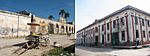
Less than a century ago one of the biggest and busiest port cities in Cuba, but today the still standing colonial storehouses are empty and collapsing owing to lack of restoration and use.
-
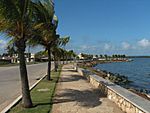
The newly made sea walk. Tourism in the northern cays of Caibarién's waters have infused a little money for public works in the city, still; most of the historic buildings are left aside until they collapse.
-
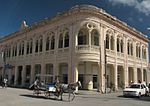
Former lyceum today holds shops and Caibarién's local history museum.


See also
 In Spanish: Caibarién para niños
- Cayo Fragoso Lighthouse
- Cayo Santa María Lighthouse
- Municipalities of Cuba
- List of cities in Cuba
