
Cairo, Georgia facts for kids
Quick facts for kids
Cairo, Georgia
|
|
|---|---|

Cairo City Hall
|
|
| Nicknames:
"Georgia's Hospitality City", and "The Syrup City"
|
|

Location in Grady County and the state of Georgia
|
|
| Country | United States |
| State | Georgia |
| County | Grady |
| Area | |
| • Total | 9.95 sq mi (25.77 km2) |
| • Land | 9.81 sq mi (25.42 km2) |
| • Water | 0.14 sq mi (0.35 km2) |
| Elevation | 243 ft (74 m) |
| Population
(2020)
|
|
| • Total | 10,179 |
| • Density | 1,037.19/sq mi (400.44/km2) |
| Time zone | UTC-5 (Eastern (EST)) |
| • Summer (DST) | UTC-4 (EDT) |
| ZIP codes |
39827, 39828
|
| Area code(s) | 229 Exchanges: 377,378 |
| FIPS code | 13-12400 |
| GNIS feature ID | 0354934 |
Cairo is a city in Grady County, Georgia, United States. As of the 2020 census, the city had a population of 10,179. The city is the county seat of Grady County.
Contents
History
Cairo was founded in 1835. It was incorporated as a town in 1870 and as a city in 1906. In 1905, Cairo was designated seat of the newly formed Grady County. The city was named after Cairo, the capital of Egypt.
Syrup City
Although Cairo is nicknamed the "Syrup City", it has no relationship with the Karo brand of corn syrup, which is pronounced like the city's name. Rather, Cairo earned its nickname by producing cane syrup from the early 1900s through the late 1990s. Of the several companies that produced cane syrup, Roddenbery's was the best known. Roddenbery's later became better known for its pickles and the world's largest outdoor brine yard. However, the company was sold to Dean Foods in 1993 and the local factory shut down.
Reflecting its "syrup" heritage, the Cairo High School football team is nicknamed the Syrupmakers, and the school mascot is the agriculturally based sugar cane farmer/syrupmaker similar to the Cornhusker and Boilermaker. According to local tradition, this began during a rainy football game, when the players wore donated ponchos with "Roddenbery Syrup" printed on them. The most widely accepted tradition and the one with the most supportive evidence claims that a newspaper reporter referred to the Cairo Tigers in print as "the syrupmakers from Cairo".
The school's female athletic teams are named "Syrup Maids", often shortened to "Maids", while the male athletes are often dubbed "Makers". In 1986 ESPN chose "Syrupmakers" as the No. 1 nickname for a high school sports team. In 2009, ESPN's Sports Center selected the Syrupmakers as their number one mascot in the high school heritage category.
Recreation and entertainment
Cairo is close to great hunting, fishing, and points of historical interest. The local industrial base continues to grow with manufacturing, service, and healthcare companies anchoring a strong economy.
The area is home to several local festivals, including Calvary's Mule Day, Whigham's Rattlesnake Roundup, Cairo's own Antique Car Rally, and several competitive recreational programs. The Antique Car Rally features a wide range of cars, and includes many activities: a poker run, a parade, and even a street dance. It usually takes place on the second weekend of May. Sponsored by Mr. Chick, it is an annual event that attracts many people to the southwest corner of Georgia.
Geography
Cairo is located in central Grady County at 30°53′N 84°13′W / 30.883°N 84.217°W (30.8778, -84.2089). U.S. Route 84 (38th Boulevard) passes through the northern part of the city, leading east 14 miles (23 km) to Thomasville and west 24 miles (39 km) to Bainbridge. Valdosta is 59 miles (95 km) to the east, and Dothan, Alabama, is 79 miles (127 km) to the west on US 84. Georgia State Route 93 passes through the center of Cairo as Broad Street and Fifth Street; it leads north 19 miles (31 km) to Pelham and south 12 miles (19 km) to U.S. Route 319 north of the Florida border. Tallahassee, Florida, is 33 miles (53 km) to the south.
According to the United States Census Bureau, Cairo has a total area of 9.8 square miles (25.4 km2), of which 9.7 square miles (25.1 km2) is land and 0.1 square miles (0.3 km2), or 1.38%, is water.
Climate
The climate in this area is characterized by relatively high temperatures and evenly distributed precipitation throughout the year. According to the Köppen Climate Classification system, Cairo has a humid subtropical climate, abbreviated "Cfa" on climate maps.
| Climate data for Cairo, Georgia | |||||||||||||
|---|---|---|---|---|---|---|---|---|---|---|---|---|---|
| Month | Jan | Feb | Mar | Apr | May | Jun | Jul | Aug | Sep | Oct | Nov | Dec | Year |
| Average high °F (°C) | 64 (18) |
66 (19) |
73 (23) |
80 (27) |
86 (30) |
90 (32) |
91 (33) |
91 (33) |
87 (31) |
81 (27) |
71 (22) |
65 (18) |
79 (26) |
| Average low °F (°C) | 42 (6) |
42 (6) |
48 (9) |
55 (13) |
62 (17) |
68 (20) |
70 (21) |
70 (21) |
67 (19) |
57 (14) |
46 (8) |
42 (6) |
56 (13) |
| Average precipitation inches (mm) | 3.9 (99) |
4.1 (100) |
5.3 (130) |
3.9 (99) |
3.4 (86) |
5.5 (140) |
6.4 (160) |
5.6 (140) |
4.4 (110) |
2.5 (64) |
2.6 (66) |
3.5 (89) |
51.2 (1,300) |
| Source: Weatherbase | |||||||||||||
Demographics
| Historical population | |||
|---|---|---|---|
| Census | Pop. | %± | |
| 1880 | 275 | — | |
| 1890 | 521 | 89.5% | |
| 1900 | 690 | 32.4% | |
| 1910 | 1,505 | 118.1% | |
| 1920 | 1,908 | 26.8% | |
| 1930 | 3,169 | 66.1% | |
| 1940 | 4,653 | 46.8% | |
| 1950 | 5,577 | 19.9% | |
| 1960 | 7,427 | 33.2% | |
| 1970 | 8,061 | 8.5% | |
| 1980 | 8,777 | 8.9% | |
| 1990 | 9,035 | 2.9% | |
| 2000 | 9,239 | 2.3% | |
| 2010 | 9,607 | 4.0% | |
| 2020 | 10,179 | 6.0% | |
| U.S. Decennial Census | |||
2020 census
| Race | Num. | Perc. |
|---|---|---|
| White | 3,293 | 32.35% |
| Black or African American | 4,688 | 46.06% |
| Native American | 27 | 0.27% |
| Asian | 68 | 0.67% |
| Pacific Islander | 3 | 0.03% |
| Other/Mixed | 263 | 2.58% |
| Hispanic or Latino | 1,837 | 18.05% |
As of the 2020 United States Census, there were 10,179 people, 3,567 households, and 2,169 families residing in the city.
Education
Grady County Schools serves the city. Cairo High School, located in Cairo serves as a central high school for all of Grady County. Elementary schools serving students in the city include Eastside Elementary, Northside Elementary and Southside Elementary. Washington Middle School serves Cairo residents.
A campus of the Southern Regional Technical College is located in Cairo.
Notable people
- Notable Cairo people include:
-
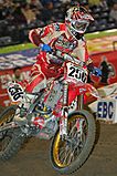
Bryan Johnson,
born 1986,
professional motocross and supercross rider. -
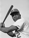
Jackie Robinson,
born 1919,
American professional baseball second baseman who became the first African American to play in Major League Baseball (MLB) in the modern era. -
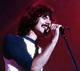
Mickey Thomas,
born 1949,
American rock singer, best known as one of the lead vocalists of Jefferson Starship and Starship.


- Teresa Edwards, former professional basketball player and an Olympic gold medalist
- Emerson Hancock, former pitcher for University of Georgia and selected to the Seattle Mariners as the 6th overall pick in the 2020 MLB Draft.
- Willie Harris, outfielder and second baseman in Major League Baseball from 2001 through 2012, member of the 2005 World Champion Chicago White Sox
- Bryan Johnson, former professional motocross racer.
- John Monds, 2010 Libertarian gubernatorial candidate for the state of Georgia
- David Ponder, former defensive tackle for the Dallas Cowboys
- Ernest Riles, shortstop and third baseman in Major League Baseball
- Jackie Robinson, Baseball Hall of Famer; first person to break the color barrier in Major League Baseball; born in Cairo
- Matthew "Mack" Robinson, Olympic silver medalist, older brother of Jackie Robinson
- Daryle Singletary, country music singer
- George Thornewell Smith, Georgia politician
- Bill Stanfill, former All-Pro National Football League defensive end
- Mickey Thomas, lead singer of Jefferson Starship
- Bobby Walden, former punter for the Pittsburgh Steelers and Minnesota Vikings
- J. J. Wilcox, safety for the New York Jets
- Arthur L. Williams Jr., founder of Primerica Financial Services
- Curley Williams, country music singer and songwriter; born near Cairo in Grady County
See also
 In Spanish: Cairo (Georgia) para niños
