
Califon, New Jersey facts for kids
Quick facts for kids
Califon, New Jersey
|
|
|---|---|
|
Borough
|
|
| Borough of Califon | |

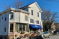
Victorian house on Main Street
|
|

Map of Califon in Hunterdon County. Inset: Location of Hunterdon County highlighted in the State of New Jersey.
|
|

Census Bureau map of Califon, New Jersey
|
|

Califon, New Jersey
Location in Hunterdon County, New Jersey

Califon, New Jersey
Location in New Jersey

Califon, New Jersey
Location in the United States
|
|
| Country | |
| State | |
| County | |
| Incorporated | April 2, 1918 |
| Named for | California |
| Government | |
| • Type | Borough |
| • Body | Borough Council |
| Area | |
| • Total | 0.98 sq mi (2.54 km2) |
| • Land | 0.96 sq mi (2.48 km2) |
| • Water | 0.02 sq mi (0.05 km2) 2.04% |
| Area rank | 502nd of 565 in state 23rd of 26 in county |
| Elevation | 479 ft (146 m) |
| Population | |
| • Total | 1,076 |
| • Estimate
(2019)
|
1,046 |
| • Rank | 531st of 566 in state 24th of 26 in county |
| • Density | 1,133.3/sq mi (437.6/km2) |
| • Density rank | 363rd of 566 in state 6th of 26 in county |
| Time zone | UTC−05:00 (Eastern (EST)) |
| • Summer (DST) | UTC−04:00 (Eastern (EDT)) |
| ZIP Code |
07830
|
| Area code(s) | 908 Exchange: 832 |
| FIPS code | 3401909280 |
| GNIS feature ID | 885176 |
Califon is a borough in Hunterdon County, New Jersey, United States. As of the 2010 United States Census, the borough's population was 1,076, reflecting an increase of 21 (+2.0%) from the 1,055 counted in the 2000 Census, which had in turn declined by 18 (-1.7%) from the 1,073 counted in the 1990 Census.
The town was to originally have been called California, but the name was shortened to Califon in order to fit on the welcome sign. Alternatively, the name was related to a bright yellow cattle feed sold during the Gold Rush.
Contents
History
Califon was a station on the High Bridge Branch of the Central Railroad of New Jersey. The rail line was abandoned in 1976 and now serves as a Hunterdon County-administered rail trail called Columbia Trail, which runs south to High Bridge and north to points in Morris County.
Though the mills were present in the area of Califon for some time prior to its incorporation as a town, it was quite a while before growth became evident in the mid-nineteenth century. It was first called California, from Jacob Neighbor's enthusiasm in the milling business about the time the California Gold Rush broke out. The Borough was incorporated by an act of the New Jersey Legislature from portions of both Lebanon and Tewksbury Townships on April 2, 1918.
Local legend has it that California became a regular stop for weekend excursion trains through the countryside. When riders bought their tickets they were issued a voucher good for an ice cream; the train would stop so tourists could wander around and cash in their ice cream coupons. Anxious to exploit this source of outside revenue, residents petitioned the railroad to let them build a real station, which they did as a community project. Citing the local account again, two sign painters who came to letter the sign rode the train from Dunellen, but the background paint wasn't dry when they arrived. They sat and drank at the hotel, which later burned down. By the time the sign was ready for their artistic touch, the local tale says, "Califon" was as close to California as the inebriated painters could manage.
Califon is situated just north of the Ken Lockwood Gorge on the South Branch of the Raritan River; this pristine stretch of clear water and forest is a well-known treasure for New Jersey trout fishermen.
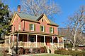
The Califon Historic District is a 164-acre (66 ha) historic district that was listed on the National Register of Historic Places in 1976. It included 154 contributing buildings, three contributing structures, and one contributing site, created through the efforts of the Califon Historical Society. Califon is a Victorian-style enclave where the houses are marked with the names of the builders and their dates of establishment rather than with street numbers.
The center of Califon is the historic iron bridge spanning the South Branch of the Raritan River, which divides the borough. Recently the State of New Jersey announced that the bridge would be replaced because a loaded school bus represented more weight than the aging bridge could safely carry. Incensed citizens objected, protective of the landmark, and found a colorful but simple solution; the school bus stops at one end of the bridge unloading the students, who then walk across to the other side. Then the empty bus, within imposed weight limits, drives across and the students get back on the bus to continue their ride. Thus the bridge was saved. (Account featured on Califon website).
Califon became a regional household name when frequently mentioned by Merv Griffin on his TV show during the 1970s. He and his wife Juliette owned a home in nearby Lebanon Township, which had a Califon mailing address, and, while they were married, they were often seen visiting the village in a fringed-top Bermuda-style resort cart. Califon Productions created all of his television ventures.
The Hoffmans were a family of German farmers who to this day are remembered by the bridge and section south of Califon known as Hoffman's Crossing. Thomas B. Hoffman farmed land that lies just south of Califon Bridge, along present day Route 513.
Geography
According to the United States Census Bureau, the borough had a total area of 0.972 square miles (2.518 km2), including 0.949 square miles (2.459 km2) of land and 0.023 square miles (0.059 km2) of water (2.36%).
Califon borders the Hunterdon County municipalities of Lebanon Township and Tewksbury Township.
Lower Valley is an unincorporated community located along the border of Califon and Lebanon Township.
Demographics
| Historical population | |||
|---|---|---|---|
| Census | Pop. | %± | |
| 1920 | 513 | — | |
| 1930 | 534 | 4.1% | |
| 1940 | 572 | 7.1% | |
| 1950 | 623 | 8.9% | |
| 1960 | 777 | 24.7% | |
| 1970 | 970 | 24.8% | |
| 1980 | 1,023 | 5.5% | |
| 1990 | 1,073 | 4.9% | |
| 2000 | 1,055 | −1.7% | |
| 2010 | 1,076 | 2.0% | |
| 2019 (est.) | 1,046 | −2.8% | |
| Population sources: 1920 1920-1930 1930-1990 2000 2010 |
|||
Census 2010
As of the census of 2010, there were 1,076 people, 394 households, and 309 families residing in the borough. The population density was 1,133.3 per square mile (437.6/km2). There were 419 housing units at an average density of 441.3 per square mile (170.4/km2)*. The racial makeup of the borough was 96.10% (1,034) White, 0.28% (3) Black or African American, 0.09% (1) Native American, 0.84% (9) Asian, 0.00% (0) Pacific Islander, 0.09% (1) from other races, and 2.60% (28) from two or more races. [[Hispanic (U.S. Census)|Hispanic or Latino of any race were 1.30% (14) of the population.
There were 394 households out of which 40.1% had children under the age of 18 living with them, 67.8% were married couples living together, 7.6% had a female householder with no husband present, and 21.6% were non-families. 17.8% of all households were made up of individuals, and 5.6% had someone living alone who was 65 years of age or older. The average household size was 2.73 and the average family size was 3.14.
In the borough, the population was spread out with 28.2% under the age of 18, 4.8% from 18 to 24, 22.6% from 25 to 44, 34.9% from 45 to 64, and 9.6% who were 65 years of age or older. The median age was 41.9 years. For every 100 females there were 93.5 males. For every 100 females ages 18 and old there were 88.5 males.
The Census Bureau's 2006-2010 American Community Survey showed that (in 2010 inflation-adjusted dollars) median household income was $108,375 (with a margin of error of +/- $9,026) and the median family income was $110,365 (+/- $5,782). Males had a median income of $95,536 (+/- $13,555) versus $73,958 (+/- $14,845) for females. The per capita income for the borough was $42,975 (+/- $5,250). About 1.7% of families and 2.4% of the population were below the poverty line, including 0.8% of those under age 18 and none of those age 65 or over.
Transportation
_just_east_of_Hunterdon_County_Route_513_(High_Bridge-Califon_Road)_in_Califon,_Hunterdon_County,_New_Jersey.jpg)
As of May 2010[update], the borough had a total of 11.50 miles (18.51 km) of roadways, of which 9.50 miles (15.29 km) were maintained by the municipality and 2.00 miles (3.22 km) by Hunterdon County.
County Routes 512 and 513 are the most prominent roads passing through Califon.
Education
The Califon School District serves students in public school for pre-kindergarten through eighth grade at Califon Public School. As of the 2017–18 school year, the district, comprised of one school, had an enrollment of 90 students and 16.4 classroom teachers (on an FTE basis), for a student–teacher ratio of 5.5:1. In the 2016–17 school year, Califon had the seventh-smallest enrollment of any school district in the state.
Public school students in ninth through twelfth grades attend Voorhees High School, which also serves students from Glen Gardner, Hampton, High Bridge, Lebanon Township and Tewksbury Township. As of the 2017–18 school year, the high school had an enrollment of 1,023 students and 86.1 classroom teachers (on an FTE basis), for a student–teacher ratio of 11.9:1. The school is part of the North Hunterdon-Voorhees Regional High School District, which also includes students from Bethlehem Township, Clinton Town, Clinton Township, Franklin Township, Lebanon Borough and Union Township who attend North Hunterdon High School in Annandale.
Eighth grade students from all of Hunterdon County are eligible to apply to attend the high school programs offered by the Hunterdon County Vocational School District, a county-wide vocational school district that offers career and technical education at its campuses in Raritan Township and at programs sited at local high schools, with no tuition charged to students for attendance.
Notable people
People who were born in, residents of, or otherwise closely associated with Califon include:
- Thomas W. Greelish (1939–1991), United States Attorney for the District of New Jersey from 1985 to 1987. Greelish moved to Califon with his family when he was seven years old.
- Merv Griffin (1925–2007), television producer, once owned a farm a few miles outside of Califon. When he created the game show Wheel of Fortune, he gave a nod to Califon when naming the show's production company. To this day, Califon Productions, Inc. is the copyright holder for all episodes of Wheel of Fortune to date, although the show is owned by Sony Pictures Television.
- Francis Burton Harrison (1873–1957), member of the United States House of Representatives and Governor-General of the Philippines under Woodrow Wilson who retired to Califon a few months before his death in 1957.
- Teddy Schneider (born 1988), soccer player for the New York Red Bulls.
Images for kids
-
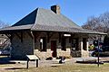
Califon Station
-
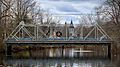
Califon Main Street Bridge
-
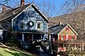
Victorian houses on Main Street
-
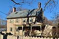
Joseph Tiger House on Mill Street
-
Former Beatty's Store on Main Street
-
1 First Street
-
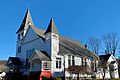
United Methodist Church on River Road
-
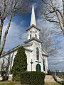
Lower Valley Presbyterian Church


See also
 In Spanish: Califon para niños
