
California wildfires of October 2007 facts for kids
Quick facts for kids October 2007 California wildfires |
|
|---|---|

NASA satellite photo (provided by NSPO, Taiwan National Space Organization) from October 22, 2007, showing the active fire zones and smoke plumes.
|
|
| Location | Southern California |
| Statistics | |
| Total fires | 30 |
| Cost | At least $2.393 billion (2007 USD) |
| Date(s) | October 20, 2007 – November 13, 2007 |
| Burned area | 972,147 acres (3,900 km2) |
| Cause | Human; downed power lines; heat; vehicle fires, etc. |
| Land use | Mixed, residential, and wildlands |
| Buildings destroyed | 3143 |
| Deaths | 17 |
| Non-fatal injuries | At least 160 |
The California wildfires of October 2007 are more than 20 wildfires until November 9, 2007 burning in Southern California, making over 1,000,000 people have to leave their homes, breaking at least 1,500 homes and buildings and moving in on at least 56,000 more. At least 420,000 acres (1,700 km2) of land have burned between Santa Barbara County and the Mexican border. Officials have said that they fear the fire could become even more deadly than the 2003 Cedar Fire, said to be the worst on ever. The number and strength of the fires have tired the firefighters, with one department saying the "lack of resources [is] hindering suppression efforts."
The fires have killed six people and have hurt at least 16 firefighters and 25 others.
California governor Arnold Schwarzenegger declared a state of emergency in seven California counties where fires burned. President Bush has declared an emergency is in the State of California and ordered Federal aid to help State and local efforts.
An event that helped the fires is the drought hapenning in Southern California. The fires have been strengthened by the strangely strong Santa Ana winds. The winds are believed to have broken power lines, creating some of the fires. One fire was because of arson; one was started by an flipped-over semi-truck. Why the other fires are happening it not yet known. Winds are not expected to get better until October 25 2007.
Contents
Fires


San Diego County
San Diego County is where the two biggest fires are, the Witch Fire near the northeastern edge of the city of San Diego, and the Harris fire southeast of San Diego. The Witch fire forced Interstate 15 to be closed, and the Harris fire burns near the border with Mexico.
As of the night of October 22, 2007, at least 5,000 homes were in danger. About 500,000 people have to leave, the largest evacuation in the area's history. Evacuees were meeting at the Del Mar Fairgrounds, Qualcomm Stadium and other places in the county. Officials think that 10,000 were meeting at Qualcomm. Other than food, blankets and water, volunteers gave toys to children, massages, and a live rock and roll band showe. Many schools and business were closed. The only burn unit in the county, the UCSD Medical Center in Hillcrest was operated on an overflow basis. The unit, which has 18 beds, had gotten 16 fire victims and several patients with injuries not due to the blazes.
Info on the fires right now is from the California Department of Forestry and Fire Protection, although the chaotic nature of the fires meant not all information was available. As of October 23 at 11:34 a.m. PST:
| Fire Name | Date / Time Started | Area Burned | Structures Destroyed | Injuries | Containment |
|---|---|---|---|---|---|
| Witch | October 21 at 11:00 a.m. | 200,000 acres (809 km2) | 500 homes destroyed, 250 damaged 100 other destroyed, 75 damaged 50 outbuildings destroyed, 50 damaged |
7 firefighters | 1% |
| Harris | October 21 at 9:30 a.m. | 72,000 acres (291 km2) | 200+ homes | 1 death 5 firefighters 22 civilians |
5% |
| Coronado Hills | October 22 at 1:50 a.m. | 300 acres (1.21 km2) | "Some" destroyed | 100% on Oct. 22 | |
| McCoy | October 21 | 300 acres (1.21 km2) | 1 residence 1 outbuilding |
50% | |
| Poomacha | October 23 | 23,000 acres (93.08 km2) | 8 | ||
| Rice | October 22 at 4:16 a.m. | 7,000 acres (28.33 km2) | 200 homes destroyed, 30 damaged |
Witch Fire
The Witch Fire, also known as the Witch Creek Fire, is the largest of the fires. Approximately 6,800 structures are in danger, including 5,000 homes. Hundreds of thousands of people living there are being told of evacuations through the Reverse 911 system. This evacuation comes almost exactly four years after the Cedar Fire of 2003.
The fire started near Santa Ysabel and quickly spread to Ramona, Rancho Bernardo, Poway and Escondido. From there the fire jumped over the Interstate 15 and kept moving west, causing bad damage in the upscale areas of Lake Hodges, 4S Ranch, Del Dios, Harmony Grove and Rancho Santa Fe.
Heavy Santa Ana winds have been pushing the fires west near the coast. San Diego County Sheriff William B. Kolendar said that the Witch Creek Fire could be "well in excess of Cedar Fire of 2003". Officials have also said that the fire could reach the coastline; people living in Solana Beach were told to be ready to evacuate.
All residents south of Del Dios Highway, north of Sorrento Valley Road, west of Interstate 15, and east of Interstate 5 were told to evacuate. By 9:30pm October 22, 2007 a dispatch from the city of Del Mar's web site stated "For your safety, we are strongly advising that all Del Mar residents evacuate." Evacuations were also ordered for Scripps Ranch neighborhood, mostly "Everything south of Scripps Poway Parkway, north of MCAS Miramar, east of Interstate 15, and west of Highway 67". The Mesa Grande Indian reservation was evacuated from the Witch Fire. Residents of the Barona Indian Reservation have been told to leave if they wish, but the evacuation is not a must. The casino on the reservation is closed. At about 01:00 on 23 October, fire happened near the southern end of Wild Cat Canyon, where many houses were broken and people killed in the Cedar Fire. Residents of Wild Cat Canyon and Muth Valley were told to evacuate, and the road was closed.
Evacuation sites include Qualcomm Stadium, Escondido High School, Poway High School, Mira Mesa Senior High School, Ramona High School, Del Mar Fairgrounds.
Adding to the evacuations, many major roads have been closed around the fire. On October 22, 2007, the California Highway Patrol closed Interstate 15 in both ways between state Route 78 and state Route 56.
Harris Fire
The Harris Fire started at Harris Ranch Road near Potrero. As of October 23 the fire was moving towards eastern Chula Vista. Many places have been evacuated, with evacuation centers set up at a nearby high school and community center.
Other fires
- Camp Pendleton Fires
Two different Marine Corps Base fires were reported at about 1:00 p.m. on October 23. The Camp Margarita Fire is at 33 Area behind the Marine Corps Air Station. The Las Pulgas Fire is located at 43 Area near Basilone Road. Evacuations have been ordered.
- Coronado Hills Fire
The Coronado Hills Fire burned south of Cal State San Marcos.
- McCoy Fire
The McCoy fire has burned in the Cleveland National Forest.
- Poomacha Fire
The fire started at about 3:13 a.m. on October 23 as a structure fire on the La Jolla Indian Reservation and has then moved itself onto Palomar Mountain. It is running in the same way as the Rice Fire. With firefighters worried that the Rice Fire and Poomacha fire will meet in the Del Dios Canyon, firefighters have left the area and people living there have to leave.
- Rice Fire
The Rice Fire is burning in the Rice Canyon near Fallbrook, moving towards Rainbow Heights, and Santa Marguerita and Sandy Creek drainages. <
Los Angeles and Ventura counties
As of 12:20 a.m. PST on October 23, the US Forest Service was thinking the Ranch, Buckweed, and Magic fires would meet into a single huge 80,000 acres (324 km2) fire within 2 days. Current data on the fires has been provided by the California Department of Forestry and Fire Protection, although the chaotic nature of the fires meant not all information was available. As of October 23 at 11:34 a.m. PST:
| Fire Name | Date / Time Started | Area Burned | Structures Destroyed | Injuries | Containment |
|---|---|---|---|---|---|
| Buckweed | October 21 at 12:55 p.m. | 38,000 acres (154 km2) | 15 homes destroyed, 3 damaged 17 outbuildings 22 vehicles |
3 civilians 1 firefighter |
27% |
| Canyon | October 21 at 4:50 a.m. | 4,400 acres (17.8 km2) | 6 homes destroyed, 9 damaged 2 businesses destroyed, 2 damaged |
3 | 15% |
| Magic | October 22 at 2:17 p.m. | 1,200 acres (4.86 km2) | 20% | ||
| Ranch (Castaic) | October 20 at 9:42 p.m. | 54,500 acres (221 km2) | 3 homes 4 outbuildings |
10% | |
| October | October 22 at 10:40 p.m. | 25 acres (0.101 km2) | At least 3 mobile homes damaged | 100% on Oct. 23 |
- Buckweed Fire

As of 23 October 2007 the Buckweed fire in Agua Dulce and the Santa Clarita community of Canyon Country has burned in northeastern parts of the county. The communities of Santa Clarita, Leona Valley, Green Valley, Acton, Agua Dulce, and Mint Canyon are in danger. At least 925 firefighters are fighting the fire. Over 15,000 people and 5,500 homes have been evacuated.

- Canyon Fire
The Canyon Fire has burned close to Malibu, California, mostly in Malibu Canyon. 600 residences, 200 commercial buildings, and 100 outbuildings are in danger, and 500 homes have been evacuated.
- Magic Fire
The Magic Fire started near The Old Road at Magic Mountain Parkway. Flames crept a few yards from West Ranch High School and a many houses being made in Stevenson Ranch, but were pushed away. The fire is believed to have been caused accidentally by welders at a construction site.
- October Fire
The October Fire burned a small area in Santa Clarita, burning several homes in the Canyon Breeze Mobile Home Park.
- Ranch Fire
Since 20 October 2007, the Ranch fire has burned 54,500 acres (221 km2) on the Los Angeles-Ventura county line, in the Angeles and Los Padres national forests. The fire is going around the Ventura County community of Piru and also threatens the communities of Fillmore, Ventura and Ojai. Three homes have been destroyed, and 500 residences are in the fire's path. As of 7:00 a.m. local time, the fire was 10% under control. Evacuations have been recommended in all of Piru and parts of Fillmore. Highway 126 is closed between Main Street and Chiquita Canyon Road in Piru. Angeles National Forest officials are closing the whole forest, starting October 23.
Orange County
- Santiago Fire
The Santiago Fire began shortly before 5:55pm on October 21, 2007 in the foothills north of Irvine and east of the city of Orange in Orange County. Fire officials have said that the source of the fire is arson; the fire was said to have been started in three different spots. The fire has burned over 18,000 acres (73 km2) and is 30% contained. Strong winds have stopped people from fighting the fire and forced a dozen firefighters to seek emergency shelter under tents after the fire moved at them. Two homes, one mobile home, and one outbuilding have been destroyed. Several other buildings damaged, and four firefighters were a bit hurt from the fire. Damage estimates put the fire's cost at $5.5 million.
San Bernardino County
Current data on the fires has been provided by the California Department of Forestry and Fire Protection, although the chaotic nature of the fires meant not all information was available. As of October 23 at 11:34 a.m. PST:
| Fire Name | Date / Time Started | Area Burned | Structures Destroyed | Injuries | Containment |
|---|---|---|---|---|---|
| Slide | October 22 at 8:02 a.m. | 8,500 acres (34.4 km2) | 200+ homes | 27% | |
| Grass Valley | October 22 at 5:08 a.m. | 2,000 acres (8.09 km2) | 113 homes | 15% | |
| Martin | October 23 at 9:00 a.m. | 75 acres (0.304 km2) | 1 home damaged | 20% | |
| Walker | 160 acres (1 km2) | 2 firefighters | 100% | ||
| Devore & Glen Helen (Cajon) | October 22 | 250 acres (1.0 km2) | 50% | ||
| Little Mountain Fire | 650 acres (2.630 km2) |
- Slide or Green Valley Lake Fire
The Slide Fire has burned at Green Valley Lake, west of Lake Arrowhead. The Green Valley Lake, Arrow Bear, and Running Springs communities are under evacuation. Reports indicate water pressure in local systems was lost and conditions were too harsh for fighters to continue efforts in some areas. The fire has burned a camp owned by the Boy Scouts of America's local council, the California Inland Empire Council, called "Camp Helendade." Helendade was originally given to the council in 1960 to replace another camp that had been burned.
- Grass Valley Fire
The Grass Valley Fire is burning just north of Lake Arrowhead. An online appeal from firefighters near the blaze at Lake Arrowhead showed that resources were spread thin:
"Immediate threat to 100 structures and possible threat to thousands ... Multiple downed power lines. IC (Incident Command) asking for resources from anywhere ... Lack of resources hindering suppression efforts. Unable to fly aircraft. All local engines are depleted."
- Martin Fire
The fire began near Martin Ranch Road and Meyers Road.
- Walker Fire
This fire was in the Ontario, California area. It damaged several buildings.
- Devore and Glen Helen Fires or Cajon Fire
Together the fires made it a must to close Interstate 15 in the Cajon Pass. One fire was started by an flipped-over semi-truck. This fire has burned 250 acres. It is currently 50 percent under control. 107 firefighters are assigned to this fire.
- Little Mountain Fire
The Little Mountain fire threatens several homes and other structures.
Santa Barbara County
- Sedgewick Fire
The Sedgewick Fire was the farthest north of the October 2007 California wildfires. It started around 6:00 a.m. PST on October 21, 2007 from a falling power line. The fire burned a total of 710 acres (2.9 km2) near Los Olivos. Approximately 2000 people were affected and 800 homes threatened before the fire was all under control around 5:00 p.m. on October 22.
Riverside County
- Roca Fire
The Roca fire began at 3:52 p.m. on October 21 in Aguanga, and burned 269 acres (1.09 km2) east of Temecula. The fire was 100% contained on October 22. One home was destroyed and one injury was reported from the fire.
- Rosa Fire
The Rosa fire began at 11:00 p.m. on October 22 in western Temecula and has burned 411 acres (1.66 km2). There are people who have to leave and closed roads in this area. The fire is 50% under control; 100% expected by October 24 at 6 p.m.

Wind and weather


The fires are occurring in a very dry area and they are being exacerbated by seasonal winds called the Santa Ana winds. The San Diego Union Tribune reported, "Santa Ana winds blowing up to 60 mph combined with temperatures into the 90s to create in the worst possible fire conditions."
Southern California is in the midst of an unusual drought; in Los Angeles, California, with only 3.21 in (82 mm) of precipitation in the entire 2006-2007 rain season, it is the driest year on record, receiving less rain than Death Valley in a normal year.
The Santa Ana winds are warm, dry winds that characteristically appear in Southern California and Northern Baja California weather during autumn and early winter. Santa Anas are a type of föhn wind, the result of air pressure buildup in the high-altitude Great Basin between the Sierra Nevada and the Rocky Mountains. This high energy wind spills out of the Great Basin and is pulled by gravity into the surrounding lowlands. The air circulates clockwise around the high pressure area bringing winds from the east and northeast to Southern California (the reverse of the westerly winds characteristic of the latitude). The air heats up due to adiabatic heating while being compressed during its descent. While the air has already been dried by orographic lift prior to reaching the Great Basin, the relative humidity of the air declines rapidly as it descends and warms in its final stages as it passes over the Transverse and Peninsular Ranges.
The air is then forced down the mountain slopes out towards the Pacific coast; the air mass is further heated by compression as it drops in altitude before reaching the Los Angeles Basin, western San Diego County and Tijuana (Baja California) at typical speeds of 35 knots. The southern California coastal region gets some of its hottest weather of the year during autumn while Santa Ana winds are blowing. During Santa Ana conditions it is typically hotter along the coast than in the deserts and the humidity plummets to less than 15%.
As the Santa Ana winds are channeled through the mountain passes they can approach hurricane force. The combination of wind, heat, and dryness turns the chaparral into explosive fuel for the infamous wildfires the region is known for. Wildfires fanned by Santa Ana winds burned 721,791 acres (2,921 km²) in two weeks during October 2003.
As of October 22, the high wind conditions were expected to continue to hamper firefighting for three additional days.
At around 12:30 PM, officials believed that some of the fires have began generating their own winds, similar to the Oakland Firestorm of 1991.
Impact

On October 21, the Harris Fire damaged and disabled the Southwest Power Link, a 500,000-volt power line from Arizona to San Diego. Power outages were reported in Los Angeles, Orange, San Diego, and other counties on October 22 to 333,500 Southern California Edison customers, most being restored within 24 hours. The power outage also affected the areas of Ojai, Oxnard, Simi Valley, Santa Clarita, Thousand Oaks, Rialto, Fontana, San Bernardino, Rancho Cucamonga, Mira Loma, Hesperia, Corona, Bloomington, Irvine, Calimesa and Rubidoux. This outage also caused 230 people to be without power in Malibu. The California Independent System Operator Corp, or California ISO, declared an energy transmission emergency in southern California on October 23, due to wildfires affecting the lines. 500,000-, 230,000- and 138,000-volt lines were disabled in San Diego, and some lines in other areas were also disabled. 24,992 lost power, due to lack of power from the power grid.
The San Diego Community College District on October 22, 2007 initially closed Miramar College, followed by Mesa College and selected Continuing Education sites in the northern area of the District. Effective at 3:00 p.m. the same day all colleges, campuses and sites of the San Diego Community College District were closed and would remain so through at least October 23, 2007. Students and faculty were urged to seek an update on possible closures on October 23 after 5:00pm local time. Numerous other schools, businesses and universities have closed as well, including California State University, San Marcos, San Diego State University, UC San Diego, the University of San Diego and the San Diego Wild Animal Park. Classes for Tuesday, October 23 have been canceled for all of San Diego Unified School District and Sweetwater Union High School District as well as all other districts in the county and all schools in the municipalities of Tijuana, Tecate and Rosarito, located across the border in Baja California, Mexico.
In the Santa Clarita area, classes and events were cancelled at College of the Canyons and CalArts; local public schools were cancelled as well. All public schools were closed in Malibu, and there were some school closings in Orange County, Ventura County and San Bernardino County.
By mid-morning on October 22, 2007, thousands of evacuees were taking shelter in Qualcomm Stadium and other locations throughout San Diego. On the afternoon of October 22, 2007, the Marines were evacuating some planes from Marine Corps Air Station Miramar to other military bases in California and Arizona. The San Diego Wild Animal Park moved some animals to the on-site animal hospital for their protection.
As of October 22 2007, with Qualcomm Stadium still hosting evacuees, the San Diego State University football team was still planning to host their Saturday game against BYU in the stadium. Some players and coaches have been affected by evacuations. Numerous San Diego area high schools canceled games and practices at least through October 242007. With many players from the San Diego Chargers affected by evacuations, the team has moved practices to Arizona and they may move their upcoming game there as well.

Images for kids
-
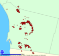
NOAA hot spot map of San Diego County, October 23, 2007.
-
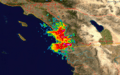
Weather radar imagery of the fires on October 23.
-

San Diego skyline against the smoke at sunrise, on October 23, 2007.
-
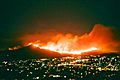
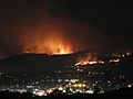
The Harris Fire burning on Mount San Miguel, on the morning of October 23, 2007
-
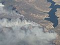
Aerial view of the Harris Fire on October 23, 2007, 12:05 pm.
-
The Poomacha Fire: photo taken looking South towards San Diego from Temecula
-
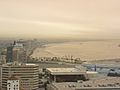
The skyline of Long Beach, California, looking east on the morning of October 24, 2007, with the sky filled with smoke.
-
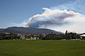
The Santiago Fire seen from Aliso Viejo, overlooking the city of Lake Forest, on October 23, 2007
-
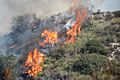
Fires burn across a hillside in Orange County.
-

Evacuees at evacuation site Mira Mesa High School
-
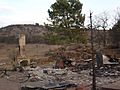
The remains of a home destroyed by the Witch Creek Fire


See also
 In Spanish: Incendios forestales en California de octubre de 2007 para niños
