Camden County, New Jersey facts for kids
Quick facts for kids
Camden County
|
|
|---|---|

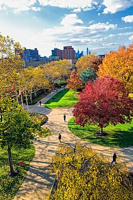
Campus of Rutgers University-Camden
|
|

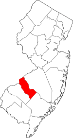
Location within the U.S. state of New Jersey
|
|
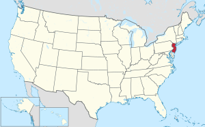
 New Jersey's location within the U.S. |
|
| Country | |
| State | |
| Founded | March 13, 1844 |
| Named for | Charles Pratt, 1st Earl Camden |
| Seat | Camden |
| Largest municipality | Cherry Hill (population) Winslow Township (area) |
| Area | |
| • Total | 227.293 sq mi (588.69 km2) |
| • Land | 221.263 sq mi (573.07 km2) |
| • Water | 6.030 sq mi (15.62 km2) 2.32% |
| Population
(2020)
|
|
| • Total | 523,485 |
| • Density | 2,365.9/sq mi (913.5/km2) |
| Congressional districts | 1st, 2nd |
Camden County is a county located in the U.S. state of New Jersey. As of the 2020 United States Census, the county's population was 523,485, an increase of 9,828 (1.9%) from the 2010 Census, making it the state's 8th-largest county, Its county seat is Camden. The most populous place was Cherry Hill Township with 74,553 residents at the time of the 2020 Census, while Winslow Township covered 58.19 square miles (150.7 km2), the largest total area of any municipality.
The county was formed on March 13, 1844, from portions of Gloucester County. The county was named for Charles Pratt, 1st Earl Camden, a British judge, civil libertarian, and defender of the American cause. Camden County is part of the Camden, NJ Metropolitan Division of the Philadelphia-Camden-Wilmington, PA-NJ-DE-MD / Delaware Valley Metropolitan Statistical Area.
Contents
Geography
According to the 2010 Census, the county had a total area of 227.293 square miles (588.69 km2), including 221.263 square miles (573.07 km2) of land (97.3%) and 6.030 square miles (15.62 km2) of water (2.7%).
Located in a coastal / alluvial plain, the county is uniformly flat and low-lying. The highest points are a survey benchmark near the Burlington County line at 219 feet (67 m) above sea level. The low point is sea level, along the Delaware River.
Adjacent counties
The county borders the following counties:
- Burlington County, New Jersey – northeast
- Atlantic County, New Jersey – southeast
- Gloucester County, New Jersey – southwest
- Philadelphia County, Pennsylvania – northwest
National protected area
Climate and weather
| Weather chart for Camden, New Jersey | |||||||||||||||||||||||||||||||||||||||||||||||
|---|---|---|---|---|---|---|---|---|---|---|---|---|---|---|---|---|---|---|---|---|---|---|---|---|---|---|---|---|---|---|---|---|---|---|---|---|---|---|---|---|---|---|---|---|---|---|---|
| J | F | M | A | M | J | J | A | S | O | N | D | ||||||||||||||||||||||||||||||||||||
|
3
40
26
|
2.8
44
28
|
3.8
53
34
|
3.6
64
44
|
3.7
74
54
|
3.4
83
64
|
4.4
87
69
|
3.5
85
68
|
3.8
78
60
|
3.2
67
48
|
3
56
39
|
3.6
45
30
|
||||||||||||||||||||||||||||||||||||
| temperatures in °F precipitation totals in inches source: The Weather Channel |
|||||||||||||||||||||||||||||||||||||||||||||||
|
Metric conversion
|
|||||||||||||||||||||||||||||||||||||||||||||||
In recent years, average temperatures in the county seat of Camden have ranged from a low of 26 °F (−3 °C) in January to a high of 87 °F (31 °C) in July, although a record low of −11 °F (−24 °C) was recorded in February 1934 and a record high of 106 °F (41 °C) was recorded in August 1918. Average monthly precipitation ranged from 2.75 inches (70 mm) in February to 4.35 inches (110 mm) in July.
Demographics
| Historical population | |||
|---|---|---|---|
| Census | Pop. | %± | |
| 1850 | 25,422 | — | |
| 1860 | 34,457 | 35.5% | |
| 1870 | 46,193 | 34.1% | |
| 1880 | 62,942 | 36.3% | |
| 1890 | 87,687 | 39.3% | |
| 1900 | 107,643 | 22.8% | |
| 1910 | 142,029 | 31.9% | |
| 1920 | 190,508 | 34.1% | |
| 1930 | 252,312 | 32.4% | |
| 1940 | 255,727 | 1.4% | |
| 1950 | 300,743 | 17.6% | |
| 1960 | 392,035 | 30.4% | |
| 1970 | 456,291 | 16.4% | |
| 1980 | 471,650 | 3.4% | |
| 1990 | 502,824 | 6.6% | |
| 2000 | 508,932 | 1.2% | |
| 2010 | 513,657 | 0.9% | |
| 2020 | 523,485 | 1.9% | |
| Historical sources: 1790–1990 1970–2010 2010 2020 |
|||
Camden County has 37 municipalities of diverse sizes and populations. Nine are less than one square mile in area, and five have fewer than 2,000 residents (excluding Tavistock and Pine Valley which are golf courses with nominal populations). Over half of county residents live in five municipalities having populations over 30,000 (Camden, Cherry Hill, Gloucester Township, Winslow, Pennsauken).
The 2018 ACS estimates show 25 municipalities with poverty rates below the statewide average (10.5%). Nine municipalities had poverty rates higher than the county-wide estimate (12.6%): Camden, Woodlynne, Chesilhurst, Lawnside, Bellmawr, Clementon, Blackwood, Brooklawn, and Lindenwold. Additionally, Cherry Hill and Voorhees are affluent areas with higher-poverty areas including Echelon and Ellisburg.
2020 Census
As of the Census of 2020, the county had 523,485 people, 187,780 households, and 125,806 families. The population density was 2,365.9 inhabitants per square mile (913.5/km2). There were 212,759 housing units at an average density of 961.5 per square mile (371.2/km2). The county's racial makeup was 56.0% White, 19.3% African American, 0.47% Native American, 6.22% Asian, and 8.14% from two or more races. Hispanic or Latino of any race were 18.2% of the population.
There were 187,780 households, of which 29.3% had children under the age of 18 living with them, 59.0% were married couples living together, 25.3% had a female householder with no husband present, 9.2% had a male householder with no wife present and 29.4% were non-families. 38.7% of all households were made up of individuals, and 11.0% had someone living alone who was 65 years of age or older. The average household size was 2.66 and the average family size was 3.30.
About 22.5% of the county's population was under age 18, 8.1% was from age 18 to 24, 38.7% was from age 15 to 44, and 16.1% was age 65 or older. The median age was 38.7 years. The gender makeup of the city was 48.3% male and 51.7% female. For every 100 females, there were 93.4 males.
The county's median household income was $73,672, and the median family income was $88,575. About 10.7% of the population were below the poverty line, including 17.4% of those under age 18 and 9.0% of those age 65 or over.
2010 Census
As of the census of 2010, there were 513,657 people, 190,980 households, and 129,866 families residing in the county. The population density was 2,321.5 per square mile (896.3/km2). There were 204,943 housing units at an average density of 926.2 per square mile (357.6/km2)*. The racial makeup of the county was 65.29% (335,389) White, 19.55% (100,441) Black or African American, 0.31% (1,608) Native American, 5.11% (26,257) Asian, 0.03% (165) Pacific Islander, 7.08% (36,354) from other races, and 2.62% (13,443) from two or more races. [[Hispanic (U.S. Census)|Hispanic or Latino of any race were 14.24% (73,124) of the population.
There were 190,980 households out of which 31.1% had children under the age of 18 living with them, 46.3% were married couples living together, 16.4% had a female householder with no husband present, and 32% were non-families. 26.3% of all households were made up of individuals, and 10% had someone living alone who was 65 years of age or older. The average household size was 2.65 and the average family size was 3.22.
In the county, the population was spread out with 24.4% under the age of 18, 9% from 18 to 24, 26.6% from 25 to 44, 27.2% from 45 to 64, and 12.8% who were 65 years of age or older. The median age was 37.9 years. For every 100 females there were 93.2 males. For every 100 females ages 18 and old there were 89.7 males.
Municipalities
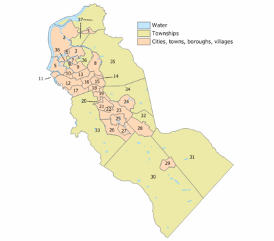
Municipalities in Camden County (with 2010 Census data for population, housing units and area) are:
| Municipality (with map key) |
Municipal type |
Population | Housing Units |
Total Area |
Water Area |
Land Area |
Pop. Density |
Housing Density |
Communities |
|---|---|---|---|---|---|---|---|---|---|
| Audubon (9) | borough | 8,819 | 3,779 | 1.50 | 0.02 | 1.49 | 5,925.7 | 2,539.2 | |
| Audubon Park (6) | borough | 1,023 | 499 | 0.16 | 0.01 | 0.15 | 7,046.7 | 3,437.3 | |
| Barrington (16) | borough | 6,983 | 3,158 | 1.61 | 0.00 | 1.61 | 4,346.0 | 1,965.4 | |
| Bellmawr (12) | borough | 11,583 | 4,883 | 3.11 | 0.13 | 2.98 | 3,887.7 | 1,638.9 | |
| Berlin (28) | borough | 7,588 | 2,949 | 3.60 | 0.01 | 3.59 | 2,114.9 | 821.9 | New Freedom |
| Berlin Township (32) | township | 5,357 | 2,069 | 3.24 | 0.01 | 3.23 | 1,657.5 | 640.2 | West Berlin |
| Brooklawn (11) | borough | 1,955 | 806 | 0.52 | 0.03 | 0.49 | 3,974.6 | 1,638.6 | |
| Camden (2) | city | 77,344 | 28,358 | 10.34 | 1.42 | 8.92 | 8,669.6 | 3,178.7 | |
| Cherry Hill (35) | township | 71,045 | 28,452 | 24.24 | 0.15 | 24.10 | 2,948.3 | 1,180.7 | Ashland CDP (8,302) Barclay CDP (4,428) Cherry Hill Mall CDP (14,171) Coffins Corner Ellisburg CDP (4,413) Golden Triangle CDP (4,145) Greentree CDP (11,367) Kingston Estates CDP (5,685) Springdale CDP (14,518) Woodcrest |
| Chesilhurst (29) | borough | 1,634 | 621 | 1.72 | 0.00 | 1.72 | 951.2 | 361.5 | |
| Clementon (25) | borough | 5,000 | 2,235 | 1.97 | 0.06 | 1.91 | 2,612.0 | 1,167.6 | |
| Collingswood (3) | borough | 13,926 | 6,822 | 1.92 | 0.10 | 1.82 | 7,639.4 | 3,742.3 | |
| Gibbsboro (24) | borough | 2,274 | 809 | 2.22 | 0.04 | 2.18 | 1,041.9 | 370.7 | |
| Gloucester City (5) | city | 11,456 | 4,712 | 2.78 | 0.46 | 2.32 | 4,937.8 | 2,031.0 | |
| Gloucester Township (33) | township | 64,634 | 24,711 | 23.26 | 0.28 | 22.98 | 2,812.2 | 1,075.2 | Blackwood CDP (4,545) Blenheim Chews Landing Erial Glendora CDP (4,750) Grenloch Lakeland |
| Haddon Township (36) | township | 14,707 | 6,477 | 2.79 | 0.10 | 2.69 | 5,472.6 | 2,410.1 | |
| Haddonfield (8) | borough | 11,593 | 4,634 | 2.87 | 0.05 | 2.82 | 4,104.9 | 1,640.8 | |
| Haddon Heights (13) | borough | 7,473 | 3,159 | 1.57 | 0.01 | 1.57 | 4,764.1 | 2,013.9 | |
| Hi-Nella (20) | borough | 870 | 420 | 0.23 | 0.00 | 0.23 | 3,773.3 | 1,821.6 | |
| Laurel Springs (22) | borough | 1,908 | 771 | 0.47 | 0.01 | 0.46 | 4,163.7 | 1,682.5 | |
| Lawnside (15) | borough | 2,945 | 1,174 | 1.41 | 0.00 | 1.41 | 2,091.5 | 833.7 | |
| Lindenwold (23) | borough | 17,613 | 8,251 | 3.95 | 0.06 | 3.89 | 4,525.1 | 2,119.8 | |
| Magnolia (18) | borough | 4,341 | 1,850 | 0.97 | 0.00 | 0.97 | 4,485.3 | 1,911.5 | |
| Merchantville (1) | borough | 3,821 | 1,688 | 0.60 | 0.00 | 0.60 | 6,371.3 | 2,814.6 | |
| Mount Ephraim (10) | borough | 4,676 | 2,010 | 0.90 | 0.02 | 0.88 | 5,307.9 | 2,281.6 | |
| Oaklyn (7) | borough | 4,038 | 1,847 | 0.69 | 0.07 | 0.63 | 6,432.9 | 2,942.4 | |
| Pennsauken Township (37) | township | 35,885 | 13,275 | 12.08 | 1.65 | 10.44 | 3,438.9 | 1,272.2 | |
| Pine Hill (26) | borough | 10,233 | 4,357 | 3.91 | 0.04 | 3.87 | 2,643.4 | 1,125.5 | |
| Pine Valley (27) | borough | 12 | 22 | 1.00 | 0.02 | 0.98 | 12.2 | 22.4 | |
| Runnemede (17) | borough | 8,468 | 3,548 | 2.11 | 0.06 | 2.06 | 4,117.2 | 1,725.1 | |
| Somerdale (19) | borough | 5,151 | 2,158 | 1.39 | 0.00 | 1.39 | 3,714.0 | 1,556.0 | |
| Stratford (21) | borough | 7,040 | 2,761 | 1.55 | 0.00 | 1.55 | 4,547.0 | 1,783.3 | |
| Tavistock (14) | borough | 5 | 3 | 0.26 | 0.00 | 0.25 | 19.7 | 11.8 | |
| Voorhees Township (34) | township | 29,131 | 12,260 | 11.64 | 0.15 | 11.49 | 2,534.9 | 1,066.8 | Echelon CDP (10,743) Glendale Kirkwood Kresson Osage Woodcrest Acres |
| Waterford Township (31) | township | 10,649 | 3,839 | 36.27 | 0.23 | 36.04 | 295.5 | 106.5 | Atco Jackson Louden |
| Winslow Township (30) | township | 39,499 | 14,560 | 58.19 | 0.85 | 57.34 | 688.8 | 253.9 | Albion Ancora Blue Anchor Braddock Cedar Brook Elm Ivystone Farms Sicklerville Tansboro Waterford Works West Atco |
| Woodlynne (4) | borough | 2,978 | 1,016 | 0.23 | 0.01 | 0.22 | 13,600.4 | 4,640.0 | |
| Camden County | county | 513,657 | 204,943 | 227.29 | 6.03 | 221.26 | 2,321.5 | 926.2 |
Historical municipalities
Defunct municipalities in the county (with years of formation and dissolution listed in parentheses) include:
- Centre Township (1855–1926)
- Clementon Township (1903–1941)
- Delaware Township (renamed as Cherry Hill)
- Newton Township (1695–1871)
- Stockton Township (1859–1899)
- Union Township (1831–1868)
Arts and culture
Fine and performing arts
Symphony in C is based on the campus of Rutgers University-Camden
Perkins Center for the Arts has locations in Moorestown and Collingswood.
Literature
Poet Walt Whitman lived in Camden County.
Matthew Quick's novel The Silver Linings Playbook takes place in Collingswood and Voorhees, although the screen adaptation is set in Pennsylvania.
Film
The Last Broadcast was partially filmed in the Pine Barrens.
Harold and Kumar Go to White Castle is partially set in Cherry Hill.
Camden was the setting for several scenes in 12 Monkeys.
Transportation
Roads and highways
Camden County hosts numerous county, state, U.S. and Interstates. As of October 2015[update], the county had a total of 2,045.06 miles (3,291.21 km) of roadways, of which 1,535.22 miles (2,470.70 km) are maintained by the municipality, 377.65 miles (607.77 km) by Camden County and 104.41 miles (168.03 km) by the New Jersey Department of Transportation, 5.11 miles (8.22 km) by the Delaware River Port Authority, 9.07 miles (14.60 km) by the New Jersey Turnpike Authority and 13.60 miles (21.89 km) by the South Jersey Transportation Authority.
Major county roads that pass through include County Road 534, County Road 536, County Road 537, County Road 543, County Road 544, County Road 551 and County Road 561.
State routes that pass through are Route 38, Route 41, Route 42 (the North-South Freeway), Route 47 (only in Brooklawn), Route 70, Route 73, Route 90 (the Betsy Ross Bridge), Route 143 (only in Winslow), Route 154 (only in Cherry Hill) and Route 168.
U.S. Routes that traverse are U.S. Route 30 and U.S. Route 130.
The interstates that pass through are Interstate 76 (part of the North-South Freeway and the Walt Whitman Bridge), Interstate 295 and Interstate 676 (part of the North-South Freeway and the Ben Franklin Bridge (which is multiplexed with US 30)).
Other limited access roads that pass through are the Atlantic City Expressway and the New Jersey Turnpike. There are five ACE interchanges that are within the county borders: Exits 44 (at NJ 42), 41 (at Berlin-Cross Keys Road / CR 689), 38 (at Williamstown-New Freedom Road / CR 536 Spur), 33 (connecting to NJ 73) and 31 (at NJ 73). The only turnpike interchange that is in the county is Exit 3 at the border of Runnemede and Bellmawr.
Public transportation
NJ Transit has stations along the Atlantic City Line in Pennsauken, Cherry Hill, Lindenwold and Atco in Waterford Township, connecting Philadelphia to Atlantic City along the former Pennsylvania-Reading Seashore Lines main line.
The River Line is a diesel tram-train light-rail system operated for NJ Transit by the Southern New Jersey Rail Group on a former Pennsylvania Railroad line from Trenton. Most stations in the county are in the Camden, including the Walter Rand Transportation Center, except for the 36th Street, Pennsauken Transit Center and Pennsauken–Route 73 station located in Pennsauken Township.
The PATCO Speedline, owned by the Delaware River Port Authority, runs a rapid transit line across the Ben Franklin Bridge from Philadelphia through Camden to the PRSL main right-of-way between Haddonfield and its eastern terminus in Lindenwold. Suburban station stops include Woodcrest, Westmont and Collingswood.
NJ Transit provides commuter and long-distance bus service from many locations in the county to Philadelphia, with additional service to Atlantic City. Extensive local service is offered within the county, including routes to Camden and area train and light rail stations.
Economy
Based on data from the Bureau of Economic Analysis, Camden County had a gross domestic product (GDP) of $23.8 billion in 2018, which was ranked 11th in New Jersey and represented an increase of 2.5% from the previous year.
Education
Colleges and universities
Rutgers University-Camden is located in the downtown/waterfront district of Camden, and dates back to 1926 with the founding of the South Jersey Law School.
Rutgers School of Law–Camden is one of two campuses of Rutgers Law School, the other being in Newark.
The Rowan University School of Osteopathic Medicine is located in Stratford and dates to 1976. It is the state's only osteopathic medical school and was South Jersey's first four-year college of medicine.
The Cooper Medical School of Rowan University is located in the downtown/university district of Camden. Established as a four-year medical school in 1975, the relationship with Rowan University was formed in 2008.
Rutgers Biomedical and Health Sciences has a campus in Stratford which hosts its dental school and school of public health.
Rowan University at Camden is located on Cooper Street in Camden and offers undergraduate and graduate degrees.
Camden County College is a two-year public community college serving students from Camden County. The school has campuses in Blackwood, Camden and Cherry Hill, and was founded in 1967.
See also
 In Spanish: Condado de Camden (Nueva Jersey) para niños


