
Cameron County, Texas facts for kids
Quick facts for kids
Cameron County
|
|||
|---|---|---|---|
| County of Cameron | |||

The current Cameron County Courthouse in Brownsville
|
|||
|
|||

Location within the U.S. state of Texas
|
|||
 Texas's location within the U.S. |
|||
| Country | |||
| State | |||
| Founded | 1848 | ||
| Named for | Ewen Cameron | ||
| Seat | Brownsville | ||
| Largest city | Brownsville | ||
| Area | |||
| • Total | 1,276 sq mi (3,300 km2) | ||
| • Land | 891 sq mi (2,310 km2) | ||
| • Water | 386 sq mi (1,000 km2) 30% | ||
| Population
(2020)
|
|||
| • Total | 421,017 | ||
| • Density | 329.95/sq mi (127.39/km2) | ||
| Time zone | UTC−6 (Central) | ||
| • Summer (DST) | UTC−5 (CDT) | ||
| Congressional district | 34th | ||

Cameron County, officially the County of Cameron, is the southernmost county in the U.S. state of Texas. As of the 2020 census, its population was 421,017. Its county seat is Brownsville.
The county was founded in 1848 and is named for Captain Ewen Cameron, a soldier during the Texas Revolution and in the ill-fated Mier Expedition. During the later 19th century and through World War II, Fort Brown was a US Army outpost here, stimulating the development of the city of Brownsville.
Cameron County is part of the Brownsville–Harlingen, TX metropolitan statistical area, as well as the Brownsville–Harlingen–Raymondville combined statistical area, which itself is part of the larger Rio Grande Valley region.
Contents
Geography
According to the U.S. Census Bureau, the county has a total area of 1,276 square miles (3,300 km2), of which 891 square miles (2,310 km2) is land and 386 square miles (1,000 km2) (30%) is water. To the east, the county borders the Gulf of Mexico.
Major highways
 Interstate 2
 Interstate 69E
 Interstate 169 (Under Construction)
 U.S. Highway 77
 U.S. Highway 83
 U.S. Highway 281
 State Highway 4
 State Highway 48
 State Highway 100
 State Highway 107
 State Highway 345
 State Highway 550
Adjacent counties and municipalities
- Willacy County, Texas (north)
- Hidalgo County, Texas (west)
- Matamoros Municipality, Tamaulipas, Mexico (south)
National protected areas
- Laguna Atascosa National Wildlife Refuge (part)
- Lower Rio Grande Valley National Wildlife Refuge (part)
- Palo Alto Battlefield National Historic Site
Demographics
| Historical population | |||
|---|---|---|---|
| Census | Pop. | %± | |
| 1850 | 8,541 | — | |
| 1860 | 6,028 | −29.4% | |
| 1870 | 10,999 | 82.5% | |
| 1880 | 14,959 | 36.0% | |
| 1890 | 14,424 | −3.6% | |
| 1900 | 16,095 | 11.6% | |
| 1910 | 27,158 | 68.7% | |
| 1920 | 36,662 | 35.0% | |
| 1930 | 77,540 | 111.5% | |
| 1940 | 83,202 | 7.3% | |
| 1950 | 125,170 | 50.4% | |
| 1960 | 151,098 | 20.7% | |
| 1970 | 140,368 | −7.1% | |
| 1980 | 209,680 | 49.4% | |
| 1990 | 260,120 | 24.1% | |
| 2000 | 335,227 | 28.9% | |
| 2010 | 406,220 | 21.2% | |
| 2020 | 421,017 | 3.6% | |
| U.S. Decennial Census 1850–2010 2010 2020 |
|||
2020 census
| Race / Ethnicity | Pop 2010 | Pop 2020 | % 2010 | % 2020 |
|---|---|---|---|---|
| White alone (NH) | 43,427 | 37,107 | 10.69% | 8.81% |
| Black or African American alone (NH) | 1,192 | 1,405 | 0.29% | 0.33% |
| Native American or Alaska Native alone (NH) | 385 | 365 | 0.09% | 0.09% |
| Asian alone (NH) | 2,486 | 2,596 | 0.61% | 0.62% |
| Pacific Islander alone (NH) | 76 | 80 | 0.02% | 0.02% |
| Some Other Race alone (NH) | 191 | 846 | 0.05% | 0.20% |
| Mixed Race/Multi-Racial (NH) | 716 | 1,938 | 0.18% | 0.46% |
| Hispanic or Latino (any race) | 357,747 | 376,680 | 88.07% | 89.47% |
| Total | 406,220 | 421,017 | 100.00% | 100.00% |
Note: the US Census treats Hispanic/Latino as an ethnic category. This table excludes Latinos from the racial categories and assigns them to a separate category. Hispanics/Latinos can be of any race.
2010 Census
As of the census of 2010, 406,220 people, 119,631 households, and 96,579 families were residing in the county. The population density was 370 people per square mile (143/km2). The 141,924 housing units averaged 132 per square mile (51/km2). The racial makeup of the county was 87.0% White, 0.5% African American, 0.4% Native American, 0.7% Asian, 9.8% from other races, and 1.5% from two or more races. About 88.1% of the population was Hispanic or Latino of any race.
Of the 119,631 households, 50.3% had children under the age of 18 living with them, 60.80% were married couples living together, 20.0% had a female householder with no husband present, and 19.3% were not families. About 16.40% of all households were made up of individuals, and 7.30% had someone living alone who was 65 years of age or older. The average household size was 3.36, and the average family size was 3.80.
In the county, the age distribution was 33.0% under the age of18, 9.7% from 18 to 24, 25.6% from 25 to 44, 20.6% from 45 to 64, and 11.10% who were 65 or older. The median age was 30.6 years. For every 100 females, there were 91.90 males. For every 100 females aged 18 and over, there were 86.30 males.
The median income for a household in the county was $31,264, and for a family was $33,770. Males had a median income of $21,410 versus $15,597 for females. The per capita income for the county was $13,695. About 30.0% of families and 34.7% of the population were below the poverty line, including 46.8% of those under age 18 and 24.8% of those age 65 or over.
A 2000 Texas A&M study stated that of the residents of Cameron County, 43% do not have basic literacy skills.
Within the 2010s decade, a noticeable trend in the county population showed that growth among the county's northern cities (defined as major towns whose city limits lie entirely north or east of U.S. Highway 83 in the county) on average has been greater than those cities on U.S. Highway 83 in the county, suggesting a possible desire among both locals and new residents from outside the Rio Grande Valley to move away from the population centers of the county. This trend has also been shared by nearby Hidalgo County. Los Fresnos, for example, grew by 42.2% from 2010 to 2018. Other major cities, such as Indian Lake, Primera, and Rio Hondo, all grew by more than 15% in the same period. In contrast, the cities of Harlingen, La Feria, and San Benito, all cities along U.S. Highway 83, have seen growths less than 1% in the same period. The city that grew the most among the Highway 83 cities in the county was Brownsville, which grew by 4.4% from 2010 to 2019.
Communities
Cities
- Brownsville (county seat)
- Harlingen
- La Feria
- Los Fresnos
- Palm Valley
- Port Isabel
- Rio Hondo
- San Benito
Towns

Village
Census-designated places
- Arroyo Colorado Estates
- Arroyo Gardens
- Bixby
- Bluetown
- Cameron Park
- Chula Vista
- Del Mar Heights
- El Camino Angosto
- Encantada-Ranchito-El Calaboz
- Grand Acres (former)
- Green Valley Farms
- Iglesia Antigua
- Juarez
- La Feria North
- La Paloma
- La Tina Ranch
- Lago
- Laguna Heights
- Las Palmas II
- Lasana
- Laureles
- Lozano
- Olmito
- Orason
- Ratamosa
- Reid Hope King
- San Pedro
- Santa Maria
- Solis
- South Point
- Tierra Bonita
- Villa del Sol
- Villa Pancho
- Yznaga
Other unincorporated communities
Ghost town
Economy
SpaceX has been approved by the FAA to build a private spaceport east of Brownsville on the Gulf Coast.
The SpaceX South Texas Launch Site is projected to employ 75–100 full-time workers in the early years with up to 150 full-time employees/contractors by 2019. In 2014, SpaceX acquired additional land near Boca Chica, which they consolidated into a subdivision called "Mars Crossing", possibly named after the novel by science-fiction writer Geoffrey A. Landis.
-
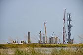
View of SpaceX's launch pad at Boca Chica Village near Brownsville.
-
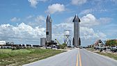
SN15 and SN16.
-
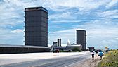
Starship and SuperHeavy production site.
.jpg)
.jpg)
.jpg)
Education
Cameron County is served by several school districts. They include:
- Brownsville Independent School District
- Harlingen Consolidated Independent School District
- La Feria Independent School District
- Los Fresnos Consolidated Independent School District
- Lyford Consolidated Independent School District (partially)
- Point Isabel Independent School District
- Rio Hondo Independent School District
- San Benito Consolidated Independent School District
- Santa Maria Independent School District
- Santa Rosa Independent School District
In addition, residents are eligible to apply to South Texas Independent School District's magnet schools.
All of the county is in the service area of Texas Southmost College.
See also
 In Spanish: Condado de Cameron (Texas) para niños
