
Campbell, California facts for kids
Quick facts for kids
City of Campbell
|
||
|---|---|---|

Campbell's welcome sign
|
||
|
||

Location of Campbell in Santa Clara County, California
|
||

Campbell, California
Location in San Francisco Bay Area

Campbell, California
Location in California

Campbell, California
Location in the United States
|
||
| Country | United States | |
| State | California | |
| County | Santa Clara | |
| Incorporated | March 28, 1952 | |
| Government | ||
| • Type | Council-Manager | |
| Area | ||
| • Total | 6.10 sq mi (15.80 km2) | |
| • Land | 6.08 sq mi (15.75 km2) | |
| • Water | 0.02 sq mi (0.05 km2) 1.49% | |
| Elevation | 200 ft (61 m) | |
| Population
(2020)
|
||
| • Total | 43,959 | |
| • Density | 7,228.91/sq mi (2,791.25/km2) | |
| Time zone | UTC−8 (Pacific) | |
| • Summer (DST) | UTC−7 (PDT) | |
| ZIP codes |
95008, 95009, 95011
|
|
| Area codes | 408/669 | |
| FIPS code | 06-10345 | |
| GNIS feature IDs | 277483, 2409971 | |

Campbell is a city in Santa Clara County, California, in the San Francisco Bay Area. As of the 2020 U.S. Census, Campbell's population is 44,028.
Campbell is home to the Pruneyard Shopping Center, a sprawling open-air retail complex which was involved in a famous U.S. Supreme Court case that established the extent of the right to free speech in California. Today, the Pruneyard Shopping Center is home to the South Bay offices of the Federal Bureau of Investigation.
Contents
Geography
Campbell is bordered on the east and north by San Jose, on the south by Los Gatos, and on the west by a small portion of Saratoga.
According to the United States Census Bureau, the city has a total area of 5.9 square miles (15 km2). 5.8 square miles (15 km2) of it is land and 0.1 square miles (0.26 km2) of it is water.
Of the total area, 1.49% is water, consisting of percolation ponds in Los Gatos Creek Park and in other locations; San Tomas Aquino Creek, which flows north on the west side of the city, is completely enclosed with fences and runs through concrete culverts; and Los Gatos Creek, which flows north-north-east on the east side of the city and has paths along both banks for hikers and joggers (locally called the "Perc Ponds").
State Route 17 runs roughly parallel to Los Gatos Creek on its eastern side; State Route 85 runs roughly east–west through Los Gatos just south of Campbell and cuts through the southwest corner of the city.
Demographics
| Historical population | |||
|---|---|---|---|
| Census | Pop. | %± | |
| 1960 | 11,863 | — | |
| 1970 | 23,797 | 100.6% | |
| 1980 | 26,843 | 12.8% | |
| 1990 | 36,048 | 34.3% | |
| 2000 | 38,138 | 5.8% | |
| 2010 | 39,349 | 3.2% | |
| 2020 | 43,959 | 11.7% | |
| U.S. Decennial Census | |||
2010
The 2010 United States Census reported that Campbell had a population of 39,349. The population density was 6,685.2 people per square mile (2,581.2/km2).
The racial makeup of Campbell was 26,315 (66.9%) White, 7,247 (18.4%) Hispanic or Latino of any race, 6,320 (16.1%) Asian, 1,158 (2.9%) African American, 275 (0.7%) Native American, and 161 (0.4%) Pacific Islander. A remaining 2,713 (6.9%) identified as other races, and 2,407 (6.1%) from two or more races.
The Census reported that 39,148 people (99.5% of the population) lived in households, 79 (0.2%) lived in non-institutionalized group quarters, and 122 (0.3%) were institutionalized.
There were 16,163 households, out of which 4,897 (30.3%) had children under the age of 18 living in them, 7,133 (44.1%) were opposite-sex married couples living together, 1,741 (10.8%) had a female householder with no husband present, 812 (5.0%) had a male householder with no wife present. There were 1,092 (6.8%) unmarried opposite-sex partnerships, and 138 (0.9%) same-sex married couples or partnerships. 4,805 households (29.7%) were made up of individuals, and 1,328 (8.2%) had someone living alone who was 65 years of age or older. The average household size was 2.42. There were 9,686 families (59.9% of all households); the average family size was 3.05.
The population was spread out, with 8,271 people (21.0%) under the age of 18, 2,982 people (7.6%) aged 18 to 24, 12,834 people (32.6%) aged 25 to 44, 10,868 people (27.6%) aged 45 to 64, and 4,394 people (11.2%) who were 65 years of age or older. The median age was 38.3 years. For every 100 females, there were 96.2 males. For every 100 females age 18 and over, there were 94.2 males.
There were 16,950 housing units at an average density of 2,879.7 per square mile (1,111.9/km2), of which 8,093 (50.1%) were owner-occupied, and 8,070 (49.9%) were occupied by renters. The homeowner vacancy rate was 1.8%; the rental vacancy rate was 4.6%. 20,975 people (53.3% of the population) lived in owner-occupied housing units and 18,173 people (46.2%) lived in rental housing units.
|
2000
As of the census of 2000, there were 39,200 people, 15,920 households, and 9,122 families residing in the city. The population density was 6,802.8 inhabitants per square mile (2,624.8/km2). There were 16,286 housing units at an average density of 2,905.0 per square mile (1,120.9/km2). The racial makeup of the city was 72.78% White, 2.53% African American, 0.65% Native American, 14.16% Asian, 0.23% Pacific Islander, 4.87% from other races, and 4.77% from two or more races. Hispanic or Latino of any race were 13.33% of the population.
28.0% of the households had children under the age of 18 living with them, 42.6% were married couples living together, 10.1% had a female householder with no husband present, and 42.7% were non-families. 30.4% of all households were made up of individuals, and 7.0% had someone living alone who was 65 years of age or older. The average household size was 2.38 and the average family size was 3.02.
The city population was 21.6% under the age of 18, 7.6% from 18 to 24, 40.2% from 25 to 44, 20.9% from 45 to 64, and 9.7% who were 65 years of age or older. The median age was 35 years. For every 100 females, there were 98.6 males. For every 100 females age 18 and over, there were 96.7 males.
About 48% of the adult population has at least one college-level degree. However, this has declined in recent years as a greater number of working-class immigrants move into the city.
The median income for a household in the city was $67,214, and the median income for a family was $78,663 (these figures had risen to $70,928 and $89,285 respectively as of a 2007 estimate). Males had a median income of $52,454 versus $43,750 for females. The per capita income for the city was $34,441. About 3.2% of families and 4.8% of the population were below the poverty line, including 4.2% of those under age 18 and 8.3% of those age 65 or over.
Climate
Campbell has a Mediterranean climate, characterized by mild, wet winters and warm, dry summers.
| Climate data for Campbell, California | |||||||||||||
|---|---|---|---|---|---|---|---|---|---|---|---|---|---|
| Month | Jan | Feb | Mar | Apr | May | Jun | Jul | Aug | Sep | Oct | Nov | Dec | Year |
| Record high °F (°C) | 79 (26) |
80 (27) |
88 (31) |
96 (36) |
101 (38) |
114 (46) |
113 (45) |
107 (42) |
109 (43) |
103 (39) |
87 (31) |
83 (28) |
114 (46) |
| Average high °F (°C) | 58 (14) |
62 (17) |
66 (19) |
70 (21) |
76 (24) |
81 (27) |
85 (29) |
84 (29) |
82 (28) |
75 (24) |
64 (18) |
57 (14) |
72 (22) |
| Average low °F (°C) | 39 (4) |
41 (5) |
43 (6) |
45 (7) |
49 (9) |
52 (11) |
55 (13) |
55 (13) |
53 (12) |
49 (9) |
43 (6) |
39 (4) |
47 (8) |
| Record low °F (°C) | 18 (−8) |
21 (−6) |
27 (−3) |
30 (−1) |
34 (1) |
37 (3) |
37 (3) |
39 (4) |
38 (3) |
31 (−1) |
28 (−2) |
16 (−9) |
16 (−9) |
| Average precipitation inches (mm) | 4.94 (125) |
5.06 (129) |
3.63 (92) |
1.40 (36) |
.54 (14) |
.10 (2.5) |
0 (0) |
.03 (0.76) |
.18 (4.6) |
1.01 (26) |
2.37 (60) |
4.01 (102) |
23.27 (591.86) |
| Source: Weather Channel | |||||||||||||
History
Campbell was founded by Benjamin Campbell, after whom the city was named. He came to California in 1846 with his father, William Campbell. William started a sawmill in Saratoga and surveyed the cities of San Jose and Santa Clara. In 1851, Benjamin bought 160 acres (0.65 km2) in southern Santa Clara Valley and cultivated hay and grain on it. This area later became Campbell's historical downtown core.
About a third of Campbell was a part of the 1839 Alta California Rancho Rinconada de Los Gatos land grant. The Northern extent of the granted land was along present-day Rincon Avenue and across the North end of John D. Morgan Park in central Campbell.
In 1878, Campbell sold his land for $5 an acre to a railroad company. By 1887, the first subdivision was recorded west of the railroad from Campbell Avenue to the spot where the Water Tower Plaza now stands. The area became the center for shipping fruit grown in the surrounding area, and within a short time, the drying grounds and canneries made Campbell an important rail center. The Campbell Fruit Growers' Union became a well-known cooperative with its 17-acre (69,000 m2) drying yard. J.C. Ainsley Packing Company, Hyde Cannery, and Payne Cannery were the main fruit packing companies. The Bank of Campbell was founded in 1895.
Campbell was officially incorporated as a city in 1952. The city then grew rapidly as orchard lands disappeared tract by tract. Today, Campbell is a suburban residential neighborhood in the southern part of the Santa Clara Valley.
Layout

Campbell is situated in the southern portion of the Santa Clara Valley, with Highway 17 passing through eastern Campbell and Highway 85 to its south. The historic downtown section sits just west of the railroad in the central area. The southwestern area of Campbell is known as the San Tomas neighborhood and varies somewhat from most of Campbell in the size of its lots and styles of housing. Hamilton Avenue is one the northernmost roads in Campbell.
The largest park in Campbell is Los Gatos Creek Park near Highway 17, and the second largest is John D. Morgan Park.
Transportation
 State Route 17
 State Route 85
 Interstate 280
Campbell is served by several major roads, including State Route 17, State Route 85, Interstate 280, and San Tomas Expressway (Santa Clara County Route G4). Major local arterial roads include Winchester Boulevard and Bascom Avenue.
Public transport in Campbell is operated by the Santa Clara Valley Transportation Authority and includes several local and express bus lines that link the community to nearby towns, including Cupertino, Los Gatos, Palo Alto, San Jose, Santa Clara and Saratoga. Additionally, the town is served by three light rail stations on the Mountain View - Winchester line, including Hamilton Station, Downtown Campbell Station, and the line's terminus at Winchester Station. These stations were opened as part of the first phase of the Vasona Light Rail project; the line will be extended past Winchester to Vasona Junction in Los Gatos once funding is secured. That line is now served by buses.
The extension was the subject of a minor dispute with the Federal Railroad Administration over the sounding of train horns late at night. This dispute delayed the opening of most of the extension for two months before the grand opening on October 1, 2005.
Points of interest
Landmarks

In the early 1990s, the Ainsley House a unique English Tudor-style house built in 1925, was moved from its original site at the corner of Hamilton and Bascom Avenues (the current site of eBay's headquarters) to the downtown quad and furnished with many of the Ainsley family's original furnishings. It has become the centerpiece for the Ainsley House and Campbell Historical Museum, which houses additional exhibits in the nearby old firehouse. The Ainsley House was built in the style of English country cottages for John Colpitts Ainsley, a canning pioneer in Santa Clara County, which was at the time known for its vast spreads of fruit orchards.

The Campbell Community Center is located on the northwest corner of Winchester and Campbell Avenues, in the building that used to be Campbell High School, the original school in the Campbell Union High School District. The Redwood Tree, which stands at the corner of Winchester Boulevard and Campbell Avenue was originally planted there on May 11, 1903 by then President, Teddy Roosevelt. The city acquired the property on August 1, 1985, five years after the school shut down. The Heritage Theater, formerly the high school's auditorium, was reopened after renovations in 2004 as an entertainment and event venue. The Community Center holds classes, and portions are available to be rented for various events.

The Campbell Water Tower is a highly visible remnant of Campbell's "small town" past and located on the site of the original city water company and pumping plant near downtown.
Campbell used to be the home of the Winchester Drive-In Theater (now a business park) and is also home to a number of public parks that include John D. Morgan Park, Campbell Park, Edith Morley Park (the site of the city's community garden program), Jack Fischer Park, the Los Gatos Creek Trail Park, Orchard City Green, and Stojanovich Family Park.

The Dubcich farm located on West Campbell Ave. near Morgan Park is Campbell's last remaining piece of agricultural property and connection to the city's agrarian origins. It is still intact with its original farm house dating back to the 1920s, barn, and fruit trees.
Athletics
Campbell for many years had one of the most successful youth baseball programs in the country, reaching 14 World Series from 1960-87.
Campbell’s youth baseball system dates to 1909, when Campbell High School formed its first team and won the Interurban Athletic Union championship. The community’s first non-scholastic youth baseball organization was the Junior Hardball League, which began in 1947. In 1954, Campbell Little League and Campbell Pony League began operation, and Moreland Little League, which is located in west San Jose but historically has served many Campbell residents, started in 1959.
Moreland in 1962 became the only Northern California team to win a Little League World Series, with 6-foot-1, 210-pound Ted Campbell pitching a no-hitter in a 3-0 victory over Kankakee, Illinois, in the championship game. Campbell Little League reached the Little League World Series championship game in 1970, 1976 and 1979, becoming one of only two American leagues to go to the LLWS three times in one decade. In all, Campbell-system teams have won six youth baseball World Series and finished second five times. Nine future major leaguers played in the Campbell youth baseball system: Don Hahn, George Tsamis, Steve Davis, Dan Gladden, Doug Capilla, Rich Troedson, Joe Ferguson, John Oldham and Greg Gohr.
“The Last Baseball Town,” a book by Campbell resident Chuck Hildebrand that chronicles the city’s baseball heritage, was published in May 2009.
Economy
8x8, Barracuda Networks, Move, ChargePoint, Hightail and ZURB are among the companies based in Campbell.
Top employers
According to the city's 2021 Comprehensive Annual Financial Report, the top employers in the city are:
| # | Employer | # of Employees |
|---|---|---|
| 1 | Chargepoint, Inc. | 1,029 |
| 2 | 8x8, Inc. | 742 |
| 3 | Barracuda Networks Inc. | 315 |
| 4 | Home Depot | 230 |
| 5 | Family Matters In-Home Care | 210 |
| 6 | Whole Foods Market | 208 |
| 7 | Moss Adams LLP | 201 |
| 8 | Saama Technologies | 185 |
| 9 | Bioreference Laboratories Inc. | 170 |
| 10 | Groupware Technology Inc. | 170 |
Education
Campbell public schools belong to two districts, the Campbell Union School District and the Campbell Union High School District. Of these districts, the schools located within the city are Campbell School of Innovation (K-8), Capri Elementary, Rosemary Elementary, Village School, and Westmont High School. Forest Hill Elementary School's campus is partially located in Campbell as well. Westmont High School is home to one of the few enduring Future Farmers of America programs left in the San Francisco Bay Area.
Within the school districts, there are 19 Campbell elementary schools, 9 Campbell middle schools, 3 Campbell high schools and 28 Campbell preschool schools. There are also 13 private schools in Campbell.
Santa Clara County Library operates the Campbell Library, which is currently relocated to the Campbell Community Center while it's being renovated.
Notable people
The following is a list of notable individuals who were born, raised, and/or residents in the City of Campbell.
- Alan Aerts, world powerlifting champion, former owner (now retired) of Custom Vending Systems, and Campbell "Citizen of the Year" in 2005 and 2006
- Sylvia Browne, psychic, spiritualist, author with her office in Campbell for many years.
- Brett Dalton, actor, attended Westmont High School.
- Claire Lobrovich, All-American Girls Professional Baseball League player, born and raised in Campbell
- Evan Low, state assemblyman, former mayor and city councilman, one of the youngest Asian-American and openly gay politicians in the U.S.
Images for kids
-
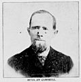
Benjamin Campbell (1826–1907)
-
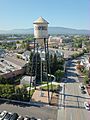
Campbell Water Tower
_%E2%80%94_Campbell_Weekly_Visitor_1895-06-07_page_2_crop.jpg)

See also
 In Spanish: Campbell (California) para niños
