
Cannon Falls, Minnesota facts for kids
Quick facts for kids
Cannon Falls, Minnesota
|
|
|---|---|
|
City
|
|

Buildings in downtown Cannon Falls
|
|

Location of Cannon Falls, Minnesota
|
|

Cannon Falls, Minnesota
Location in Minnesota

Cannon Falls, Minnesota
Location in the United States
|
|
| Country | United States |
| State | Minnesota |
| County | Goodhue |
| Area | |
| • Total | 4.59 sq mi (11.89 km2) |
| • Land | 4.49 sq mi (11.62 km2) |
| • Water | 0.10 sq mi (0.26 km2) |
| Elevation | 837 ft (255 m) |
| Population
(2010)
|
|
| • Total | 4,083 |
| • Estimate
(2019)
|
4,220 |
| • Density | 902.41/sq mi (348.39/km2) |
| Time zone | UTC-6 (Central (CST)) |
| • Summer (DST) | UTC-5 (CDT) |
| ZIP code |
55009
|
| Area code(s) | 507 |
| FIPS code | 27-09730 |
| GNIS feature ID | 0640870 |
| Website | http://cannonfallsmn.gov/ |
Cannon Falls is a city in Goodhue County, Minnesota, United States. The population was 4,083 at the 2010 census. Located along U.S. Route 52, southeast of the Twin Cities, Cannon Falls is the home of Pachyderm Studio, where many famous musicians have recorded, including Nirvana, which recorded its 1993 album In Utero there.
Cannon Falls is named for the falls along the Cannon River and serves as the western trailhead for the Cannon Valley Trail. Colonel William J. Colvill, a hero of the Battle of Gettysburg, is buried in the Cannon Falls Cemetery. Two American presidents have visited the city. The first, Calvin Coolidge, visited in 1928 to dedicate the memorial erected in honor of Colvill. The second, Barack Obama, held a town hall-style discussion at Hannah's Bend Park on August 15, 2011, while campaigning for a second term.
Contents
History
The first settler was Edway Stoughton. Charles Parks settled the land that is now the village of Cannon Falls in July 1854. Cannon Falls village proper was laid out by Richard and William Freeborn and was platted in 1855 by county surveyor S. A. Hart. The village was incorporated March 10, 1857. A post office was established as Cannon River Falls in 1855, and the name of the post office was shortened to Cannon Falls in 1889. Cannon Falls was reincorporated as a city in 1905.
An abundance of water power from both the big Cannon River and the Little Cannon River attracted manufacturers and capital investment. The first flouring mill was built by R. C. Knox & Co., in 1957. Other manufacturers, such as a wool mill, a grist mill and a mill producing syrup from amber cane, used power generated from the Little Cannon River starting in 1861.
Geography
According to the United States Census Bureau, the city has a total area of 4.45 square miles (11.53 km2), of which 4.35 square miles (11.27 km2) is land and 0.10 square miles (0.26 km2) is water. U.S. Highway 52, State Highway 19, and State Highway 20 are three of the main routes in the city.
Lake Byllesby, a reservoir of the Cannon River, lies just west of town.
Demographics
| Historical population | |||
|---|---|---|---|
| Census | Pop. | %± | |
| 1880 | 942 | — | |
| 1890 | 1,078 | 14.4% | |
| 1900 | 1,239 | 14.9% | |
| 1910 | 1,385 | 11.8% | |
| 1920 | 1,315 | −5.1% | |
| 1930 | 1,358 | 3.3% | |
| 1940 | 1,544 | 13.7% | |
| 1950 | 1,831 | 18.6% | |
| 1960 | 2,055 | 12.2% | |
| 1970 | 2,072 | 0.8% | |
| 1980 | 2,653 | 28.0% | |
| 1990 | 3,232 | 21.8% | |
| 2000 | 3,795 | 17.4% | |
| 2010 | 4,083 | 7.6% | |
| 2019 (est.) | 4,050 | −0.8% | |
| U.S. Decennial Census | |||
2010 census
As of the census of 2010, there were 4,083 people, 1,708 households, and 1,061 families living in the city. The population density was 938.6 inhabitants per square mile (362.4/km2). There were 1,869 housing units at an average density of 429.7 per square mile (165.9/km2). The racial makeup of the city was 94.3% White, 2.4% African American, 0.5% Native American, 0.5% Asian, 0.8% from other races, and 1.5% from two or more races. Hispanic or Latino of any race were 2.2% of the population.
There were 1,708 households, of which 31.9% had children under the age of 18 living with them, 48.2% were married couples living together, 10.2% had a female householder with no husband present, 3.7% had a male householder with no wife present, and 37.9% were non-families. 32.1% of all households were made up of individuals, and 15% had someone living alone who was 65 years of age or older. The average household size was 2.33 and the average family size was 2.96.
The median age in the city was 40 years. 23.9% of residents were under the age of 18; 7.4% were between the ages of 18 and 24; 25.3% were from 25 to 44; 26.5% were from 45 to 64; and 17% were 65 years of age or older. The gender makeup of the city was 48.3% male and 51.7% female.
Religion
St. Paul's Lutheran Church is a member of the Wisconsin Evangelical Lutheran Synod (WELS) in Cannon Falls.
Visitors
President Barack Obama delivered a speech in Cannon Falls on August 15, 2011, as part of a three-day bus tour through Minnesota, Iowa, and Illinois.
Education

Cannon Falls has a public elementary, middle, and high school system.
St. Paul's Lutheran School is a Christian pre-school and K-8 school of the Wisconsin Evangelical Lutheran Synod (WELS) in Cannon Falls.
See Cannon Falls Area Schools.
Images for kids
-
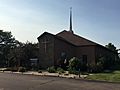
St. Paul's Lutheran Church

See also
 In Spanish: Cannon Falls (Minnesota) para niños
