
Cape May County, New Jersey facts for kids
Quick facts for kids
Cape May County
|
||
|---|---|---|

Sunset on the Cape May Peninsula at Sunset Beach
|
||
|
||

Location within the U.S. state of New Jersey
|
||
 New Jersey's location within the U.S. |
||
| Country | ||
| State | ||
| Founded | 1685 | |
| Named for | Cornelius Jacobsen Mey | |
| Seat | Cape May Court House (in Middle Township) | |
| Largest municipality | Lower Township (population) Middle Township (area) |
|
| Area | ||
| • Total | 620.42 sq mi (1,606.9 km2) | |
| • Land | 251.42 sq mi (651.2 km2) | |
| • Water | 368.99 sq mi (955.7 km2) 59.47% | |
| Population
(2020)
|
||
| • Total | 95,263 | |
| • Density | 378.9/sq mi (146.3/km2) | |
| Congressional district | 2nd | |

Cape May County is the southernmost county in the U.S. state of New Jersey. Much of the county is located on the Cape May Peninsula, bounded by the Delaware Bay to the west, and the Atlantic Ocean to the south and east. Adjacent to the Atlantic coastline are five barrier islands that have been built up as seaside resorts. A consistently popular summer destination with 30 miles (48 km) of beaches, Cape May County attracts vacationers from New Jersey and surrounding states, with the summer population exceeding 750,000. Tourism generates annual revenues of about $6.6 billion as of 2018, making it the county's single largest industry, with leisure and hospitality being Cape May's largest employment category. Its county seat is the Cape May Court House section of Middle Township.
As of the 2020 United States Census, the county's population was 95,263, making it the state's second-least populous county, a 2.1% decrease from the 97,265 enumerated at the 2010 census, in turn decreasing by 5,061 (-4.9%) from the 102,326 counted in the 2000 Census. The county is part of the Ocean City, NJ Metropolitan Statistical Area as well as the Philadelphia-Reading-Camden, PA-NJ-DE-MD Combined Statistical Area.
Before the county was settled by Europeans, the indigenous Kechemeche tribe of the Lenape people inhabited South Jersey. Beginning in 1609, European explorers purchased land from, and contributed to the decline of, the indigenous people. The county was named for Cornelius Jacobsen Mey, a Dutch captain who explored and charted the area from 1620 to 1621, and established a claim for the province of New Netherland. In 1685, the court of Cape May County was split from neighboring Burlington County, although the boundaries were not set until seven years later. In 1690, Cape May (originally known as Cape Island) was founded, becoming America's oldest seaside resort. The county was subdivided into three townships in 1798 – Lower, Middle, and Upper. The other 16 municipalities in the county, including two no longer in existence, were established between 1827 and 1928. In 1863, the first railroad in the county opened, which carried crops from the dominant farming industry. Railroads later led to the popularity of the coastal resorts in the county. Improved automotive access led to further development after the Garden State Parkway opened in 1956.
Contents
Geography
Most of the county lies on a peninsula that juts into Delaware Bay. It is flat and coastal. Sea level is the lowest point; the highest elevation is found at three areas in Belleplain State Forest in the county's northern corner which are approximately 60 feet (18 m) above sea level.
According to the 2010 Census, the county had a total area of 620.42 square miles (1,606.9 km2), including 251.42 square miles (651.2 km2) of land (40.5%) and 368.99 square miles (955.7 km2) of water (59.5%).
Adjacent counties
Cape May County borders the following counties:
- Atlantic County, New Jersey – north
- Cumberland County, New Jersey – northwest
- Kent County, Delaware - west¹
- Sussex County, Delaware - southwest¹
¹ across Delaware Bay; no land border
National protected area
Climate
Given its maritime influence and southernmost location within New Jersey, Cape May County has relatively mild wintertime temperatures, with very windy conditions more than half of the year, mostly in June and July. Conversely, the county witnesses lower summertime temperatures than most places in the state, making it a popular place to escape the heat as well. It is in USDA plant hardiness zone 7a/7b, Humid/Temperate. Its climate is suited to growing traditional Northeastern plants, including English Yew, Boxwoods and Sugar Maples. Because of the warmer wintertime temperatures, Hardy Palms, including Trachycarpus fortunei (Chinese Windmill Palm) and Needle Palms, would work quite well in the landscape, these plants having survived for many years also in other parts of coastal New Jersey, from Sandy Hook to Cape May. Wine grapes also do particularly well, given the long growing season. The wine industry is growing – four vineyards and wineries operate in the county now – three more are planted and on the way. The county had a once-vibrant lima bean industry that covered as much as 5,000 acres (2,000 ha) of land and West Cape May still calls itself the "lima bean capital of the world" and hosts an annual lima bean festival, though wine grapes are quickly becoming more common and many wineries dot the landscape.
According to the Köppen climate classification system, Cape May has a humid subtropical climate (Cfa) typical of New Jersey with warm, windy summers and cold winters.
The average temperatures in the county seat of Cape May Court House range from a low of 22 °F (−6 °C) in January to a high of 85 °F (29 °C) in July, although a record low of −22 °F (−30 °C) was recorded in January 1942 and a record high of 103 °F (39 °C) was recorded in July 1993. Average monthly precipitation ranged from 2.91 inches (74 mm) in June to 4.68 inches (119 mm) in August.
| Weather chart for Cape May Court House, New Jersey | |||||||||||||||||||||||||||||||||||||||||||||||
|---|---|---|---|---|---|---|---|---|---|---|---|---|---|---|---|---|---|---|---|---|---|---|---|---|---|---|---|---|---|---|---|---|---|---|---|---|---|---|---|---|---|---|---|---|---|---|---|
| J | F | M | A | M | J | J | A | S | O | N | D | ||||||||||||||||||||||||||||||||||||
|
3.5
42
22
|
3.1
45
24
|
4.5
53
30
|
4
64
39
|
3.7
73
47
|
2.9
80
58
|
4
85
64
|
4.7
82
62
|
4
77
54
|
3.9
66
43
|
3.6
57
34
|
3.4
46
26
|
||||||||||||||||||||||||||||||||||||
| temperatures in °F precipitation totals in inches source: The Weather Channel |
|||||||||||||||||||||||||||||||||||||||||||||||
|
Metric conversion
|
|||||||||||||||||||||||||||||||||||||||||||||||
Demographics
| Historical population | |||
|---|---|---|---|
| Census | Pop. | %± | |
| 1790 | 2,571 | — | |
| 1800 | 3,066 | 19.3% | |
| 1810 | 3,632 | 18.5% | |
| 1820 | 4,265 | 17.4% | |
| 1830 | 4,936 | 15.7% | |
| 1840 | 5,324 | 7.9% | |
| 1850 | 6,433 | 20.8% | |
| 1860 | 7,130 | 10.8% | |
| 1870 | 8,349 | 17.1% | |
| 1880 | 9,765 | 17.0% | |
| 1890 | 11,268 | 15.4% | |
| 1900 | 13,201 | 17.2% | |
| 1910 | 19,745 | 49.6% | |
| 1920 | 19,460 | −1.4% | |
| 1930 | 29,486 | 51.5% | |
| 1940 | 28,919 | −1.9% | |
| 1950 | 37,131 | 28.4% | |
| 1960 | 48,555 | 30.8% | |
| 1970 | 59,554 | 22.7% | |
| 1980 | 82,266 | 38.1% | |
| 1990 | 95,089 | 15.6% | |
| 2000 | 102,326 | 7.6% | |
| 2010 | 97,265 | −4.9% | |
| 2020 | 95,263 | −2.1% | |
| Historical sources: 1790-1990 1970-2010 2000 2010 2020 |
|||
2020 Census
As of the Census of 2020, the city had 95,263 people, 40,939 households, and 26,792 families. The population density was 378.9 inhabitants per square mile (146.3/km2). There were 99,606 housing units at an average density of 396.2 per square mile (153.0/km2). The city's racial makeup was 85.6% White, 3.74% African American, 0.26% Native American, 0.95% Asian, and 5.95% from two or more races. Hispanic or Latino of any race were 7.83% of the population.
There were 40,939 households, of which 23.8% had children under the age of 18 living with them, 52.7% were married couples living together, 26.3% had a female householder with no husband present, 15.5% had a male householder with no wife present and 34.5% were non-families. 15.1% of all households were made up of individuals, and 15.8% had someone living alone who was 65 years of age or older. The average household size was 2.19 and the average family size was 2.70.
About 17.6% of the city's population was under age 18, 6.7% was from age 18 to 24, 29.2% was from age 15 to 44, and 27.0% was age 65 or older. The median age was 50.5 years. The gender makeup of the city was 48.4% male and 51.5% female. For every 100 females, there were 94.0 males.
The city's median household income was $69,980, and the median family income was $83,695. About 8.8% of the population were below the poverty line, including 14.2% of those under age 18 and 6.2% of those age 65 or over.
Cape May County is part of the Ocean City, NJ Metropolitan Statistical Area, as well as the Philadelphia-Reading-Camden, PA-NJ-DE-MD Combined Statistical Area.
2010 census
As of the census of 2010, there were 97,265 people, 40,812 households, and 25,956 families residing in the county. The population density was 386.9 per square mile (149.4/km2). There were 98,309 housing units at an average density of 391 per square mile (151/km2)*. The racial makeup of the county was 89.83% (87,369) White, 4.69% (4,565) Black or African American, 0.21% (205) Native American, 0.86% (834) Asian, 0.04% (36) Pacific Islander, 2.47% (2,399) from other races, and 1.91% (1,857) from two or more races. [[Hispanic (U.S. Census)|Hispanic or Latino of any race were 6.22% (6,054) of the population.
There were 40,812 households out of which 21.6% had children under the age of 18 living with them, 48.3% were married couples living together, 11% had a female householder with no husband present, and 36.4% were non-families. 31.2% of all households were made up of individuals, and 15.5% had someone living alone who was 65 years of age or older. The average household size was 2.32 and the average family size was 2.89.
In the county, the population was spread out with 18.9% under the age of 18, 8% from 18 to 24, 20.1% from 25 to 44, 31.6% from 45 to 64, and 21.6% who were 65 years of age or older. The median age was 47.1 years. For every 100 females there were 94.6 males. For every 100 females ages 18 and old there were 92.4 males.
As of the 2010 Census, there were 98,365 houses in the county, of which only 42% were occupied year round. There are 47 campgrounds with 17,999 campsites, greater than the number of campsites in all other counties in the state combined. There are also 18,700 hotel rooms in the county. The median household income of the county was $57,168 as of 2013, the fourth-lowest of New Jersey's 21 counties. About 10% of residents live below the federal poverty line. The county ranked last in the state in terms of residents with Assets Limited, Income Constrained, and Employed (ALICE), representing nearly one-third of the county's residents.
Municipalities

Municipalities in Cape May County (with 2010 Census data for population, housing units and area; along with communities within each municipalities for which census designated places are noted with their population) are:
| Municipality (with map key) |
Municipal type |
Population | Housing Units |
Total Area |
Water Area |
Land Area |
Pop. Density |
Housing Density |
Communities |
|---|---|---|---|---|---|---|---|---|---|
| Avalon (9) | borough | 1,334 | 5,434 | 4.93 | 0.77 | 4.15 | 321.3 | 1,308.8 | |
| Cape May (3) | city | 3,607 | 4,155 | 2.74 | 0.34 | 2.40 | 1,500.6 | 1,728.5 | |
| Cape May Point (1) | borough | 291 | 619 | 0.31 | 0.02 | 0.30 | 984.5 | 2,094.2 | |
| Dennis Township (14) | township | 6,467 | 2,672 | 64.33 | 3.53 | 60.80 | 106.4 | 43.9 | Belleplain CDP (597) Clermont Dennisville Ocean View South Dennis South Seaville |
| Lower Township (16) | township | 22,866 | 14,507 | 31.01 | 3.27 | 27.74 | 824.3 | 523.0 | Diamond Beach CDP (136) Erma CDP (2,134) Miami Beach North Cape May CDP (3,226) Villas CDP (1,483) |
| Middle Township (15) | township | 18,911 | 9,296 | 82.96 | 12.62 | 70.33 | 268.9 | 132.2 | Burleigh CDP (725) Cape May Court House CDP (5,338) Dias Creek Goshen Green Creek Mayville Nummytown Rio Grande CDP (2,670) Swainton Whitesboro CDP (2,205) |
| North Wildwood (7) | city | 4,041 | 8,840 | 2.13 | 0.38 | 1.75 | 2,305.8 | 5,044.1 | |
| Ocean City (11) | city | 11,701 | 20,871 | 10.80 | 4.46 | 6.33 | 1,847.7 | 3,295.7 | |
| Sea Isle City (10) | city | 2,114 | 6,900 | 2.53 | 0.36 | 2.17 | 974.5 | 3,180.8 | |
| Stone Harbor (8) | borough | 866 | 3,247 | 1.96 | 0.56 | 1.40 | 619.6 | 2,323.3 | |
| Upper Township (13) | township | 12,373 | 6,341 | 68.69 | 6.54 | 62.15 | 199.1 | 102.0 | Beesley's Point Marmora Palermo Strathmere CDP (158) Tuckahoe |
| West Cape May (2) | borough | 1,024 | 1,043 | 1.18 | 0.01 | 1.17 | 878.8 | 895.1 | |
| West Wildwood (6) | borough | 603 | 893 | 0.35 | 0.07 | 0.28 | 2,188.4 | 3,240.9 | |
| Wildwood (5) | city | 5,325 | 6,843 | 1.39 | 0.09 | 1.30 | 4,082.0 | 5,245.7 | |
| Wildwood Crest (4) | borough | 3,270 | 5,569 | 1.31 | 0.18 | 1.13 | 2,884.0 | 4,911.6 | |
| Woodbine (12) | borough | 2,472 | 1,079 | 8.02 | 0.00 | 8.02 | 308.2 | 134.5 | |
| Cape May | county | 97,265 | 98,309 | 620.42 | 368.99 | 251.42 | 386.9 | 391.0 |
Transportation
The indigenous population left behind a series of trails across Cape May County by the late 17th century. In 1695, John Somers operated the first ferry service across the Great Egg Harbor Bay to Beesley's Point in Cape May County. Beginning in 1697 and completed in 1707, the residents of Cape May County financed the construction of a road running from Cape May to the ferry in Beesley's Point, and onward to Burlington. Roads were built across the county to connect with the court house, but in low-lying areas these routes were corduroy roads, built from a series of logs. Local businessmen built the Dennis Creek Causeway in 1803, which eventually became NJ 47, which contributed to the growth of towns along the Delaware Bay, although people traveled to the county more often by steamboat.
In August 1863, the Cape May and Millville Railroad opened, connecting the county more quickly to points to the northwest. The railroad shipped freight from the county's many farms, and brought more people to the area, contributing to the development of coastal resorts. Travelers often brought their lunch in shoe boxes, leading to their nickname "shoobies". By 1892, much of the county was accessible by railroad, including all of the barrier islands. A second rail line was added in 1893 that connected Cape May to a branch of the rail line that ran from Atlantic City to Camden. By the 1890s, bicycling became common throughout the county, and bikeriders successfully lobbied the county to build better roads. Between 1900 and 1915, the county government built over 100 miles of gravel roads, a fact promoted in a county promotional brochure, but also the cause of controversies. County engineer N. C. Price was dismissed in 1903 due to accusations of poor building materials and inflated costs, and in 1921, two freeholders were jailed for defrauding the county, resulting in a smaller board of freeholders.
In 1916, the New Jersey legislature created the state highway system, taking responsibility for the maintenance and building of major roads. In 1917, the road between Cape May and Seaville became Route 14, which was renumbered Route 4 in 1927, and later U.S. 9 by the 1940s. The road ran the length of the state, and connected Cape May County with Atlantic County via the Beesley's Point Bridge built in 1928. From 1934 to 1946, the Cape May County Bridge Commission issued bonds and secured funding for five toll bridges to connect the barrier islands with each other. By the 1950s, state routes 47, 49, 50, 52, and 83 were established, connecting various municipalities.
In 1956, the Great Egg Harbor Bridge opened, connecting the county with Atlantic County and points north and west via the Garden State Parkway. A parallel bridge carrying northbound traffic of the Garden State Parkway opened in 1973. The road brings hundreds of thousands of people to the county during the summertime. The parkway passes through the length of the county, and has its southern terminus, known as Exit Zero, in Lower Township, connecting with U.S. Route 9. Further transportation connections were made after the Cape May–Lewes Ferry began operation in 1964, which can carry up to 100 cars and 800 people on its fleet of five boats. In 1971, Route 147 replaced county routes for the roadway from North Wildwood to U.S. 9, and in the same year, Route 162 was established for a new bridge over the Cape May Canal. In 1972, U.S. 9 was relocated from its southern terminus in Cape May to the ferry; the former route was redesignated Route 109. Route 347 was designated in the 1990s as an alternate route to Route 47.
The county has a total of 1,036.15 miles (1,667.52 km) of roadways, of which 730.07 miles (1,174.93 km) are maintained by the local municipality, 200.98 miles (323.45 km) by Cape May County, 74.18 miles (119.38 km) by the New Jersey Department of Transportation and 30.92 miles (49.76 km) by the New Jersey Turnpike Authority. There are 23 bridges owned by the county, including a series of causeways and bridges connecting the five barrier islands to the mainland.
There is limited public transportation within the county. The ensuing traffic congestion during summer months causes roadway congestion. NJ Transit buses operate the following lines in and out of the county: 313, 315, 316, 319, 507, 509, 510, and 552. The Great American Trolley Company operates private trolleys in Cape May, the Wildwoods, and Ocean City. The county also has a Fare Free Transportation system for limited populations. There are three airports in the county. The oldest is Ocean City Municipal Airport, opened in 1937. In 1941, Cape May Airport opened about 5 mi (8.0 km) north of Cape May, originally as Naval Air Station Wildwood. Woodbine Municipal Airport opened in 1945.
In 2009, the Ocean City metropolitan statistical area (MSA) ranked as the sixth highest in the United States for percentage of commuters who walked to work (8.4%).
Economy
The primary job sectors in Cape May County are related to hotel accommodation, food service, retail, health care/aide, arts/entertainment, and construction. Historically, Cape May County's economy was driven by whaling and farming, until seasonal resorts were built in the 19th century. These industries remain a part of the county's job sector, along with agritourism, and around 30,000 people in the private industry. The largest employer is Morey's Piers, which hires 1,500 people. Cape Regional Medical Center hires over 1,000 people. More than 10,000 people are in the hospitality sector. As of February 2018, the unemployment rate in Cape May County was 14.3%, significantly more than the 5.2% unemployment rate in August 2017. Each year, the unemployment rate peaks in the wintertime and drops in the summertime, reflective of the county's dependence on seasonal tourism-driven jobs. As of February 2018, Cape May County had the highest unemployment rate in New Jersey, followed by neighboring Atlantic and Cumberland counties.
Based on data from the Bureau of Economic Analysis, Cape May County had a gross domestic product (GDP) of $4.9 billion in 2018, which was ranked 19th in the state and represented an increase of 2.0% from the previous year.
As of 2018, the tourism industry generated about $6.6 billion worth of income in Cape May County, representing 43% of county employment. Retail, food, and beverage represented $2.6 billion, while camping and lodging represented about $2.4 billion in expenditures. Recreational activities generated $708 million in expenditures. Eco-tourism generated $670 million, and transportation costs were $390 million. There is little heavy industry in the county due to environmental concerns.
Tourism

The majority of Cape May County's industry is tourism, due to its beaches and location between the Delaware Bay and the Atlantic Ocean. During the summer season (which traditionally ranges from Memorial Day to Labor Day), tourists often outnumber locals 9 to 1. As of 2010, the four largest markets for tourism in Cape May County were Greater Philadelphia, North Jersey, New York, and the Canadian province of Québec.
In addition to sales tax, hotel occupancy tax and other assessments charged throughout the state, tourism-related business in North Wildwood, Wildwood and Wildwood Crest, such as hotels and restaurants, are required to collect an additional 2% tourism sales tax that is used to cover costs for promoting tourism.
Canadian tourists typically visit Cape May County over the summer. In 1991, Canadian tourism into Cape May County remained strong despite an economic recession occurring in Canada. As of 1993, most Canadian tourists to the county were Francophones, who typically began their visits during the final two weeks of the month of July, when many Canadians working in the construction and garment sectors receive two-week paid time off. Most of the French Canadian tourists who visit Cape May County stay in hotels in The Wildwoods or campgrounds on the mainland. In the 1990s, Cape May County established its first international tourism office in Montréal, along St. Catherine's Street, but closed it around 1995, due to budget cuts. By 2010 the tourism office of Cape May County established a French language coupon booklet. In 2010, Cape May County tourism director estimated that 13% of visitors to the region originated from Quebec.
Beach tags are required for beach access in some of the most popular beaches and are collected under the terms of a 1955 state law that allows oceanfront municipalities to charge "reasonable fees" for providing safety and maintenance at the beaches. The highest seasonal beach tag fee in the county was $35. The sale of daily, weekly and seasonal tags is a major source of revenue for the communities, with the six beachfront communities in Cape May County that charge for beach tags generating $10 million in revenue in 2016. Ocean City brought in $4.1 million in revenue in the 2016 season, the most of any municipality in the state. In the 2017 budget, the projected $4.1 million in fees for beach tag and $3 million for parking were two of Ocean City's biggest revenue sources, accounting for almost 9% of the city's annual budget of almost $80 million. Cape May City, with revenue of $2.2 million, was ranked third in the state. Four of the five municipalities in the state with guarded oceanfront beaches available with free public access are in the county, including Strathmere in Upper Township and the Wildwoods communities of North Wildwood, Wildwood and Wildwood Crest.
Beginning in 1968 the county government began campaigns to attract tourists from Canada. In 1970 it established a tourism office in Montreal and later made strides to get tourists from other parts of Quebec. The county government made efforts to train tourism establishments on how to receive French-speaking Canadian tourists.
Fishing and farming
Fishing has been an important industry in Cape May County since at least the 17th century, when the county's first European settlement was founded as a whaling village. In 1693, whaling proved such a successful industry that colonial Governor Andrew Hamilton instituted a 10% tax on whale products. By the mid-1700s, overfishing had diminished the whale population in the region. In the early 1800s, shipbuilding was an important industry, which declined by the 1850s. Fishing remains an important aspect of Cape May County's economy. In 2016, the combined port of Cape May and Wildwood ranked the ninth largest commercial fishing port in the United States as measured by monetary value, as well as the second largest on the east coast, only after New Bedford. Fishermen brought in 47 million lbs (21 million kg) of seafood, mainly scallops, worth $85 million (2016 USD). This was up from $73.7 million in 2009, when the overall market value of the port was estimated at $442 million, making it the fourth most valuable port in the country. In the 1980s, the scallop industry was worth only $15 million in the state of New Jersey. In 1990, laws limiting the catch and area of scallops led to a healthier and steadier population to harvest, which allowed for growth in the industry. Cold Spring Fish and Supply Company provides 500 jobs and is the county's third-largest employer.
Farming became an important industry in the county by the 19th century, when nearly 70,000 acres (28,000 ha), or about 40% of the county's land area, was involved in farming. The industry's popularity led to the first freight railroad in 1863, and continued to be a fixture of the county's economy until the 1960s. There is an annual lima bean festival in West Cape May featuring foods made with the locally grown lima beans.
Breweries, distilleries, and wineries
Cape May Brewing Company opened in 2011 at the Cape May Airport, and by 2015 was the third-largest brewer in New Jersey. Tuckahoe Brewing also opened in 2011 in Ocean View, but moved to a bigger facility in Egg Harbor Township in neighboring Atlantic County in 2015. In 2015, Slack Tide Brew opened in Clermont. In 2016, Ludlam Island Brewery opened in the former location of Tuckahoe Brewing, after originally seeking to open the facility in Sea Isle City. Also in 2016, Cold Spring Brewing began operations out of a barn from 1804, as part of Historic Cold Spring Village, and 7 Mile Brewery opened in Cape May Court House. In 2017, Avalon Brew Pub opened in Avalon, and Bucket Brigade Brewery opened in Cape May Court House. Mudhen Brewery opened in Wildwood in April 2018. Gusto Brewery opened in December 2018 in North Cape May.
The first distillery to open in the county since the prohibition era was Lazy Eye Distillery, which opened a second facility in Wildwood in 2015 after opening its first facility in Atlantic County in 2014. In the same year, Cape May Distillery opened in Green Creek. In 2017, Nauti Spirits opened in Cape May on a 60 acres (24 ha) farm.
In 2007, the New Jersey Department of Agriculture designated Atlantic, Cape May, Cumberland, and Ocean counties as the Outer Coastal Plain American Viticultural Area (AVA) in 2007, recognizing the area as well-suited for grape growing. In late 2014, local wineries sought for a distinct Cape May Peninsula AVA. As of 2015, there were six wineries in the county. Cape May Winery & Vineyard opened in 1995 in North Cape May as the first commercial winery in the county. Turdo Vineyards & Winery opened to the public in North Cape May in 2004. Natali Vineyards opened in 2007 in the Goshen section of Middle Township. In 2009, Hawk Haven Vineyard & Winery opened to the public in the Rio Grande section of Lower Township. In 2012, Jessie Creek Winery opened in Cape May Court House, and in the same year, Willow Creek Winery opened in West Cape May.
Images for kids
-
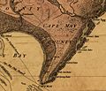
Detail of a 1777 map depicting Cape May County. The area shown was the scene of military activity, the Battle of Turtle Gut Inlet, early in the American Revolutionary War.
-
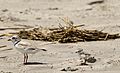
Piping plovers in Cape May
-
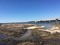
View from Corson's Inlet State Park, created to preserve one of the last undeveloped areas of land along the Jersey Shore.
-

A demoiselle crane (Anthropoides virgo) at Cape May Zoo

.jpg)

.jpg)
See also
 In Spanish: Condado de Cape May para niños
