
Cape Northumberland (South Australia) facts for kids
Quick facts for kids Cape NorthumberlandPort MacDonnell, South Australia |
|
|---|---|

Cape Northumberland, from the west
|
|

Cape Northumberland
Location in South Australia
|
|
| Elevation | 30 m (98 ft) |
| Location |
|
| Footnotes | Locations |
Cape Northumberland is a headland in the southeast of the Australian state of South Australia. It is the southernmost point of South Australia. It is located about 3 kilometres (1.9 mi) from the town of Port MacDonnell, 28 kilometres south southwest from the municipal seat of Mount Gambier and about 393 kilometres (244 mi) southeast of the state's capital Adelaide.
History
Cape Northumberland was named by the Royal Navy officer, James Grant, on 3 December 1800, when he was mapping the southern coast of Australia in his early 1800s expedition. The headland was named after Hugh Percy, Duke of Northumberland. The cape is near the site of the historic Cape Northumberland Lighthouse, which was originally built in 1887. A new lighthouse has been built about 700 metres (2,300 ft) north of Cape Northumberland.
Geography
The cape is located on the southeast coast of South Australia. It is the western end of Discovery Bay and its subsidiary, MacDonnell Bay. The cape was described in 2017 in an American source as being "about 30 metres (98 ft) high, is rugged and cliffy, with a hill rising to an elevation of 41 metres (135 ft) behind it. It is the southernmost point on the South Australian coastline.
Gallery
-
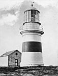
The first Cape Northumberland Lighthouse
-
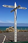
The sign at Cape Northumberland, marking South Australia's southernmost point
-
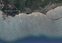
A satellite image of Cape Northumberland (left) showing its relationship to the coastline to its immediate east including the James Corcoran Breakwater


