Carroll County, Iowa facts for kids
Quick facts for kids
Carroll County
|
|
|---|---|

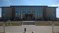
Carroll County Courthouse
|
|

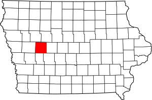
Location within the U.S. state of Iowa
|
|
 Iowa's location within the U.S. |
|
| Country | |
| State | |
| Founded | 1851 |
| Named for | Charles Carroll of Carrollton |
| Seat | Carroll |
| Largest city | Carroll |
| Area | |
| • Total | 570 sq mi (1,500 km2) |
| • Land | 569 sq mi (1,470 km2) |
| • Water | 0.8 sq mi (2 km2) 0.1% |
| Population
(2020)
|
|
| • Total | 20,760 |
| • Density | 36.4/sq mi (14.06/km2) |
| Time zone | UTC−6 (Central) |
| • Summer (DST) | UTC−5 (CDT) |
| Congressional district | 4th |
Carroll County is a county located in the U.S. state of Iowa. As of the 2020 census, the population was 20,760. Its county seat is Carroll. The county is named in honor of Charles Carroll of Carrollton, signer of the Declaration of Independence.
Contents
History
Carroll County was formed on January 15, 1851 from sections of Pottawattamie County. It was named after Charles Carroll of Carrollton, Maryland, the only Roman Catholic and longest-living signer of the Declaration of Independence. In 1855, the county government was established in Carrolton and in 1858, the first courthouse was built. In 1869, the seat was moved to Carroll City (today Carroll) which was centrally located and connected to the Chicago and North Western Transportation Company. The courthouse was destroyed in 1886 by fire. The present courthouse was erected in 1965. However the courthouse is set to go under construction in the near future
Geography
According to the U.S. Census Bureau, the county has a total area of 570 square miles (1,500 km2), of which 569 square miles (1,470 km2) is land and 0.8 square miles (2.1 km2) (0.1%) is water.
Major highways
Adjacent counties
- Sac County (northwest)
- Calhoun County (northeast)
- Greene County (east)
- Guthrie County (southeast)
- Audubon County (south)
- Crawford County (west)
Demographics
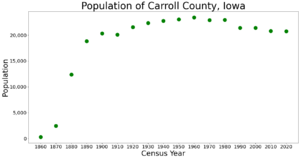
| Historical population | |||
|---|---|---|---|
| Census | Pop. | %± | |
| 1860 | 281 | — | |
| 1870 | 2,451 | 772.2% | |
| 1880 | 12,351 | 403.9% | |
| 1890 | 18,825 | 52.4% | |
| 1900 | 20,319 | 7.9% | |
| 1910 | 20,117 | −1.0% | |
| 1920 | 21,549 | 7.1% | |
| 1930 | 22,326 | 3.6% | |
| 1940 | 22,770 | 2.0% | |
| 1950 | 23,065 | 1.3% | |
| 1960 | 23,431 | 1.6% | |
| 1970 | 22,912 | −2.2% | |
| 1980 | 22,951 | 0.2% | |
| 1990 | 21,423 | −6.7% | |
| 2000 | 21,421 | 0.0% | |
| 2010 | 20,816 | −2.8% | |
| 2020 | 20,760 | −0.3% | |
| U.S. Decennial Census 1790-1960 1900-1990 1990-2000 2010-2018 |
|||
2020 census
The 2020 census recorded a population of 20,760 in the county, with a population density of 35.845/sq mi (13.840/km2). 97.14% of the population reported being of one race. 91.28% were non-Hispanic White, 1.26% were Black, 2.86% were Hispanic, 0.15% were Native American, 0.36% were Asian, 0.00% were Native Hawaiian or Pacific Islander and 4.08% were some other race or more than one race. There were 9,490 housing units of which 8,764 were occupied.
2010 census
The 2010 census recorded a population of 20,816 in the county, with a population density of 36.58/sq mi (14.12/km2). There were 9,376 housing units, of which 8,683 were occupied.
Communities
Townships
Carroll County is divided into sixteen townships:
- Arcadia
- Eden
- Ewoldt
- Glidden
- Grant
- Jasper
- Kniest
- Maple River
- Newton
- Pleasant Valley
- Richland
- Roselle
- Sheridan
- Union
- Washington
- Wheatland
Population ranking
The population ranking of the following table is based on the 2010 census of Carroll County.
† county seat
| Rank | City/Town/etc. | Municipal type | Population (2010 Census) |
|---|---|---|---|
| 1 | † Carroll | City | 10,103 |
| 2 | Manning | City | 1,500 |
| 3 | Coon Rapids (partially in Guthrie County) | City | 1,305 |
| 4 | Glidden | City | 1,146 |
| 5 | Arcadia | City | 484 |
| 6 | Breda | City | 483 |
| 7 | Templeton | City | 362 |
| 8 | Dedham | City | 266 |
| 9 | Halbur | City | 246 |
| 10 | Lidderdale | City | 180 |
| 11 | Lanesboro | City | 121 |
| 12 | Willey | City | 88 |
| 13 | Ralston (partially in Greene County) | City | 79 |
See also
 In Spanish: Condado de Carroll (Iowa) para niños


