
Castle Peak (Alaska) facts for kids
Quick facts for kids Castle Peak |
|
|---|---|

Aerial view of south aspect
|
|
| Highest point | |
| Elevation | 10,190 ft (3,110 m) |
| Prominence | 2,200 ft (670 m) |
| Isolation | 4.49 mi (7.23 km) |
| Parent peak | Mount Blackburn |
| Geography | |

Castle Peak
Location in Alaska
|
|
| Location | Wrangell-St. Elias National Park Valdez-Cordova Borough Alaska, United States |
| Parent range | Wrangell Mountains |
| Topo map | USGS McCarthy C-7 |
Castle Peak is a 10,190-foot (3110 meter) mountain summit located in the Wrangell Mountains, in the U.S. state of Alaska. The peak is situated in Wrangell-St. Elias National Park and Preserve, 21 mi (34 km) northwest of McCarthy, and 9.3 mi (15 km) south of Mount Blackburn on the south margin of the Kuskulana Glacier valley. Precipitation runoff from the mountain drains into Kuskulana River and Lakina River which are both tributaries of the Chitina River. The peak's descriptive name was used by early prospectors as reported in 1901 by the US Geological Survey.
Climate
Based on the Köppen climate classification, Castle Peak is located in a subarctic climate zone with long, cold, snowy winters, and cool summers. Winds coming off the Gulf of Alaska are forced upwards by the Wrangell Mountains (orographic lift), causing precipitation in the form of rainfall and snowfall. Temperatures can drop below −20 °F with wind chill factors below −30 °F. The months May through June offer the most favorable weather for viewing and climbing.
Images for kids
-
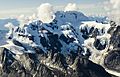
Castle Peak, north aspect
-
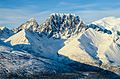
Castle Peak, south aspect
-
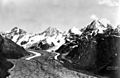
Castle Peak (right), with Kuskulana Glacier. 1924


.jpg)
