
Castle Rock, Colorado facts for kids
Quick facts for kids
Castle Rock, Colorado
|
|
|---|---|

Looking down Wilcox Street in Castle Rock
|
|

Location of the Town of Castle Rock in Douglas County, Colorado
|
|

Castle Rock, Colorado
Location in the United States
|
|
| Country | |
| State | |
| County | Douglas County seat |
| Founded | 1874 |
| Incorporated (town) | April 14, 1881 |
| Government | |
| • Type | Home rule municipality |
| Area | |
| • Total | 34.290 sq mi (88.811 km2) |
| • Land | 34.290 sq mi (88.811 km2) |
| • Water | 0 sq mi (0.000 km2) |
| Elevation | 6,224 ft (1,897 m) |
| Population
(2020)
|
|
| • Total | 73,158 |
| • Density | 2,134/sq mi (824/km2) |
| • Metro | 2,963,821 (19th) |
| • CSA | 3,623,560 (17th) |
| • Front Range | 5,055,344 |
| Time zone | UTC−07:00 (MST) |
| • Summer (DST) | UTC−06:00 (MDT) |
| ZIP Codes |
80104, 80108, 80109
|
| Area code(s) | 303 & 720 |
| FIPS code | 08-12415 |
| Major Routes | |
Castle Rock is a home rule town that is the county seat and the most populous municipality of Douglas County, Colorado, United States. The town population was 73,158 at the 2020 United States Census, a 51.68% increase since the 2010 United States Census. Castle Rock is the most populous Colorado town (rather than city) and the 16th most populous Colorado municipality. Castle Rock is a part of the Denver-Aurora-Lakewood, CO Metropolitan Statistical Area and the Front Range Urban Corridor.
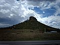
The town is named for the prominent, castle-shaped butte near the center of town.
Contents
History

The region in and around Castle Rock was originally home to the Arapaho and Cheyenne people. They occupied the land between the Arkansas and South Platte Rivers.
White settlers were drawn to the area by rumors of gold and by land opened through the Homestead Act of 1862. However, it was the discovery of rhyolite stone, not gold, that ultimately led to the settlement of Castle Rock.
Castle Rock was founded in 1874 when the eastern Douglas County border was redrawn to its present location. Castle Rock was chosen as the county seat because of its central location.
One of the first homesteaders in the area near today's Castle Rock was Jeremiah Gould. He owned about 160 acres (0.65 km2) to the south of "The (Castle) Rock." At that time, the settlement consisted of just a few buildings for prospectors, workers, and cowboys. In 1874, Jeremiah Gould donated 120 acres (0.49 km2) to the new town that was also now home to the Douglas County government. For the beginning the six streets named Elbert, Jerry, Wilcox, Perry, Castle and Front were laid out to build the actual town of Castle Rock. The Courthouse Square was defined and about 77 lots, each 50 by 112 feet (34 m), were auctioned off for a total profit of US$3,400.
A new train depot brought the Denver and Rio Grande Railway to the area.
During the late 1800s and early 1900s, Castle Rock had a very active Rhyolite quarrying industry. Many Swedish immigrants arrived in the area to work in the quarries.
Castle Rock currently encompasses about 35 square miles (91 km2), with a population of more than 42,000 in town and 70,000 in the surrounding area.
Geography

Castle Rock is located at 39°22′20″N 104°51′22″W / 39.37222°N 104.85611°W (39.372212, -104.856090) at an elevation of 6,224 feet (1,897 m). Located in central Colorado at the junction of Interstate 25 and State Highway 86, Castle Rock is 28 mi (45 km) south of downtown Denver and 37 mi (60 km) north of Colorado Springs.
The town lies a few miles east of the Rampart Range of the Rocky Mountains on the western edge of the Great Plains. Castle Rock, the butte that is the town's namesake, sits just north of the town center. Other prominent landforms visible from Castle Rock include Dawson Butte, Devils Head, Mount Evans and Pikes Peak.
East Plum Creek, a stream within the South Platte River watershed, flows generally north through Castle Rock. Hangman's Gulch, which runs northwest then west around the north side of the town center, drains into East Plum Creek as do multiple unnamed gulches in the southern and western areas of town. McMurdo Gulch and Mitchell Gulch run north then northeast through eastern Castle Rock and drain into Cherry Creek east of town.
Castle Rock is within the Colorado Foothills Life Zone.
According to the United States Census Bureau, Castle Rock has a total area of 33.79 square miles (87.5 km2), all of it land.
Lying within the Front Range Urban Corridor, the town is part of the greater Denver metropolitan area. Castle Rock borders three communities, all to its north; from west to east, these are Castle Pines Village, the city of Castle Pines, and The Pinery. Other nearby communities include Franktown to the east, Larkspur to the south, Perry Park to the southwest, and Sedalia to the northwest.
Climate
Castle Rock experiences a semi-arid climate (Köppen BSk) with cold, dry, snowy winters and hot, wetter summers. On average, the town receives 18.79 inches (477 mm) of precipitation annually. Snowfall averages 61.8 inches (157 cm) per year. On average, January is the coldest month, July is the hottest month, and August is the month with the most precipitation. The hottest temperature recorded in Castle Rock was 99 °F (37 °C) in July 1973; the coldest temperature recorded was −35 °F (−37 °C) in January 1963.
| Climate data for Castle Rock, Colorado | |||||||||||||
|---|---|---|---|---|---|---|---|---|---|---|---|---|---|
| Month | Jan | Feb | Mar | Apr | May | Jun | Jul | Aug | Sep | Oct | Nov | Dec | Year |
| Record high °F (°C) | 73 (23) |
75 (24) |
80 (27) |
91 (33) |
94 (34) |
98 (37) |
99 (37) |
98 (37) |
94 (34) |
91 (33) |
78 (26) |
71 (22) |
99 (37) |
| Average high °F (°C) | 45.5 (7.5) |
46.4 (8.0) |
52.6 (11.4) |
59.2 (15.1) |
69.0 (20.6) |
79.0 (26.1) |
85.2 (29.6) |
82.7 (28.2) |
75.6 (24.2) |
64.6 (18.1) |
53.2 (11.8) |
44.7 (7.1) |
63.1 (17.3) |
| Daily mean °F (°C) | 31.7 (−0.2) |
33.0 (0.6) |
39.4 (4.1) |
46.0 (7.8) |
55.5 (13.1) |
64.6 (18.1) |
70.4 (21.3) |
68.6 (20.3) |
60.7 (15.9) |
49.6 (9.8) |
39.1 (3.9) |
31.2 (−0.4) |
49.2 (9.5) |
| Average low °F (°C) | 17.8 (−7.9) |
19.7 (−6.8) |
26.2 (−3.2) |
32.7 (0.4) |
42.0 (5.6) |
50.3 (10.2) |
55.7 (13.2) |
54.4 (12.4) |
45.8 (7.7) |
34.6 (1.4) |
24.9 (−3.9) |
17.6 (−8.0) |
35.1 (1.8) |
| Record low °F (°C) | −35 (−37) |
−29 (−34) |
−14 (−26) |
−7 (−22) |
18 (−8) |
28 (−2) |
39 (4) |
35 (2) |
15 (−9) |
−3 (−19) |
−18 (−28) |
−26 (−32) |
−35 (−37) |
| Average precipitation inches (mm) | 0.62 (16) |
0.65 (17) |
1.83 (46) |
2.20 (56) |
2.18 (55) |
2.05 (52) |
2.46 (62) |
2.71 (69) |
1.24 (31) |
1.11 (28) |
1.00 (25) |
0.74 (19) |
18.79 (476) |
| Average snowfall inches (cm) | 8.2 (21) |
7.2 (18) |
14.7 (37) |
9.2 (23) |
0.7 (1.8) |
0 (0) |
0 (0) |
0 (0) |
0.3 (0.76) |
3.5 (8.9) |
7.0 (18) |
11.0 (28) |
61.8 (156.46) |
| Average precipitation days (≥ 0.01 in) | 3.5 | 3.8 | 5.3 | 5.7 | 7.9 | 7.6 | 7.4 | 9.4 | 5.8 | 3.8 | 3.8 | 3.9 | 67.8 |
| Average snowy days (≥ 0.1 in) | 3.1 | 3.5 | 3.9 | 3.1 | 0.4 | 0 | 0 | 0 | 0.3 | 1.1 | 2.9 | 3.7 | 21.9 |
| Source: National Weather Service; The Weather Channel | |||||||||||||
Neighborhoods
Castle Rock's postal codes include many neighborhoods:
Meadows, Founders and Crystal Valley Ranch
Map of Neighborhoods in the Meadows Castle Rock
|
North of Downtown / West of I-25
South of Downtown / West of I-25
|
North of Downtown / East of I-25
South of Downtown / East of I-25
|
Link to a Map of the Neighborhoods in Castle Rock, Colorado
Demographics
| Historical population | |||
|---|---|---|---|
| Census | Pop. | %± | |
| 1880 | 88 | — | |
| 1890 | 315 | 258.0% | |
| 1900 | 304 | −3.5% | |
| 1910 | 365 | 20.1% | |
| 1920 | 461 | 26.3% | |
| 1930 | 478 | 3.7% | |
| 1940 | 580 | 21.3% | |
| 1950 | 741 | 27.8% | |
| 1960 | 1,152 | 55.5% | |
| 1970 | 1,531 | 32.9% | |
| 1980 | 3,921 | 156.1% | |
| 1990 | 8,708 | 122.1% | |
| 2000 | 20,224 | 132.2% | |
| 2010 | 48,231 | 138.5% | |
| 2020 | 73,158 | 51.7% | |
| U.S. Decennial Census | |||
As of the 2010 census, there were 48,231 people, 16,688 households, and 12,974 families residing in the town. The population density was 1,526.3 people per square mile (589.3/km2). There were 17,626 housing units at an average density of 557.8 per square mile (215.2/km2). The racial makeup of the town was 90.7% White, 1.7% Asian, 1.1% African American, 0.6% American Indian, 0.1% Pacific Islander, 2.9% from other races, and 2.8% from two or more races. Hispanics and Latinos of any race were 10.0% of the population.<
There were 16,688 households, out of which 48.4% had children under the age of 18 living with them, 65.4% were married couples living together, 3.9% had a male householder with no wife present, 8.5% had a female householder with no husband present, and 22.3% were non-families. 17.7% of all households were made up of individuals, and 4.0% had someone living alone who was 65 years of age or older. The average household size was 2.86, and the average family size was 3.27.
In the town, the population was spread out, with 32.4% under the age of 18, 5.8% from 18 to 24, 33.0% from 25 to 44, 22.6% from 45 to 64, and 6.2% who were 65 years of age or older. The median age was 33.8 years. For every 100 females, there were 98.5 males. For every 100 females age 18 and over, there were 95.5 males age 18 and over.
The median income for a household in the town was $85,461, and the median income for a family was $95,973. Males had a median income of $66,993 versus $47,087 for females. The per capita income for the town was $34,089. About 4.0% of families and 6.2% of the population were below the poverty line, including 8.2% of those under age 18 and 6.2% of those age 65 or over.
Castle Rock is the 17th most populous municipality in Colorado and is the center of the burgeoning urbanization of the county.
Parks and recreation
Castle Rock's open space and parks comprise 27% the town’s total land area (5,415 acres (21.91 km2) of parks and open space / 20,224 acres (81.84 km2) total land area). Additionally, there are nearly 75 miles (121 km) of soft-surface and paved trails.
- Parks - Baldwin Park, Bison Park, Butterfield Park, Castle Highlands Park, Castle North Park, Castlewood Canyon State Park, Centennial Park, Festival Park, Founders Park, Gemstone Park, Glovers Tot Lot, Matney Park, Metzler Ranch Park, Mitchell Gulch Park, Paintbrush Park, Plum Creek Park, Rhyolite Regional Park, Rosecrown Park.
- Trails & Open Space - East Plum Creek Trail, Gateway Mesa Open Space, Hidden Mesa Open Space, Memmen Ridge Open Space, Mitchell Creek Canyon Trail, Mitchell Creek Trail System, Native Legend Open Space, Quarry Mesa Open Space, Ridgeline Open Space, Rock Park, The Bowl.
Culture

Points of interest
The Castle Rock Historical Museum is located in the former Denver and Rio Grande Railway depot building on Elbert Street. This building is purported to have been built in 1875. It is made of rhyolite taken from local quarries. In this museum visitors can see history of how Castle Rock changed over the years.
The Sri Venkateswara Temple's 8 acre complex located on Ridge Road is a significant landmark for the Hindu community of Colorado, attracting regular worshipers from as far away as Colorado Springs and Denver. The Temple also invites Swami's to lecture, offers classes, and undertakes outreach and service programs in the community.
Sports
From 1986 through 2006, a professional golf tournament was held in Castle Pines Village. The International, a PGA Tour event, was held in August at the Castle Pines Golf Club.
In the media
In the 2000s, Castle Rock developed a positive reputation in American media as an affordable and family-friendly community:
- In 2014, Money magazine ranked Castle Rock No. 4 in the nation in its list of the “Best Places to Live 2014". "Our reporters then visit 35 of the top ranking places to choose a top 10 that not only look good on paper, but also have happy residents, manageable traffic, attractive parks and gathering places, plus intangibles like community spirit. "
- Money magazine ranked Castle Rock No. 19 in the nation in 2011 and No. 16 in 2012 its list of the “100 Best Places to Live in America". Ranking methodology was based on job growth, home affordability, safety, school quality, health care, arts and leisure, diversity and several ease-of-living criteria.
- Family Circle magazine ranked Castle Rock No. 1 in the nation in its list of the “10 Best Towns for Families," August 2010. The article shares the results of the magazine’s quest to identify "the best communities across the country that combine big-city opportunities with suburban charm" and "an ideal blend of affordable houses, good jobs, top-rated schools, wide-open spaces and a lot less stress." This is Castle Rock's second time making Family Circle's top ten list. In the August 2007 issue Castle Rock was ranked No. 9.
- Forbes magazine named Castle Rock No. 5 of “America's 25 Best Places To Move,” 7 July 2009
- Money magazine ranked Douglas County No. 5 in the United States for “Job Growth over the Last Eight Years”. (Towns include Castle Rock, Parker, Stonegate, Lone Tree, and Highlands Ranch), 18 August 2009
- American City Business Journals (ACBJ) ranked Douglas County No. 4 in the nation for “Quality of Life,” May 2004
- Denver Business Journal reported that Castle Rock was ranked No. 6 on Gadberry Group’s list of "2008 High-Growth Areas in the United States". 9 January 2009
Gallery
-
View of Pikes Peak from Rock Park in Castle Rock.
-
View of Devil's Head Lookout from Ridgeline Open Space in Castle Rock.
-
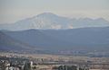
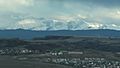
View of Mount Evans from Rock Park in Castle Rock.
-
View from Rock Park Lookout Area in Castle Rock.
-
View of Pikes Peak from I-25 in Castle Rock.
-
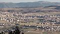
View of The Meadows neighborhood taken from Daniels Park.
-
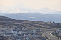
Castle Rock as seen from I-25.
-
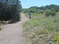
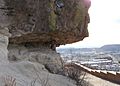
Hiking trail at Rock Park in Castle Rock.


Economy
Because of its Front Range location between Denver and its inner suburbs and Colorado Springs, many of Castle Rock's residents commute nearly 20 miles to northern Colorado Springs or the Denver Technological Center, better known as "The Denver Tech Center" (DTC), which is an 18-mile drive north on I-25, with Downtown Denver roughly 30 miles north, and Denver International Airport about 45 miles north.
In fact, about 80% of Castle Rock residents commute out of town to work. The average one-way commute time for a Castle Rock resident is about 29 minutes, longer than the U.S. average.
One reason for this is that the town has not yet attracted the variety or extent of employers needed to significantly lower the number of commuters to work outside Castle Rock. The town has relatively little land zoned for industrial or light industrial use, with the vast majority of the land within town limits dedicated to residential construction only.
As of 2011, 78.2% of the population over the age of 16 was in the labor force, 0.4% was in the armed forces, and 77.7% was in the civilian labor force, with 72.6% employed and 5.1% unemployed. The employed civilian labor force was 48.0% in management, business, science, and arts; 25.8% in sales and office occupations; 14.7% in service occupations; 6.4% in natural resources, construction, and maintenance; and 5.2% in production, transportation, and material moving. The three industries employing the largest proportion of the working civilian labor force were educational services, health care, and social assistance (15.5%); professional, scientific, and management, and administrative and waste management services (13.2%); and finance and insurance, and real estate and rental and leasing (12.6%).
Castle Rock's cost of living is above average. Compared to a U.S. average of 100, the cost of living index for the town is 137.2.
As of mid-2019, the median home value in the town was $427,537. The median gross monthly rent for an apartment was about $1,461.
The town's housing base continues to grow. About 1,400 permits to build new homes were issued in 2018.
Education
Primary and secondary education
Douglas County School District is based in Castle Rock and operates 18 public schools in the town. These include ten elementary schools, two middle schools, two charter schools, one magnet school, one alternative high school, and two high schools: Castle View High School and Douglas County High School. In addition, there are three private primary schools in Castle Rock.
School board elections in Douglas County are held in odd-numbered years. In recent years the community has experienced a spirited debate between supporters of significant change in the management of local schools and those who oppose such changes or believe they should advance at a slower pace.
Libraries
The Douglas County Libraries public library system is based in Castle Rock, co-located with the local branch library, the Philip S. Miller Library, south of downtown. The Miller Library includes the Douglas County History Research Center and offers several educational and recreational programs to the public. Also, it includes Little Free Librarys places scattered throughout, such as in festival park.
Infrastructure
Transportation
Interstate 25 and U.S. Route 87 run concurrently north-south through Castle Rock. U.S. Route 85, also a north-south route, enters the town from the northwest, meeting I-25 at Exit 184; south of the exit, it runs concurrently with I-25 and U.S. 87. Colorado State Highway 86, an east-west route, enters Castle Rock from the east, then turns north and west as Founders Parkway, terminating at its junction with I-25 at Exit 184.
For local transportation within Castle Rock, the town government sponsors a voucher program for reduced-fare taxi service. This service is available to town residents who are disabled or who do not have access to a vehicle. In addition, the Castle Rock Senior Center offers a shuttle service for resident senior citizens.
Castle Rock does not participate in the Denver metropolitan area's Regional Transportation District. Municipal voters decided in November 2005 to opt the town out of RTD. As a result, neither bus nor light rail service to Denver or any of its other suburbs is available from Castle Rock.
BNSF Railway and Union Pacific Railroad each have a freight rail line that runs through Castle Rock. Both lines run parallel to U.S. 85.
Utilities and water
The Intermountain Rural Electric Association, based in nearby Sedalia, provides electric power. Black Hills Energy provides natural gas service. Waste Management and other businesses provide trash removal.
The town government's Utilities Department oversees water provision, distribution, and infrastructure maintenance. Historically, nearly all of the water needed by Castle Rock residents was pumped from aquifers below the ground, including the Denver Basin aquifer. Beginning in 2013, when the town developed its first strategic plan for the management of water, Castle Rock has moved toward more use of surface water. Between 2006 and 2018 per capita water use in Castle Rock declined from 137 gallons to 115 gallons.
Starting in 2020, Castle Rock expects to begin treating sink, tap, and toilet water to drinkable water quality standards so that it can be reused. The town aims to achieve a goal of reliance upon renewable water resources for 75% of municipal needs by 2050 and, by 2020, about one-third of all water used in Castle Rock is expected to be from a reusable source.
As of July 2019 Castle Rock, Denver, and Pitkin County are the first three Colorado municipal or county governments to adopt a state regulation governing greywater reuse.
Notable people
Notable individuals who were born in or have lived in Castle Rock include:
- Amy Adams (1974–), actress
- Kirsten Bomblies (1973–), biologist
- Jim Cottrell (1983–), NFL linebacker
- Gary Hallberg (1958–), professional golfer
- Beth Malone (1969–), actress
- Christian McCaffrey (1996–), professional football player (running back)
- Max McCaffrey (1994–), professional football player (wide receiver)
- Nelson Rangell (1960–), jazz musician
- Edward Seidensticker (1921–2007), Japanologist
- Ann Strother (1983–), WNBA player, coach
- Mollie Hemingway (1974-), author
See also
 In Spanish: Castle Rock (Colorado) para niños
