
Castres, Tarn facts for kids
Quick facts for kids
Castres
|
||
|---|---|---|
|
Subprefecture and commune
|
||
,_Maisons_sur_l%27Ago%C3%BBt.JPG)
Houses by the Agout River
|
||
|
||

Castres
Location in France

Castres
Location in Occitanie
|
||
| Country | France | |
| Region | Occitanie | |
| Department | Tarn | |
| Arrondissement | Castres | |
| Canton | Castres-1, 2 and 3 | |
| Intercommunality | Castres-Mazamet | |
| Area
1
|
98.17 km2 (37.90 sq mi) | |
| Population
(2014)
|
41,382 | |
| • Density | 421.534/km2 (1,091.77/sq mi) | |
| Demonym(s) | Castrais | |
| Time zone | UTC+01:00 (CET) | |
| • Summer (DST) | UTC+02:00 (CEST) | |
| INSEE/Postal code |
81065 /81100
|
|
| Elevation | 151–367 m (495–1,204 ft) (avg. 170 m or 560 ft) |
|
| Website | www.ville-castres.fr | |
| 1 French Land Register data, which excludes lakes, ponds, glaciers > 1 km2 (0.386 sq mi or 247 acres) and river estuaries. | ||
.svg)
Castres (Occitan: Castras) is a commune in the region of Midi-Pyrénées, in southwestern France. It is the sous-prefecture (capital) of the arrondissement of the same name in the Tarn department.
Castres is (after Toulouse, Tarbes and Albi) the fourth largest industrial centre of the mainly rural Midi-Pyrénées région and the largest in that part of Languedoc between Toulouse and Montpellier.
Contents
History
The name of the town comes from Latin castrum, and means "fortified place".
Castres grew up round the Benedictine abbey of Saint Benoît. Castres became an important stop on the international pilgrimage routes to Santiago de Compostela in Spain because its abbey-church, built in the 9th century, was keeping the relics of Saint Vincent, the renowned martyr of Spain. It was a place of some importance as early as the 12th century, and ranked as the second town of the Albigeois behind Albi.
Geography
Castres is in southern France, in the southwestern part of the Tarn department, to the north of the Montagne Noire, a mountain range in central southern France. Castres is crossed from north to south by the Agout river, a tributary of the Tarn.
The commune has an area of 98.17 km2 (37.90 sq mi) and its average altitude is 259 m (850 ft); at the city hall, the altitude is 173 m (568 ft).
Castres is at 42 km (26 mi) southeast of Albi and at 72 km (45 mi) east of Toulouse.
 |
Climate
The climate of Castres, in the Köppen climate classification, is Cfb - Oceanic climate with template summers.
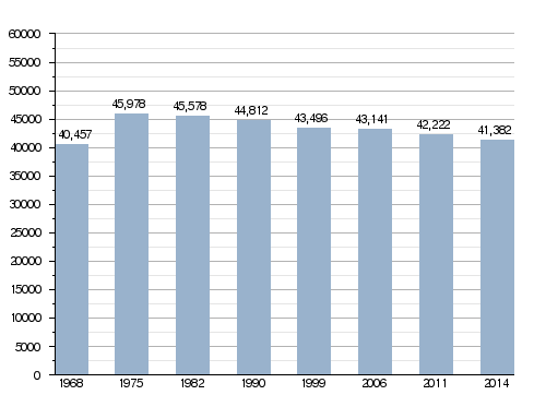
Population
The inhabitants of Castres are known, in French, as Castrais (women: Castraises).
The city of Castres has a population, in 2014, of 41,382; its population density is of 422 inhabitants/km2.
Evolution of the population in Castres
Administration
Castres is a subprefecture of the Tarn department and the capital of the arrondissement of Castres in the same department. It is also the capital of three Cantons:
- Castres-1, formed with a part of Castres (16,890 inhabitants) (2014)
- Castres-2, formed with a part of Castres and 6 other communes (15,422 inhabitants) (2014)
- Castres-3, formed with a part of Castres and the commune Navès (15,319 inhabitants) (2014)
It is part of the intercommunality Castres - Mazamet (French: Communauté d'agglomération de Castres - Mazamet).
Education
Sister cities
Castres is twinned with:
Gallery
-
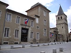
Castres Town Hall
-
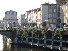
Castres and the Agout river
-
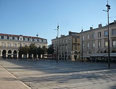
Jean Jaurès square, Castre
-
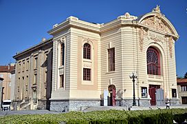
Municipal theatre, Castre
_Hotel_de_ville_et_mus%C3%A9e.JPG)


Related pages
Images for kids
-
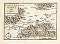
Map showing Castres and the surrounding region, 1638.
-
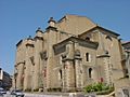
Cathedral of Saint Benoît in Castres


See also
 In Spanish: Castres (Tarn) para niños
