
Cave Springs, Arkansas facts for kids
Quick facts for kids
Cave Springs, Arkansas
|
|
|---|---|

Downtown Cave Springs looking north along Highway 112.
|
|

Location of Cave Springs in Benton County, Arkansas.
|
|
| Country | United States |
| State | Arkansas |
| County | Benton |
| Area | |
| • Total | 7.81 sq mi (20.24 km2) |
| • Land | 7.76 sq mi (20.09 km2) |
| • Water | 0.05 sq mi (0.14 km2) |
| Elevation | 1,155 ft (352 m) |
| Population
(2020)
|
|
| • Total | 5,495 |
| • Density | 708.21/sq mi (273.45/km2) |
| Time zone | UTC-6 (Central (CST)) |
| • Summer (DST) | UTC-5 (CDT) |
| ZIP code |
72718
|
| Area code(s) | 479 |
| FIPS code | 05-12340 |
| GNIS feature ID | 0076553 |
Cave Springs is a city in Benton County, Arkansas. The population was 5,495 at the time of the 2020 census, up from 1,729 in 2010 census. It is part of the Northwest Arkansas metropolitan area.

Geography
Cave Springs is located in southern central Benton County at 36°16′40″N 94°13′24″W / 36.27778°N 94.22333°W (36.277729, -94.223226), in the valley of Osage Creek. Arkansas Highway 112 (Main Street) leads north 8 miles (13 km) to Bentonville and south 16 miles (26 km) to Fayetteville. Arkansas Highway 264 (East Lowell Avenue) leads east 6 miles (10 km) to Lowell and west (as Healing Springs Road) 5 miles (8 km) to Northwest Arkansas Regional Airport.
According to the United States Census Bureau, the city has a total area of 6.9 square miles (18.0 km2), of which 6.9 square miles (17.8 km2) is land and 0.077 square miles (0.2 km2), or 0.84%, is water. Lake Keith, a small water basin in the middle of Cave Springs, holds the rare cave fish. Fishing in Lake Keith has been banned due to the endangered species. In October 2013, Lake Keith was temporarily drained.
Demographics
| Historical population | |||
|---|---|---|---|
| Census | Pop. | %± | |
| 1930 | 192 | — | |
| 1940 | 285 | 48.4% | |
| 1950 | 267 | −6.3% | |
| 1960 | 281 | 5.2% | |
| 1970 | 469 | 66.9% | |
| 1980 | 429 | −8.5% | |
| 1990 | 465 | 8.4% | |
| 2000 | 1,103 | 137.2% | |
| 2010 | 1,729 | 56.8% | |
| 2020 | 5,495 | 217.8% | |
| U.S. Decennial Census 2015 Estimate |
|||
2020 census
| Race | Number | Percentage |
|---|---|---|
| White (non-Hispanic) | 4,508 | 82.04% |
| Black or African American (non-Hispanic) | 100 | 1.82% |
| Native American | 49 | 0.89% |
| Asian | 92 | 1.67% |
| Pacific Islander | 4 | 0.07% |
| Other/Mixed | 397 | 7.22% |
| Hispanic or Latino | 345 | 6.28% |
As of the 2020 United States census, there were 5,495 people, 1,421 households, and 1,255 families residing in the city. The population density was 250.9 people per square mile. In the city, 32.9% of persons were under the age of 18 and 8.6% were 65 years of age or older. For every 100 females, there were 105.8 males.
Cave Springs is the wealthiest city in Arkansas. The median income for a household in the city is $114,286. The per capita income for the city is $140,703. Only about 2.6% of the population lies below the poverty line.

Education
Public education for elementary and secondary students is provided by two school districts. The major school district is Bentonville School District, which leads to graduation from Bentonville High School. For some residents, public education is zoned to the Rogers School District.
Notable people
- Hugh A. Dinsmore, congressman and diplomat
- Bart Hester, member of the Arkansas Senate
- Kendon Underwood, member of the Arkansas House of Representatives
Images for kids
-
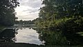
Eastern shore of Lake Keith, looking west.

See also
 In Spanish: Cave Springs para niños
