Centerville, South Carolina facts for kids
Quick facts for kids
Centerville, South Carolina
|
|
|---|---|

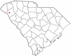
Location of Centerville, South Carolina
|
|
| Country | United States |
| State | South Carolina |
| County | Anderson |
| Area | |
| • Total | 5.9 sq mi (15.4 km2) |
| • Land | 5.9 sq mi (15.3 km2) |
| • Water | 0.04 sq mi (0.1 km2) |
| Elevation | 833 ft (254 m) |
| Population
(2010)
|
|
| • Total | 6,586 |
| • Density | 1,116/sq mi (430.7/km2) |
| Time zone | UTC-5 (Eastern (EST)) |
| • Summer (DST) | UTC-4 (EDT) |
| FIPS code | 45-12965 |
| GNIS feature ID | 1236603 |
Centerville is a census-designated place (CDP) in Anderson County, South Carolina, United States. The population was 6,586 at the 2010 census.
Contents
Geography
Centerville is a suburban area in central Anderson County located at 34°31′21″N 82°42′53″W / 34.52250°N 82.71472°W (34.522505, -82.714756), west of Anderson, the county seat. Interstate 85, the primary highway through Upstate South Carolina, is 4 miles (6 km) to the north at Exit 19. Lake Hartwell is 2 miles (3 km) to the west.
According to the United States Census Bureau, the CDP has a total area of 5.9 square miles (15.4 km2), of which 5.9 square miles (15.3 km2) is land and 0.039 square miles (0.1 km2), or 0.52%, is water.
Demographics
2020 census
| Race | Num. | Perc. |
|---|---|---|
| White (non-Hispanic) | 5,326 | 74.13% |
| Black or African American (non-Hispanic) | 1,250 | 17.4% |
| Native American | 15 | 0.21% |
| Asian | 79 | 1.1% |
| Pacific Islander | 2 | 0.03% |
| Other/Mixed | 288 | 4.01% |
| Hispanic or Latino | 225 | 3.13% |
As of the 2020 United States census, there were 7,185 people, 2,990 households, and 1,870 families residing in the CDP.
See also
 In Spanish: Centerville (Carolina del Sur) para niños

