
Central African Republic facts for kids
Quick facts for kids
Central African Republic
République centrafricaine
Ködörösêse tî Bêafrîka |
|
|---|---|
 Coat of arms
|
|
|
Anthem: La Renaissance (French)
E Zingo (Sango) The Renaissance |
|
.svg) |
|
| Capital and largest city
|
Bangui 4°22′N 18°35′E / 4.367°N 18.583°E |
| Official languages | French Sango |
| Ethnic groups | 33% Baya 27% Banda 13% Mandjia 10% Sara 7% Mboum 4% M'Baka 4% Yakoma 2% other |
| Demonym(s) | Central African |
| Government | Republic |
| Faustin-Archange Touadéra | |
| Firmin Ngrebada | |
| Legislature | National Assembly (suspended) |
| Independence | |
|
• from France
|
13 August 1960 |
| Area | |
|
• Total
|
622,984 km2 (240,535 sq mi) (43rd) |
|
• Water (%)
|
0 |
| Population | |
|
• 2009 estimate
|
4,422,000 (124th) |
|
• 2003 census
|
3,895,150 |
|
• Density
|
7.1/km2 (18.4/sq mi) (223rd) |
| GDP (PPP) | 2011 estimate |
|
• Total
|
$3.641 billion |
|
• Per capita
|
$767 |
| GDP (nominal) | 2011 estimate |
|
• Total
|
$2.165 billion |
|
• Per capita
|
$456 |
| Gini (1993) | 61.3 very high |
| HDI (2011) | 0.343 low · 179th |
| Currency | Central African CFA franc (XAF) |
| Time zone | UTC+1 (WAT) |
|
• Summer (DST)
|
UTC+1 (not observed) |
| Driving side | right |
| Calling code | 236 |
| ISO 3166 code | CF |
| Internet TLD | .cf |

The Central African Republic (CAR) (French: République centrafricaine or Centrafrique Sango Ködörösêse tî Bêafrîka), is a landlocked country in Central Africa. It is mostly a plateau or high, flat piece of land about 941 metres above the sea. The CAR covers a land area of about 620,000 square kilometres (240,000 sq mi), and has an estimated population of about 4.4 million as of 2008. Bangui is the capital city.
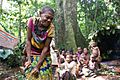
There are thick forests in the south, and these are home to rare gorillas. This part of Africa also has Pygmies.
Other important towns are Bouar, Zinga, and Ouadda. Its southern border is the Ubangi River. There are 3.8 million people in the C.A.R. Most of them belong to the Banda and Baya tribes. The main language is French but some people speak the national language of Sango.
The people mostly grow their own food, but sometimes droughts (long spells without any rain) make this difficult. The C.A.R. also has diamond and uranium mines. It sells these, as well as cotton, coffee, and timber to other countries to make money.
The currency used is the CFA Franc - 1 US Dollar is worth 590.3 CFA Francs.
The country was ruled by France until 1960 when it became independent.
The country has not been very stable since then, with multiple wars with itself, and corruption.
Geography

The Central African Republic is a landlocked nation. It is bordered by the countries of Cameroon, Chad, Sudan, South Sudan, the Democratic Republic of the Congo and the Republic of the Congo.
Much of the Central African Republic is flat, or rolling plateau savanna. It is typically about 500 metres (1,640 ft) above sea level. Most of the northern half is in the World Wildlife Fund's East Sudanian savanna ecoregion. In the northeast are the Fertit Hills. There are scattered hills in the southwest part of the country. To the northwest is the Yade Massif, a granite plateau with an altitude of 1,143 feet (348 m).
At 622,941 square kilometres (240,519 sq mi), the Central African Republic is the world's 42nd-largest country. It is about the size of the Ukraine, and is somewhat smaller than the US state of Texas.
Much of the southern border is formed by tributaries of the Congo River. The Mbomou River in the east merges with the Uele River to form the Ubangi River. In the west, the Sangha River flows through part of the country. The eastern border is along the edge of the Nile River watershed.
Forest covers up to 8% of the land. The densest parts are in the south. The forest is highly diverse. It includes commercially important species of Ayous, Sapelli and Sipo. The deforestation rate is 0.4% per year, and lumber poaching is commonplace.
Prefectures
The Central African Republic is divided into 14 administrative prefectures. There are also 2 economic prefectures and one autonomous commune. The prefectures are further divided into 71 sub-prefectures.
The prefectures of the Central African Republic are:
The two economic prefectures are Nana-Grébizi and Sangha-Mbaéré. The commune is Bangui.
Cities

The largest cities in the Central African Republic are:
- Bangui - 622,771 (census 2006)
- Bimbo - 124,176
- Berbérati - 76,918
- Carnot - 45,421
- Bambari - 41,356
- Bouar - 40,303
- Bossangoa - 36,478
- Bria - 35,204
- Bangassou - 31,553
- Nola - 29,181
Related pages
- The Central African Republic at the Olympics
- Central African Republic national football team
- List of rivers of the Central African Republic
 |
Cameroon | Chad | Sudan | |
| Cameroon | South Sudan | |||
| Republic of the Congo | Democratic Republic of the Congo | Democratic Republic of the Congo |
Images for kids
-
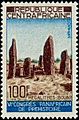
The Bouar Megaliths, pictured here on a 1967 Central African stamp, date back to the very late Neolithic Era (c. 3500–2700 BCE).
-
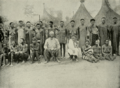
The Sultan of Bangassou and his wives, 1906
-
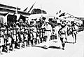
Charles de Gaulle in Bangui, 1940.
-
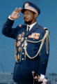
Jean-Bédel Bokassa, self-crowned Emperor of Central Africa
-
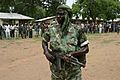
Rebel militia in the northern countryside, 2007.
-
Refugees of the fighting in the Central African Republic, January 2014
-
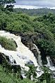
Falls of Boali on the Mbali River
-
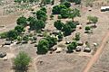
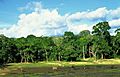
A village in the Central African Republic
-
Dzanga-Sangha Reserve
-

Fula women in Paoua
-
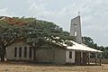
A Christian church in the Central African Republic
-
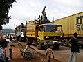
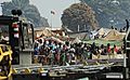
Trucks in Bangui
-
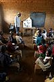
Classroom in Sam Ouandja
-
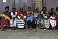
Mothers and babies aged between 0 and 5 years are lining up in a Health Post at Begoua, a district of Bangui, waiting for the two drops of the oral polio vaccine.
-
A Central African woman


_-_Eglise_de_brousse_1.jpg)


See also
 In Spanish: República Centroafricana para niños
