
Central California facts for kids
Quick facts for kids
Central California
|
|
|---|---|
|
Region of California
|
|

Central California is most commonly identified with 10 counties in the southeast part of Northern California
|
|
| Country | United States |
| State | California |
| Region | Central California |
| Time zone | Pacific Standard Time |
| • Summer (DST) | Pacific Daylight Time |
| Area code(s) | 209, 559, 661, 805, 831 |
Central California is generally thought of as the middle third of the state, north of Southern California, which includes Los Angeles, and south of Northern California, which includes San Francisco. It includes the northern portion of the San Joaquin Valley (which itself is the southern portion of the Central Valley, beginning at the Sacramento–San Joaquin River Delta), part of the Central Coast, the central hills of the California Coast Ranges and the foothills and mountain areas of the central Sierra Nevada.
Central California is considered to be west of the crest of the Sierra Nevada. East of the Sierra is Eastern California. The largest cities in the region (over 50,000 population), from most to least populous, are Fresno, Bakersfield, Stockton, Modesto, Salinas, Visalia, Clovis, Santa Maria, Merced, Turlock, Madera, Lodi, Tulare, Porterville, Hanford and Delano. Over time, droughts and wildfires have increased in frequency and become less seasonal and more year-round, further straining the region's water security.
Geography
Central California can have widely varying definitions depending on the context. Some divide the state by lines of latitude making northern, central and southern sections. Others divide by county lines or watershed boundaries. Some definitions include more of the San Joaquin Valley and even larger portions of the Central Valley. Some have less or none of Central Coast.
Generally the widest definition of central California is the middle third of the state by latitude.

Counties
Central California as defined above includes the following 10 counties:
Cities
Area cities and towns listed below are major regional centers or county seats.

Sub-regions
The following regions are entirely contained within central California:
- Big Sur
- Kings Canyon National Park
- Metropolitan Fresno
- Pinnacles National Park
- Salinas Valley
- Sequoia National Park
- Yosemite National Park
The following regions are partly contained within central California:
- California Coast Ranges
- Central Coast
- Diablo Range
- Gold Country
- San Francisco Bay Area
- San Joaquin Valley
- Sierra Nevada Mountains
Education
Central California has opened two new universities recently, one in each of the past two decades.
The University of California has one campus in the region. University of California, Merced opened on a newly constructed site on the east side of Merced in 2005.
The California State University system has four campuses in the region. California State University, Monterey Bay opened on the site of the former Fort Ord army base in 1994. California State University, Stanislaus in Turlock opened in 1957. California State University, Fresno opened in 1911.
The Monterey Institute of International Studies is a graduate school that offers eleven master's degree programs in international policy, international management, language teaching, and translation and interpretation. The Monterey Institute of International Studies is a graduate school of Middlebury College.
San Joaquin College of Law is a private, nonprofit law school located in Clovis.
Fresno Pacific University is a private university in Fresno.
The Naval Postgraduate School and Defense Language Institute are located in Monterey.
The following community college campus sites are in the region:
- Columbia College in Sonora, Tuolumne County
- Clovis Community College in Clovis, Fresno County
- Fresno City College in Fresno, Fresno County
- Hartnell College in Salinas, Monterey County
- Merced College in Merced, Merced County
- Modesto Junior College in Modesto, Stanislaus County
- Monterey Peninsula College, Monterey, Monterey County
- Porterville College in Porterville, Tulare County
- Reedley College in Fresno, Fresno County
- College of the Sequoias in Visalia, Tulare County
- West Hills College Coalinga in Coalinga, Fresno County
- West Hills College Lemoore in Lemoore, Kings County
- Madera Community College in Madera, Madera County
- Oakhurst Community College Center in Oakhurst, Madera County
There are no community colleges in Mariposa or San Benito Counties.
Major highways
Most of the major highways in the region run north-south around the mountains. Interstate 5 and State Route 99 are the primary highways in the San Joaquin Valley. US 101 and State Route 1 are the major coastal highways.
|
|
Rail
Passenger rail in the region consists of the Amtrak long-haul Coast Starlight and Amtrak California San Joaquin routes.
The California High-Speed Rail system is under planning. If built, it would have stations in Fresno and Merced on the initial line between San Francisco/San Jose and Los Angeles.
Freight rail is served by commercial railroads. Union Pacific Railroad and BNSF Railway operate mainline freight through the region in the Central Valley.
Air
Major and regional airline service are available at Fresno Yosemite International Airport and Monterey Regional Airport. Regional airline service is also available at Modesto City-County Airport, Merced Municipal Airport and Visalia Municipal Airport.
General Aviation airports exist in all 10 counties. The largest are former military bases converted to civilian airports
- Castle Airport in Merced County
- Marina Municipal Airport in Monterey County
- Porterville Municipal Airport in Tulare County
- Salinas Municipal Airport in Monterey County
- Visalia Municipal Airport in Tulare County
An active military air base is at Naval Air Station Lemoore in Kings County and the 144th Fighter Wing is stationed at Fresno Air National Guard Base in Fresno County
Images for kids
-
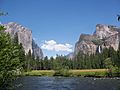
Merced River from Yosemite

